![](/images/other/stat-length.png)
![Randonnée Marche Barèges - Pic de MADAMETE - Photo](https://media.geolcdn.com/t/1900/400/ext.pjpeg?maxdim=2&url=https%3A%2F%2Fstatic1.geolcdn.com%2Fsiteimages%2Fupload%2Ffiles%2F1553511878bg_sport_marche.png)
Pic de MADAMETE
fredopaca
Utilisateur
![Longueur](/images/other/stat-length.png)
Longueur
17,9 km
![Altitude max](https://static1.geolcdn.com/siteimages/upload/files/1508320355ic_sort_altitude_max_24dp.png)
Altitude max
2640 m
![Dénivelé positif](https://static1.geolcdn.com/siteimages/upload/files/1508320355ic_sort_den_pos_24dp.png)
Dénivelé positif
1211 m
![Km-Effort](/images/other/stat-length.png)
Km-Effort
34 km
![Altitude min](https://static1.geolcdn.com/siteimages/upload/files/1508320355ic_sort_altitude_min_24dp.png)
Altitude min
1451 m
![Dénivelé négatif](https://static1.geolcdn.com/siteimages/upload/files/1508320355ic_sort_den_neg_24dp.png)
Dénivelé négatif
1211 m
![Boucle](https://static1.geolcdn.com/siteimages/upload/files/16400158638029165_repeat_loop_refresh_sync_direction_icon.png)
Boucle
Oui
Date de création :
2019-01-15 17:03:19.611
Dernière modification :
2019-01-15 17:03:19.611
![Marche](https://static1.geolcdn.com/sitytour/trail-icons/101.png)
6h49
Difficulté : Moyen
![Scannez ce code QR pour ouvrir la randonnée dans l'application SityTrail](https://capi.geolives.com/qq0zvz2zws4bq2lad0pu/sitytour/trails/1049039/qr.png?size=200)
Application GPS de randonnée GRATUITE
À propos
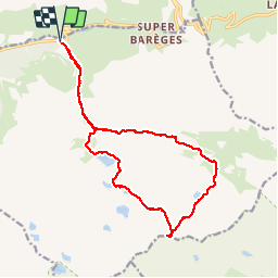
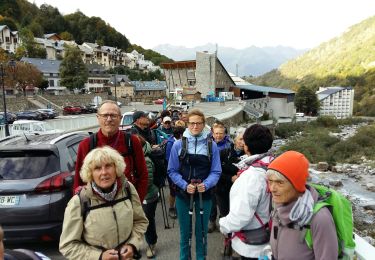
Randonnée Marche de 17,9 km à découvrir à Occitanie, Hautes-Pyrénées, Barèges. Cette randonnée est proposée par fredopaca.
Description
Départ station Barége parking du portaloup vers balise du Pountou prendre sur la droite la cabane dets coubous col de tracens Pic de Madaméte 2657 redescendre vers col de Madaméte cabane de la Pégue et balise Pountou et parking Tournaloup
Localisation
Pays :
France
Région :
Occitanie
Département/Province :
Hautes-Pyrénées
Commune :
Barèges
Localité :
Unknown
Départ:(Dec)
Départ:(UTM)
263363 ; 4754168 (31T) N.
Commentaires
Randonnées à proximité
![Randonnée Marche Barèges - Pic des Trois Conseillers - Photo](https://media.geolcdn.com/t/375/260/ext.jpg?maxdim=2&url=https%3A%2F%2Fservices.sitytrail.com%2FGeolivesWS%2FDownloadMedia.ashx%3FTrailID%3D172698%26Media%3D14081_6.jpg)
![Marche Marche](https://static1.geolcdn.com/sitytour/trail-icons/101.png)
Pic des Trois Conseillers
Marche
Très difficile
(1)
Barèges,
Occitanie,
Hautes-Pyrénées,
France
![](/images/other/stat-length.png)
16 km | 34 km-effort
9h 0min
![](https://static1.geolcdn.com/siteimages/upload/files/16400158638029165_repeat_loop_refresh_sync_direction_icon.png)
Oui
![Randonnée Marche Barèges - Pic de Madamète en boucle par les lacs - Photo](https://media.geolcdn.com/t/375/260/ext.jpg?maxdim=2&url=https%3A%2F%2Fservices.sitytrail.com%2FGeolivesWS%2FDownloadMedia.ashx%3FTrailID%3D107077%26Media%3D11899_5.jpg)
![Marche Marche](https://static1.geolcdn.com/sitytour/trail-icons/101.png)
Pic de Madamète en boucle par les lacs
Marche
Difficile
(1)
Barèges,
Occitanie,
Hautes-Pyrénées,
France
![](/images/other/stat-length.png)
21 km | 40 km-effort
9h 0min
![](https://static1.geolcdn.com/siteimages/upload/files/16400158638029165_repeat_loop_refresh_sync_direction_icon.png)
Oui
![Randonnée Randonnée équestre Sers - Plateau d’Aoube par la cabane d’Aoube - Photo](https://media.geolcdn.com/t/375/260/d0a193ac-ccc5-435d-ab72-b3f01c20ee9b.jpg&format=jpg&maxdim=2)
![Randonnée équestre Randonnée équestre](https://static1.geolcdn.com/sitytour/trail-icons/301.png)
Plateau d’Aoube par la cabane d’Aoube
Randonnée équestre
Facile
Sers,
Occitanie,
Hautes-Pyrénées,
France
![](/images/other/stat-length.png)
7,4 km | 15,1 km-effort
4h 43min
![](https://static1.geolcdn.com/siteimages/upload/files/16400158638029165_repeat_loop_refresh_sync_direction_icon.png)
Oui
![Randonnée Marche Barèges - BAREGES le tour des plateaux G4 reco 3264577 - Photo](https://media.geolcdn.com/t/375/260/d3369853-4ed9-48c9-b0c7-23b9f6db24d3.jpg&format=jpg&maxdim=2)
![Marche Marche](https://static1.geolcdn.com/sitytour/trail-icons/101.png)
BAREGES le tour des plateaux G4 reco 3264577
Marche
Moyen
Barèges,
Occitanie,
Hautes-Pyrénées,
France
![](/images/other/stat-length.png)
7,2 km | 11 km-effort
2h 4min
![](https://static1.geolcdn.com/siteimages/upload/files/16400158638029165_repeat_loop_refresh_sync_direction_icon.png)
Oui
![Randonnée Marche Bagnères-de-Bigorre - tourmalet G2 heit - Photo](https://media.geolcdn.com/t/375/260/8cd371a0-9f70-473d-b4f9-0ddefaeeb150.jpg&format=jpg&maxdim=2)
![Marche Marche](https://static1.geolcdn.com/sitytour/trail-icons/101.png)
tourmalet G2 heit
Marche
Très facile
Bagnères-de-Bigorre,
Occitanie,
Hautes-Pyrénées,
France
![](/images/other/stat-length.png)
5,5 km | 11,6 km-effort
6h 37min
![](https://static1.geolcdn.com/siteimages/upload/files/16400158638029165_repeat_loop_refresh_sync_direction_icon.png)
Oui
![Randonnée Marche Barèges - En boucle, Grand Tourmalet- Aygues Cluses-Col de Madamète- Lac Dets Coubous. - Photo](https://media.geolcdn.com/t/375/260/ext.jpg?maxdim=2&url=https%3A%2F%2Fstatic1.geolcdn.com%2Fsiteimages%2Fupload%2Ffiles%2F1553511878bg_sport_marche.png)
![Marche Marche](https://static1.geolcdn.com/sitytour/trail-icons/101.png)
En boucle, Grand Tourmalet- Aygues Cluses-Col de Madamète- Lac Dets Coubous.
Marche
Difficile
(3)
Barèges,
Occitanie,
Hautes-Pyrénées,
France
![](/images/other/stat-length.png)
16,7 km | 32 km-effort
6h 26min
![](https://static1.geolcdn.com/siteimages/upload/files/16400158638029165_repeat_loop_refresh_sync_direction_icon.png)
Oui
![Randonnée Marche Barèges - Bareges St Justin - Photo](https://media.geolcdn.com/t/375/260/1c3cf81f-9908-4ac1-bcb6-4709b37a0797.jpg&format=jpg&maxdim=2)
![Marche Marche](https://static1.geolcdn.com/sitytour/trail-icons/101.png)
Bareges St Justin
Marche
Très facile
Barèges,
Occitanie,
Hautes-Pyrénées,
France
![](/images/other/stat-length.png)
5,2 km | 6,9 km-effort
1h 38min
![](https://static1.geolcdn.com/siteimages/upload/files/16400158638029165_repeat_loop_refresh_sync_direction_icon.png)
Oui
![Randonnée Marche Sers - BAREGES G4 le tour des plateaux](https://media.geolcdn.com/t/375/260/3b1a88cc-7c19-44dc-b1bc-bd751409e5bf.jpg&format=jpg&maxdim=2)
![Marche Marche](https://static1.geolcdn.com/sitytour/trail-icons/101.png)
BAREGES G4 le tour des plateaux "3430845"
Marche
Moyen
Sers,
Occitanie,
Hautes-Pyrénées,
France
![](/images/other/stat-length.png)
7,1 km | 11 km-effort
2h 9min
![](https://static1.geolcdn.com/siteimages/upload/files/16400158638029165_repeat_loop_refresh_sync_direction_icon.png)
Oui
![Randonnée Marche Barèges - BAREGES le plateau des lumieres G3 fait](https://media.geolcdn.com/t/375/260/54fb900f-7849-4894-bd99-4b851200d9f6.jpg&format=jpg&maxdim=2)
![Marche Marche](https://static1.geolcdn.com/sitytour/trail-icons/101.png)
BAREGES le plateau des lumieres G3 fait "3416084"
Marche
Difficile
Barèges,
Occitanie,
Hautes-Pyrénées,
France
![](/images/other/stat-length.png)
9,1 km | 14,1 km-effort
2h 42min
![](https://static1.geolcdn.com/siteimages/upload/files/16400158638029165_repeat_loop_refresh_sync_direction_icon.png)
Oui