![](/images/other/stat-length.png)
![Randonnée Marche Saint-Christophe-en-Oisans - Tour de la Bérarde - Étape n°3 : Refuge de la Pilatte - La Bérarde - Photo](https://media.geolcdn.com/t/1900/400/ext.pjpeg?maxdim=2&url=https%3A%2F%2Fservices.sitytrail.com%2FGeolivesWS%2FDownloadMedia.ashx%3FTrailID%3D104844%26Media%3D8344_3.jpg)
Tour de la Bérarde - Étape n°3 : Refuge de la Pilatte - La Bérarde
tracegps
Utilisateur
![Longueur](/images/other/stat-length.png)
![Altitude max](https://static1.geolcdn.com/siteimages/upload/files/1508320355ic_sort_altitude_max_24dp.png)
![Dénivelé positif](https://static1.geolcdn.com/siteimages/upload/files/1508320355ic_sort_den_pos_24dp.png)
![Km-Effort](/images/other/stat-length.png)
![Altitude min](https://static1.geolcdn.com/siteimages/upload/files/1508320355ic_sort_altitude_min_24dp.png)
![Dénivelé négatif](https://static1.geolcdn.com/siteimages/upload/files/1508320355ic_sort_den_neg_24dp.png)
![Boucle](https://static1.geolcdn.com/siteimages/upload/files/16400158638029165_repeat_loop_refresh_sync_direction_icon.png)
![Marche](https://static1.geolcdn.com/sitytour/trail-icons/101.png)
4h00
Difficulté : Moyen
![Scannez ce code QR pour ouvrir la randonnée dans l'application SityTrail](https://capi.geolives.com/qq0zvz2zws4bq2lad0pu/sitytour/trails/104844/qr.png?size=200)
Application GPS de randonnée GRATUITE
À propos
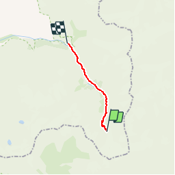
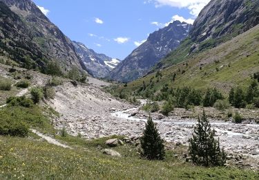
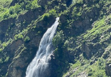
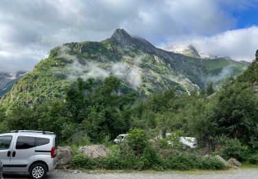
Randonnée Marche de 9,9 km à découvrir à Auvergne-Rhône-Alpes, Isère, Saint-Christophe-en-Oisans. Cette randonnée est proposée par tracegps.
Description
Du Refuge de la Pilatte, redescendre sur la Bérarde. Vous pouvez : -soit repasser la passerelle quand vous êtes à la rivière. -soit vous ne passez pas la passerelle et vous prenez le sentier juste en face (voir carte ign). Attention, car de ce côté, c'est un peu plus long et plus dur, voir même quelques névés.
Localisation
Commentaires
Randonnées à proximité
![Randonnée A pied La Chapelle-en-Valgaudémar - Refuge du Pigeonnier - Photo](https://media.geolcdn.com/t/375/260/ce7c5daf-99aa-48e8-b5ea-75a2997b18fd.jpg&format=jpg&maxdim=2)
![A pied A pied](https://static1.geolcdn.com/sitytour/trail-icons/100.png)
A pied
![](/images/other/stat-length.png)
![](https://static1.geolcdn.com/siteimages/upload/files/16400158638029165_repeat_loop_refresh_sync_direction_icon.png)
![A pied A pied](https://static1.geolcdn.com/sitytour/trail-icons/100.png)
A pied
![](/images/other/stat-length.png)
![](https://static1.geolcdn.com/siteimages/upload/files/16400158638029165_repeat_loop_refresh_sync_direction_icon.png)
![A pied A pied](https://static1.geolcdn.com/sitytour/trail-icons/100.png)
A pied
![](/images/other/stat-length.png)
![](https://static1.geolcdn.com/siteimages/upload/files/16400158638029165_repeat_loop_refresh_sync_direction_icon.png)
![Randonnée Marche La Chapelle-en-Valgaudémar - Chalet-hôtel de Gioberney - boucle Lac du Lauzon - 7.2km 480m 4h30 (1h) - 2018 06 27 - Photo](https://media.geolcdn.com/t/375/260/ext.jpg?maxdim=2&url=https%3A%2F%2Fservices.sitytrail.com%2FGeolivesWS%2FDownloadMedia.ashx%3FTrailID%3D999345%26Media%3Dfix__20180627142404.jpg)
![Marche Marche](https://static1.geolcdn.com/sitytour/trail-icons/101.png)
Marche
![](/images/other/stat-length.png)
![](https://static1.geolcdn.com/siteimages/upload/files/16400158638029165_repeat_loop_refresh_sync_direction_icon.png)
![Randonnée Marche La Chapelle-en-Valgaudémar - Parking du Crépon - AR Gioberney Refuge de Vallonpierre - 16km 850m 7h35 (50mn) - 2018 07 03 - Photo](https://media.geolcdn.com/t/375/260/b31b91c8-a8b7-444d-8b10-22f70d1d8991.jpg&format=jpg&maxdim=2)
![Marche Marche](https://static1.geolcdn.com/sitytour/trail-icons/101.png)
Marche
![](/images/other/stat-length.png)
![](https://static1.geolcdn.com/siteimages/upload/files/16400158638029165_repeat_loop_refresh_sync_direction_icon.png)
![Randonnée Marche La Chapelle-en-Valgaudémar - PARC NATIONAL DES ECRINS: REFUGE DU PIGEONNIER - Photo](https://media.geolcdn.com/t/375/260/63f96214-74ba-423a-b110-db305c3e34c6.jpg&format=jpg&maxdim=2)
![Marche Marche](https://static1.geolcdn.com/sitytour/trail-icons/101.png)
Marche
![](/images/other/stat-length.png)
![](https://static1.geolcdn.com/siteimages/upload/files/16400158638029165_repeat_loop_refresh_sync_direction_icon.png)
![Randonnée Marche Saint-Christophe-en-Oisans - Rando depart du refuge du Carrelet et arrivée à La Berarde - Photo](https://media.geolcdn.com/t/375/260/ba3f2593-4b51-48ac-977d-c1aae9a6266f.jpg&format=jpg&maxdim=2)
![Marche Marche](https://static1.geolcdn.com/sitytour/trail-icons/101.png)
Marche
![](/images/other/stat-length.png)
![](https://static1.geolcdn.com/siteimages/upload/files/16400158638029165_repeat_loop_refresh_sync_direction_icon.png)
![Randonnée Marche La Chapelle-en-Valgaudémar - Valgo 2 - J6 : refuge du Pigeonnier - Photo](https://media.geolcdn.com/t/375/260/c6689721-e653-43be-95d0-5a3d660e8f8a.jpg&format=jpg&maxdim=2)
![Marche Marche](https://static1.geolcdn.com/sitytour/trail-icons/101.png)
Marche
![](/images/other/stat-length.png)
![](https://static1.geolcdn.com/siteimages/upload/files/16400158638029165_repeat_loop_refresh_sync_direction_icon.png)
![Randonnée Marche La Chapelle-en-Valgaudémar - Valgo 2 - J4 : refuge de Vallonpierre - Photo](https://media.geolcdn.com/t/375/260/7d8b3fae-a844-4002-9f15-89f8c2cf8663.jpg&format=jpg&maxdim=2)
![Marche Marche](https://static1.geolcdn.com/sitytour/trail-icons/101.png)
Marche
![](/images/other/stat-length.png)
![](https://static1.geolcdn.com/siteimages/upload/files/16400158638029165_repeat_loop_refresh_sync_direction_icon.png)
Très bon itinéraire, mais la distance est plus proche de 12 km.