![](/images/other/stat-length.png)
![Randonnée Marche Saint-Christophe-en-Oisans - Tour de la Bérarde - Étape n°2 : Refuge Temple des Écrins - Refuge de la Pilatte - Photo](https://media.geolcdn.com/t/1900/400/ext.pjpeg?maxdim=2&url=https%3A%2F%2Fservices.sitytrail.com%2FGeolivesWS%2FDownloadMedia.ashx%3FTrailID%3D104843%26Media%3D8342_6.jpg)
Tour de la Bérarde - Étape n°2 : Refuge Temple des Écrins - Refuge de la Pilatte
tracegps
Utilisateur
![Longueur](/images/other/stat-length.png)
Longueur
6,6 km
![Altitude max](https://static1.geolcdn.com/siteimages/upload/files/1508320355ic_sort_altitude_max_24dp.png)
Altitude max
2583 m
![Dénivelé positif](https://static1.geolcdn.com/siteimages/upload/files/1508320355ic_sort_den_pos_24dp.png)
Dénivelé positif
581 m
![Km-Effort](/images/other/stat-length.png)
Km-Effort
13,8 km
![Altitude min](https://static1.geolcdn.com/siteimages/upload/files/1508320355ic_sort_altitude_min_24dp.png)
Altitude min
1990 m
![Dénivelé négatif](https://static1.geolcdn.com/siteimages/upload/files/1508320355ic_sort_den_neg_24dp.png)
Dénivelé négatif
405 m
![Boucle](https://static1.geolcdn.com/siteimages/upload/files/16400158638029165_repeat_loop_refresh_sync_direction_icon.png)
Boucle
Non
Date de création :
2014-12-10 00:00:00.0
Dernière modification :
2014-12-10 00:00:00.0
![Marche](https://static1.geolcdn.com/sitytour/trail-icons/101.png)
3h30
Difficulté : Moyen
![Scannez ce code QR pour ouvrir la randonnée dans l'application SityTrail](https://capi.geolives.com/qq0zvz2zws4bq2lad0pu/sitytour/trails/104843/qr.png?size=200)
Application GPS de randonnée GRATUITE
À propos
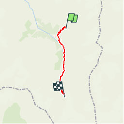
Randonnée Marche de 6,6 km à découvrir à Auvergne-Rhône-Alpes, Isère, Saint-Christophe-en-Oisans. Cette randonnée est proposée par tracegps.
Description
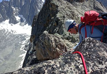
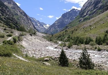
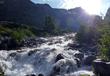
Redescendre du Refuge du Temple des Écrins, longer la rivière jusqu'à une passerelle qu’il faut traverser, boire un coup et monter vers Pilatte. Refuge de la Pilatte, tél.: 04/92241417
Localisation
Pays :
France
Région :
Auvergne-Rhône-Alpes
Département/Province :
Isère
Commune :
Saint-Christophe-en-Oisans
Localité :
Unknown
Départ:(Dec)
Départ:(UTM)
289402 ; 4975761 (32T) N.
Commentaires
Randonnées à proximité
![Randonnée Marche Saint-Christophe-en-Oisans - Saint-Christophe-en-Oisans - La Bérarde Cotillat (le Châtelleret) - 10.7km 390m 5h30 (45mn) - 2018 06 22 - Photo](https://media.geolcdn.com/t/375/260/ext.jpg?maxdim=2&url=https%3A%2F%2Fservices.sitytrail.com%2FGeolivesWS%2FDownloadMedia.ashx%3FTrailID%3D999336%26Media%3Dfix__20180622150554.jpg)
![Marche Marche](https://static1.geolcdn.com/sitytour/trail-icons/101.png)
Saint-Christophe-en-Oisans - La Bérarde Cotillat (le Châtelleret) - 10.7km 39...
Marche
Moyen
Saint-Christophe-en-Oisans,
Auvergne-Rhône-Alpes,
Isère,
France
![](/images/other/stat-length.png)
10,8 km | 16 km-effort
5h 30min
![](https://static1.geolcdn.com/siteimages/upload/files/16400158638029165_repeat_loop_refresh_sync_direction_icon.png)
Oui
![Randonnée Marche Saint-Christophe-en-Oisans - Saint-Christophe-en-Oisans - La Bérarde Refuge du Carrelet - 7.9km 220m 2h50 - 2015 06 20 - Photo](https://media.geolcdn.com/t/375/260/ext.jpg?maxdim=2&url=https%3A%2F%2Fservices.sitytrail.com%2FGeolivesWS%2FDownloadMedia.ashx%3FTrailID%3D436077%26Media%3Dfix__20150620162005.jpg)
![Marche Marche](https://static1.geolcdn.com/sitytour/trail-icons/101.png)
Saint-Christophe-en-Oisans - La Bérarde Refuge du Carrelet - 7.9km 220m 2h50 ...
Marche
Moyen
Saint-Christophe-en-Oisans,
Auvergne-Rhône-Alpes,
Isère,
France
![](/images/other/stat-length.png)
7,9 km | 10,8 km-effort
2h 50min
![](https://static1.geolcdn.com/siteimages/upload/files/16400158638029165_repeat_loop_refresh_sync_direction_icon.png)
Oui
![Randonnée Marche Saint-Christophe-en-Oisans - Saint-Christophe-en-Oisans - La Bérarde la Vallée du Vénéon - 13.4km 390m 4h00 (30mn) - 2014 06 08 - Photo](https://media.geolcdn.com/t/375/260/ext.jpg?maxdim=2&url=https%3A%2F%2Fservices.sitytrail.com%2FGeolivesWS%2FDownloadMedia.ashx%3FTrailID%3D311048%26Media%3Dfix__20140608163517.jpg)
![Marche Marche](https://static1.geolcdn.com/sitytour/trail-icons/101.png)
Saint-Christophe-en-Oisans - La Bérarde la Vallée du Vénéon - 13.4km 390m 4h0...
Marche
Moyen
Saint-Christophe-en-Oisans,
Auvergne-Rhône-Alpes,
Isère,
France
![](/images/other/stat-length.png)
13,4 km | 18,5 km-effort
4h 1min
![](https://static1.geolcdn.com/siteimages/upload/files/16400158638029165_repeat_loop_refresh_sync_direction_icon.png)
Oui
![Randonnée Marche Saint-Christophe-en-Oisans - Cornes de Pié Bérarde - Photo](https://media.geolcdn.com/t/375/260/b365defd-9ad4-4aa5-a793-661817e0b806.jpg&format=jpg&maxdim=2)
![Marche Marche](https://static1.geolcdn.com/sitytour/trail-icons/101.png)
Cornes de Pié Bérarde
Marche
Très difficile
Saint-Christophe-en-Oisans,
Auvergne-Rhône-Alpes,
Isère,
France
![](/images/other/stat-length.png)
9,8 km | 27 km-effort
6h 7min
![](https://static1.geolcdn.com/siteimages/upload/files/16400158638029165_repeat_loop_refresh_sync_direction_icon.png)
Oui
![Randonnée Marche Saint-Christophe-en-Oisans - Rando depart du refuge du Carrelet et arrivée à La Berarde - Photo](https://media.geolcdn.com/t/375/260/ba3f2593-4b51-48ac-977d-c1aae9a6266f.jpg&format=jpg&maxdim=2)
![Marche Marche](https://static1.geolcdn.com/sitytour/trail-icons/101.png)
Rando depart du refuge du Carrelet et arrivée à La Berarde
Marche
Facile
Saint-Christophe-en-Oisans,
Auvergne-Rhône-Alpes,
Isère,
France
![](/images/other/stat-length.png)
4,4 km | 5,3 km-effort
1h 10min
![](https://static1.geolcdn.com/siteimages/upload/files/16400158638029165_repeat_loop_refresh_sync_direction_icon.png)
Non
![Randonnée Marche Saint-Christophe-en-Oisans - Malraux Refuge du Chateleret - Photo](https://media.geolcdn.com/t/375/260/ext.jpg?maxdim=2&url=https%3A%2F%2Fservices.sitytrail.com%2FGeolivesWS%2FDownloadMedia.ashx%3FTrailID%3D1034336%26Media%3D20180904143743.jpg)
![Marche Marche](https://static1.geolcdn.com/sitytour/trail-icons/101.png)
Malraux Refuge du Chateleret
Marche
Facile
Saint-Christophe-en-Oisans,
Auvergne-Rhône-Alpes,
Isère,
France
![](/images/other/stat-length.png)
12,1 km | 19,4 km-effort
5h 26min
![](https://static1.geolcdn.com/siteimages/upload/files/16400158638029165_repeat_loop_refresh_sync_direction_icon.png)
Oui
![Randonnée Marche Saint-Christophe-en-Oisans - REFUGE DE CHATELLERET depuis LA BERARDE-07-09-2016 - Photo](https://media.geolcdn.com/t/375/260/ext.jpg?maxdim=2&url=https%3A%2F%2Fservices.sitytrail.com%2FGeolivesWS%2FDownloadMedia.ashx%3FTrailID%3D630354%26Media%3D20160907160722.jpg)
![Marche Marche](https://static1.geolcdn.com/sitytour/trail-icons/101.png)
REFUGE DE CHATELLERET depuis LA BERARDE-07-09-2016
Marche
Facile
Saint-Christophe-en-Oisans,
Auvergne-Rhône-Alpes,
Isère,
France
![](/images/other/stat-length.png)
14,9 km | 25 km-effort
6h 30min
![](https://static1.geolcdn.com/siteimages/upload/files/16400158638029165_repeat_loop_refresh_sync_direction_icon.png)
Oui
![Randonnée Marche Saint-Christophe-en-Oisans - Crique Glaciaire de Bonne Piere - Photo](https://media.geolcdn.com/t/375/260/ext.jpg?maxdim=2&url=https%3A%2F%2Fservices.sitytrail.com%2FGeolivesWS%2FDownloadMedia.ashx%3FTrailID%3D204258%26Media%3De1de605a-89c1-4c45-b839-cd4121660314.JPG)
![Marche Marche](https://static1.geolcdn.com/sitytour/trail-icons/101.png)
Crique Glaciaire de Bonne Piere
Marche
Difficile
Saint-Christophe-en-Oisans,
Auvergne-Rhône-Alpes,
Isère,
France
![](/images/other/stat-length.png)
11,4 km | 27 km-effort
5h 27min
![](https://static1.geolcdn.com/siteimages/upload/files/16400158638029165_repeat_loop_refresh_sync_direction_icon.png)
Oui
![Randonnée Marche Saint-Christophe-en-Oisans - Tour de la Bérarde - Étape n°3 : Refuge de la Pilatte - La Bérarde - Photo](https://media.geolcdn.com/t/375/260/ext.jpg?maxdim=2&url=https%3A%2F%2Fservices.sitytrail.com%2FGeolivesWS%2FDownloadMedia.ashx%3FTrailID%3D104844%26Media%3D8344_3.jpg)
![Marche Marche](https://static1.geolcdn.com/sitytour/trail-icons/101.png)
Tour de la Bérarde - Étape n°3 : Refuge de la Pilatte - La Bérarde
Marche
Moyen
(1)
Saint-Christophe-en-Oisans,
Auvergne-Rhône-Alpes,
Isère,
France
![](/images/other/stat-length.png)
9,9 km | 13 km-effort
4h 0min
![](https://static1.geolcdn.com/siteimages/upload/files/16400158638029165_repeat_loop_refresh_sync_direction_icon.png)
Non