![](/images/other/stat-length.png)
![Randonnée Course à pied Plouider - Pont du Chatel boucle 13 - Photo](https://media.geolcdn.com/t/1900/400/ext.pjpeg?maxdim=2&url=https%3A%2F%2Fstatic1.geolcdn.com%2Fsiteimages%2Fupload%2Ffiles%2F1524743154running.jpg)
Pont du Chatel boucle 13
tracegps
Utilisateur
![Longueur](/images/other/stat-length.png)
Longueur
9 km
![Altitude max](https://static1.geolcdn.com/siteimages/upload/files/1508320355ic_sort_altitude_max_24dp.png)
Altitude max
71 m
![Dénivelé positif](https://static1.geolcdn.com/siteimages/upload/files/1508320355ic_sort_den_pos_24dp.png)
Dénivelé positif
144 m
![Km-Effort](/images/other/stat-length.png)
Km-Effort
10,9 km
![Altitude min](https://static1.geolcdn.com/siteimages/upload/files/1508320355ic_sort_altitude_min_24dp.png)
Altitude min
8 m
![Dénivelé négatif](https://static1.geolcdn.com/siteimages/upload/files/1508320355ic_sort_den_neg_24dp.png)
Dénivelé négatif
144 m
![Boucle](https://static1.geolcdn.com/siteimages/upload/files/16400158638029165_repeat_loop_refresh_sync_direction_icon.png)
Boucle
Oui
Date de création :
2014-12-10 00:00:00.0
Dernière modification :
2014-12-10 00:00:00.0
![Course à pied](https://static1.geolcdn.com/sitytour/trail-icons/103.png)
1h00
Difficulté : Moyen
![Scannez ce code QR pour ouvrir la randonnée dans l'application SityTrail](https://capi.geolives.com/qq0zvz2zws4bq2lad0pu/sitytour/trails/104814/qr.png?size=200)
Application GPS de randonnée GRATUITE
À propos
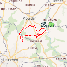
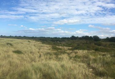
Randonnée Course à pied de 9 km à découvrir à Bretagne, Finistère, Plouider. Cette randonnée est proposée par tracegps.
Description
Depuis Pont du Châtel remontée vers la carrière de Torranech (ancienne carrière abandonnée offrant un superbe plan d'eau), puis plongée vers la vallée du Quilimadec vers Cleusmeur (leneven) et tangentant le bourg de Plouider vers Pont du Chatel.
Localisation
Pays :
France
Région :
Bretagne
Département/Province :
Finistère
Commune :
Plouider
Localité :
Unknown
Départ:(Dec)
Départ:(UTM)
406044 ; 5383484 (30U) N.
Commentaires
Randonnées à proximité
![Randonnée Cyclotourisme Tréflez - de Goulven à St Michel - Photo](https://media.geolcdn.com/t/375/260/d203853a-94a0-4595-a51e-9d7382f0834e.jpg&format=jpg&maxdim=2)
![Cyclotourisme Cyclotourisme](https://static1.geolcdn.com/sitytour/trail-icons/204.png)
de Goulven à St Michel
Cyclotourisme
Moyen
Tréflez,
Bretagne,
Finistère,
France
![](/images/other/stat-length.png)
44 km | 49 km-effort
4h 36min
![](https://static1.geolcdn.com/siteimages/upload/files/16400158638029165_repeat_loop_refresh_sync_direction_icon.png)
Non
![Randonnée Marche nordique Saint-Méen - st méen - Photo](https://media.geolcdn.com/t/375/260/053ac6aa-b95e-4a19-92c5-ec066113aa0b.jpg&format=jpg&maxdim=2)
![Marche nordique Marche nordique](https://static1.geolcdn.com/sitytour/trail-icons/102.png)
st méen
Marche nordique
Très facile
Saint-Méen,
Bretagne,
Finistère,
France
![](/images/other/stat-length.png)
14,9 km | 17,2 km-effort
2h 57min
![](https://static1.geolcdn.com/siteimages/upload/files/16400158638029165_repeat_loop_refresh_sync_direction_icon.png)
Oui
![Randonnée A pied Plouider - Poul Sant Dider - Photo](https://media.geolcdn.com/t/375/260/66d4aee4-cd7f-42c9-b6ca-da83a1ae6e61.jpeg&format=jpg&maxdim=2)
![A pied A pied](https://static1.geolcdn.com/sitytour/trail-icons/100.png)
Poul Sant Dider
A pied
Facile
Plouider,
Bretagne,
Finistère,
France
![](/images/other/stat-length.png)
6,3 km | 7,4 km-effort
1h 41min
![](https://static1.geolcdn.com/siteimages/upload/files/16400158638029165_repeat_loop_refresh_sync_direction_icon.png)
Oui
![Randonnée Marche Tréflez - Dunes de Kerrema - Photo](https://media.geolcdn.com/t/375/260/4a428f42-3ca9-4c82-a360-d7d781480f54.jpg&format=jpg&maxdim=2)
![Marche Marche](https://static1.geolcdn.com/sitytour/trail-icons/101.png)
![Randonnée Marche Tréflez - rando Bretagne 22/09/2020 - Photo](https://media.geolcdn.com/t/375/260/fd1bcefd-1fa3-4720-ab72-7fb58fe2da72.jpg&format=jpg&maxdim=2)
![Marche Marche](https://static1.geolcdn.com/sitytour/trail-icons/101.png)
rando Bretagne 22/09/2020
Marche
Très facile
Tréflez,
Bretagne,
Finistère,
France
![](/images/other/stat-length.png)
9,2 km | 9,8 km-effort
2h 31min
![](https://static1.geolcdn.com/siteimages/upload/files/16400158638029165_repeat_loop_refresh_sync_direction_icon.png)
Oui
![Randonnée Marche Tréflez - La maison des dunes de Kerrema - Photo](https://media.geolcdn.com/t/375/260/e8df4bb6-967d-4c97-ba7e-ab034b784800.jpg&format=jpg&maxdim=2)
![Marche Marche](https://static1.geolcdn.com/sitytour/trail-icons/101.png)
La maison des dunes de Kerrema
Marche
Facile
Tréflez,
Bretagne,
Finistère,
France
![](/images/other/stat-length.png)
3,6 km | 3,8 km-effort
1h 10min
![](https://static1.geolcdn.com/siteimages/upload/files/16400158638029165_repeat_loop_refresh_sync_direction_icon.png)
Oui
![Randonnée Vélo Goulven - 22A - Goulven / Plabennec - Photo](https://media.geolcdn.com/t/375/260/ext.jpg?maxdim=2&url=https%3A%2F%2Fstatic1.geolcdn.com%2Fsiteimages%2Fupload%2Ffiles%2F1524743154velo.jpg)
![Vélo Vélo](https://static1.geolcdn.com/sitytour/trail-icons/200.png)
22A - Goulven / Plabennec
Vélo
Très difficile
Goulven,
Bretagne,
Finistère,
France
![](/images/other/stat-length.png)
57 km | 62 km-effort
3h 28min
![](https://static1.geolcdn.com/siteimages/upload/files/16400158638029165_repeat_loop_refresh_sync_direction_icon.png)
Non
![Randonnée Vélo Goulven - 22A - Goulven / Plouguerneau - Photo](https://media.geolcdn.com/t/375/260/ext.jpg?maxdim=2&url=https%3A%2F%2Fstatic1.geolcdn.com%2Fsiteimages%2Fupload%2Ffiles%2F1524743154velo.jpg)
![Vélo Vélo](https://static1.geolcdn.com/sitytour/trail-icons/200.png)
22A - Goulven / Plouguerneau
Vélo
Très difficile
Goulven,
Bretagne,
Finistère,
France
![](/images/other/stat-length.png)
51 km | 56 km-effort
3h 44min
![](https://static1.geolcdn.com/siteimages/upload/files/16400158638029165_repeat_loop_refresh_sync_direction_icon.png)
Non
![Randonnée Marche Goulven - GR 34® de Goulven à Guissény - Photo](https://media.geolcdn.com/t/375/260/ext.jpg?maxdim=2&url=https%3A%2F%2Fservices.sitytrail.com%2FGeolivesWS%2FDownloadMedia.ashx%3FTrailID%3D316777%26Media%3D5183_1.jpg)
![Marche Marche](https://static1.geolcdn.com/sitytour/trail-icons/101.png)
GR 34® de Goulven à Guissény
Marche
Difficile
Goulven,
Bretagne,
Finistère,
France
![](/images/other/stat-length.png)
28 km | 30 km-effort
5h 30min
![](https://static1.geolcdn.com/siteimages/upload/files/16400158638029165_repeat_loop_refresh_sync_direction_icon.png)
Non