![](/images/other/stat-length.png)
![Randonnée V.T.T. La Roque-en-Provence - Grande Traversée des PréAlpes à VTT : Le Pous - La Vallière - Photo](https://media.geolcdn.com/t/1900/400/ext.pjpeg?maxdim=2&url=https%3A%2F%2Fservices.sitytrail.com%2FGeolivesWS%2FDownloadMedia.ashx%3FTrailID%3D104789%26Media%3D8256_3.jpg)
Grande Traversée des PréAlpes à VTT : Le Pous - La Vallière
tracegps
Utilisateur
![Longueur](/images/other/stat-length.png)
![Altitude max](https://static1.geolcdn.com/siteimages/upload/files/1508320355ic_sort_altitude_max_24dp.png)
![Dénivelé positif](https://static1.geolcdn.com/siteimages/upload/files/1508320355ic_sort_den_pos_24dp.png)
![Km-Effort](/images/other/stat-length.png)
![Altitude min](https://static1.geolcdn.com/siteimages/upload/files/1508320355ic_sort_altitude_min_24dp.png)
![Dénivelé négatif](https://static1.geolcdn.com/siteimages/upload/files/1508320355ic_sort_den_neg_24dp.png)
![Boucle](https://static1.geolcdn.com/siteimages/upload/files/16400158638029165_repeat_loop_refresh_sync_direction_icon.png)
![V.T.T.](https://static1.geolcdn.com/sitytour/trail-icons/202.png)
1h30
Difficulté : Difficile
![Scannez ce code QR pour ouvrir la randonnée dans l'application SityTrail](https://capi.geolives.com/qq0zvz2zws4bq2lad0pu/sitytour/trails/104789/qr.png?size=200)
Application GPS de randonnée GRATUITE
À propos
Randonnée V.T.T. de 10,1 km à découvrir à Provence-Alpes-Côte d'Azur, Alpes-Maritimes, La Roque-en-Provence. Cette randonnée est proposée par tracegps.
Description
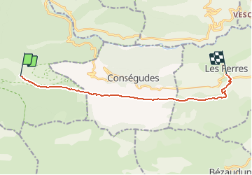
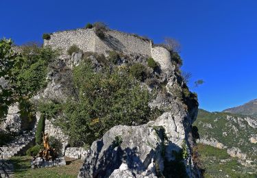
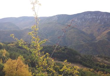
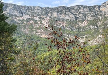
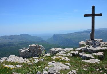
Grande Traversée des Préalpes, les Chemins du Soleil. Parcours officiel labellisé par la Fédération Française de Cyclisme. Peu de difficulté sur ce tronçon plutôt familial qui évolue sur un chemin en balcon au cœur de la réserve du biologique du Cheiron. Malgré tout, la descente des Ferres reste technique voir chaotique et ravira les pilotes plus habiles. Les points de vue panoramiques vous offrent un pêle-mêle des vallées, chaînes de montagnes et villages perchés. Mesure de prudence : la descente sur les Ferres peut s'avérer secouante et difficile pour certains. Consultez toutes les informations sur les hébergements et les services associés sur la fiche du tronçon.
Localisation
Commentaires
Randonnées à proximité
![Randonnée A pied Cuébris - Traversée de l'Estéron - Etape 4 - Photo](https://media.geolcdn.com/t/375/260/f8de4af9-418d-46b2-8971-b8252c239bb2.jpeg&format=jpg&maxdim=2)
![A pied A pied](https://static1.geolcdn.com/sitytour/trail-icons/100.png)
A pied
![](/images/other/stat-length.png)
![](https://static1.geolcdn.com/siteimages/upload/files/16400158638029165_repeat_loop_refresh_sync_direction_icon.png)
![Randonnée A pied Sigale - Circuit de la Cacia - Photo](https://media.geolcdn.com/t/375/260/af8f583b-85f0-4a9c-891f-ad74e419fc87.jpeg&format=jpg&maxdim=2)
![A pied A pied](https://static1.geolcdn.com/sitytour/trail-icons/100.png)
A pied
![](/images/other/stat-length.png)
![](https://static1.geolcdn.com/siteimages/upload/files/16400158638029165_repeat_loop_refresh_sync_direction_icon.png)
![Randonnée A pied Gréolières - Cime du Cheiron - Photo](https://media.geolcdn.com/t/375/260/273aae50-c65a-44a2-8836-25bdf1d17610.jpeg&format=jpg&maxdim=2)
![A pied A pied](https://static1.geolcdn.com/sitytour/trail-icons/100.png)
A pied
![](/images/other/stat-length.png)
![](https://static1.geolcdn.com/siteimages/upload/files/16400158638029165_repeat_loop_refresh_sync_direction_icon.png)
![Randonnée Marche Sigale - Cime CACCIA, SIGALE (06) - Photo](https://media.geolcdn.com/t/375/260/ext.jpg?maxdim=2&url=https%3A%2F%2Fservices.sitytrail.com%2FGeolivesWS%2FDownloadMedia.ashx%3FTrailID%3D497165%26Media%3Dfix__20151125111722.jpg)
![Marche Marche](https://static1.geolcdn.com/sitytour/trail-icons/101.png)
Marche
![](/images/other/stat-length.png)
![](https://static1.geolcdn.com/siteimages/upload/files/16400158638029165_repeat_loop_refresh_sync_direction_icon.png)
![Randonnée Marche Gréolières - Cretes du Cheiron - Photo](https://media.geolcdn.com/t/375/260/88c8f012-b9cc-414c-b278-7a06867d8cc1.jpg&format=jpg&maxdim=2)
![Marche Marche](https://static1.geolcdn.com/sitytour/trail-icons/101.png)
Marche
![](/images/other/stat-length.png)
![](https://static1.geolcdn.com/siteimages/upload/files/16400158638029165_repeat_loop_refresh_sync_direction_icon.png)
![Randonnée Marche Sigale - Sigale, Cime Caccia, Clue Riolan - Photo](https://media.geolcdn.com/t/375/260/84c34767-08d5-415b-9b57-1ef1e0464efe.jpg&format=jpg&maxdim=2)
![Marche Marche](https://static1.geolcdn.com/sitytour/trail-icons/101.png)
Marche
![](/images/other/stat-length.png)
![](https://static1.geolcdn.com/siteimages/upload/files/16400158638029165_repeat_loop_refresh_sync_direction_icon.png)
![Randonnée Marche Roquestéron - Roquesteron : la cime de la Cacia - Photo](https://media.geolcdn.com/t/375/260/5b4bd870-0e3f-40d7-b02e-71dce0b18c61.jpg&format=jpg&maxdim=2)
![Marche Marche](https://static1.geolcdn.com/sitytour/trail-icons/101.png)
Marche
![](/images/other/stat-length.png)
![](https://static1.geolcdn.com/siteimages/upload/files/16400158638029165_repeat_loop_refresh_sync_direction_icon.png)
![Marche Marche](https://static1.geolcdn.com/sitytour/trail-icons/101.png)
Marche
![](/images/other/stat-length.png)
![](https://static1.geolcdn.com/siteimages/upload/files/16400158638029165_repeat_loop_refresh_sync_direction_icon.png)
![Randonnée Marche Roquestéron - mont auviere de roquesteron - Photo](https://media.geolcdn.com/t/375/260/4e4b5cca-21a1-4d3e-af8b-c74d25458d28.jpg&format=jpg&maxdim=2)
![Marche Marche](https://static1.geolcdn.com/sitytour/trail-icons/101.png)
Marche
![](/images/other/stat-length.png)
![](https://static1.geolcdn.com/siteimages/upload/files/16400158638029165_repeat_loop_refresh_sync_direction_icon.png)