![](/images/other/stat-length.png)
![Randonnée V.T.T. Mirabeau - Grande Traversée des PréAlpes à VTT : Mirabeau - La Jasse - Photo](https://media.geolcdn.com/t/1900/400/ext.pjpeg?maxdim=2&url=https%3A%2F%2Fservices.sitytrail.com%2FGeolivesWS%2FDownloadMedia.ashx%3FTrailID%3D104767%26Media%3D8220_2.jpg)
Grande Traversée des PréAlpes à VTT : Mirabeau - La Jasse
tracegps
Utilisateur
![Longueur](/images/other/stat-length.png)
![Altitude max](https://static1.geolcdn.com/siteimages/upload/files/1508320355ic_sort_altitude_max_24dp.png)
![Dénivelé positif](https://static1.geolcdn.com/siteimages/upload/files/1508320355ic_sort_den_pos_24dp.png)
![Km-Effort](/images/other/stat-length.png)
![Altitude min](https://static1.geolcdn.com/siteimages/upload/files/1508320355ic_sort_altitude_min_24dp.png)
![Dénivelé négatif](https://static1.geolcdn.com/siteimages/upload/files/1508320355ic_sort_den_neg_24dp.png)
![Boucle](https://static1.geolcdn.com/siteimages/upload/files/16400158638029165_repeat_loop_refresh_sync_direction_icon.png)
![V.T.T.](https://static1.geolcdn.com/sitytour/trail-icons/202.png)
2h30
Difficulté : Moyen
![Scannez ce code QR pour ouvrir la randonnée dans l'application SityTrail](https://capi.geolives.com/qq0zvz2zws4bq2lad0pu/sitytour/trails/104767/qr.png?size=200)
Application GPS de randonnée GRATUITE
À propos
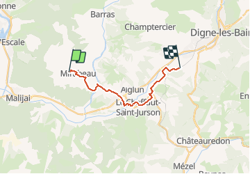
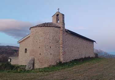
Randonnée V.T.T. de 14,8 km à découvrir à Provence-Alpes-Côte d'Azur, Alpes-de-Haute-Provence, Mirabeau. Cette randonnée est proposée par tracegps.
Description
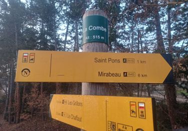
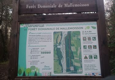
Grande Traversée des Préalpes, les Chemins du Soleil. Parcours officiel labellisé par la Fédération Française de Cyclisme. De Mirabeau, l'itinéraire rejoint la vallée de la Bléone par une descente agréable à travers les pâturages. Vous entrez dans le Pays Dignois. Peu de difficulté, de nombreuses animations jalonnent le parcours (accro branche, baignade...) Consultez toutes les informations sur les hébergements et les services associés sur la fiche du tronçon.
Localisation
Commentaires
Randonnées à proximité
![Randonnée Marche L'Escale - Les Balcons de la Durance 11.2.24 - Photo](https://media.geolcdn.com/t/375/260/0c181ea8-d592-4fc1-a24c-1c5ed7f6ced7.jpg&format=jpg&maxdim=2)
![Marche Marche](https://static1.geolcdn.com/sitytour/trail-icons/101.png)
Marche
![](/images/other/stat-length.png)
![](https://static1.geolcdn.com/siteimages/upload/files/16400158638029165_repeat_loop_refresh_sync_direction_icon.png)
![Randonnée Marche Le Chaffaut-Saint-Jurson - ESPINOUSSE . LES RAGOTS O L S - Photo](https://media.geolcdn.com/t/375/260/be64adbe-0b8d-4834-8b08-174d77c29be7.jpg&format=jpg&maxdim=2)
![Marche Marche](https://static1.geolcdn.com/sitytour/trail-icons/101.png)
Marche
![](/images/other/stat-length.png)
![](https://static1.geolcdn.com/siteimages/upload/files/16400158638029165_repeat_loop_refresh_sync_direction_icon.png)
![Randonnée Marche L'Escale - L ESCALE . LES BALCONS DE LA DURANCE . O - Photo](https://media.geolcdn.com/t/375/260/3fa23b3f-4fd1-41d6-a6cb-c36da6763f5a.jpg&format=jpg&maxdim=2)
![Marche Marche](https://static1.geolcdn.com/sitytour/trail-icons/101.png)
Marche
![](/images/other/stat-length.png)
![](https://static1.geolcdn.com/siteimages/upload/files/16400158638029165_repeat_loop_refresh_sync_direction_icon.png)
![Randonnée Marche Mallemoisson - MALLEMOISSON . LES THUMINS . LE CHATEAU . MIRABEAU . CHAPELLE S PHILIPPE . N. EAU - Photo](https://media.geolcdn.com/t/375/260/fa075058-6ed2-4835-9bce-3a241d712d49.jpg&format=jpg&maxdim=2)
![Marche Marche](https://static1.geolcdn.com/sitytour/trail-icons/101.png)
Marche
![](/images/other/stat-length.png)
![](https://static1.geolcdn.com/siteimages/upload/files/16400158638029165_repeat_loop_refresh_sync_direction_icon.png)
![Randonnée Marche Aiglun - AIGLUN. Le vieil Aiglun , sommet du Puy o l s - Photo](https://media.geolcdn.com/t/375/260/79f9a8c4-2d87-4650-b00f-e4d73efa9932.jpg&format=jpg&maxdim=2)
![Marche Marche](https://static1.geolcdn.com/sitytour/trail-icons/101.png)
Marche
![](/images/other/stat-length.png)
![](https://static1.geolcdn.com/siteimages/upload/files/16400158638029165_repeat_loop_refresh_sync_direction_icon.png)
![Randonnée Marche L'Escale - L ESCALE , Vierres , la Rouerie , ravin de la pierre taillée, Volonne 0 m s - Photo](https://media.geolcdn.com/t/375/260/beda24b4-9d94-4c54-b5d1-1226c0fcf56b.jpg&format=jpg&maxdim=2)
![Marche Marche](https://static1.geolcdn.com/sitytour/trail-icons/101.png)
Marche
![](/images/other/stat-length.png)
![](https://static1.geolcdn.com/siteimages/upload/files/16400158638029165_repeat_loop_refresh_sync_direction_icon.png)
![Randonnée Marche Mirabeau - MIRABEAU Ravin de Barbarrine , Bastide Blanche , le Ruth , Col des Penitents , la Colette , o l - Photo](https://media.geolcdn.com/t/375/260/30d4dbc9-7161-414d-8349-8cc15cb6dbbd.jpg&format=jpg&maxdim=2)
![Marche Marche](https://static1.geolcdn.com/sitytour/trail-icons/101.png)
Marche
![](/images/other/stat-length.png)
![](https://static1.geolcdn.com/siteimages/upload/files/16400158638029165_repeat_loop_refresh_sync_direction_icon.png)
![Randonnée Marche Mirabeau - MALIJAI . CHAPELLE S CHRISTOL . CHAPELLE S PHILIPPE . RAVIN DES SAUVEES N - Photo](https://media.geolcdn.com/t/375/260/2db39e85-2b02-4a81-aa4c-2db148d80f70.jpg&format=jpg&maxdim=2)
![Marche Marche](https://static1.geolcdn.com/sitytour/trail-icons/101.png)
Marche
![](/images/other/stat-length.png)
![](https://static1.geolcdn.com/siteimages/upload/files/16400158638029165_repeat_loop_refresh_sync_direction_icon.png)
![Randonnée Marche Mallemoisson - MALLEMOISSON . A LA DÉCOUVERTE DE MALLEMOISSON . N - Photo](https://media.geolcdn.com/t/375/260/9bf7e860-0303-464c-9f50-bd1deaa68b13.jpg&format=jpg&maxdim=2)
![Marche Marche](https://static1.geolcdn.com/sitytour/trail-icons/101.png)
Marche
![](/images/other/stat-length.png)
![](https://static1.geolcdn.com/siteimages/upload/files/16400158638029165_repeat_loop_refresh_sync_direction_icon.png)