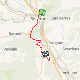
![](/images/other/stat-length.png)
![Randonnée V.T.T. Sisteron - Grande Traversée des PréAlpes à VTT : Sisteron - Aubignosc - Photo](https://media.geolcdn.com/t/1900/400/ext.pjpeg?maxdim=2&url=https%3A%2F%2Fservices.sitytrail.com%2FGeolivesWS%2FDownloadMedia.ashx%3FTrailID%3D104765%26Media%3D8218_2.jpg)
Grande Traversée des PréAlpes à VTT : Sisteron - Aubignosc
tracegps
Utilisateur
![Longueur](/images/other/stat-length.png)
![Altitude max](https://static1.geolcdn.com/siteimages/upload/files/1508320355ic_sort_altitude_max_24dp.png)
![Dénivelé positif](https://static1.geolcdn.com/siteimages/upload/files/1508320355ic_sort_den_pos_24dp.png)
![Km-Effort](/images/other/stat-length.png)
![Altitude min](https://static1.geolcdn.com/siteimages/upload/files/1508320355ic_sort_altitude_min_24dp.png)
![Dénivelé négatif](https://static1.geolcdn.com/siteimages/upload/files/1508320355ic_sort_den_neg_24dp.png)
![Boucle](https://static1.geolcdn.com/siteimages/upload/files/16400158638029165_repeat_loop_refresh_sync_direction_icon.png)
![V.T.T.](https://static1.geolcdn.com/sitytour/trail-icons/202.png)
1h30
Difficulté : Moyen
![Scannez ce code QR pour ouvrir la randonnée dans l'application SityTrail](https://capi.geolives.com/qq0zvz2zws4bq2lad0pu/sitytour/trails/104765/qr.png?size=200)
Application GPS de randonnée GRATUITE
À propos
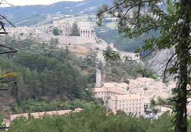
Randonnée V.T.T. de 13 km à découvrir à Provence-Alpes-Côte d'Azur, Alpes-de-Haute-Provence, Sisteron. Cette randonnée est proposée par tracegps.
Description
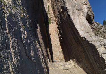
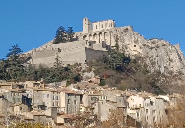
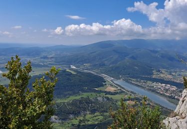
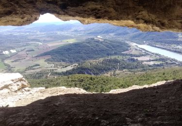
Grande Traversée des Préalpes, les Chemins du Soleil. Parcours officiel labellisé par la Fédération Française de Cyclisme. Plaines fertiles, plateaux arides, collines verdoyantes, torrents imprévisibles, le Val de Durance est une terre de contrastes où se conjuguent l'atmosphère provençale et l'influence vivifiante de la montagne. l'itinéraire sort de l'Espace VTT des Pays du Buech Sisteronnais et entre sur le territoire de la base VTT du Val de Durance. Sur les traces de la Jarlandine, (randonnée VTT locale à ne pas manquer chaque année au printemps au départ de Château Arnoux) le parcours est très varié, vallonné; alternant pistes, sentiers et quelques rares routes peu fréquentées. Consultez toutes les informations sur les hébergements et les services associés sur la fiche du tronçon.
Localisation
Commentaires
Randonnées à proximité
![Randonnée Marche Sisteron - SISTERON . CHAMP BRANCOU . LA COLLE . LE MOLLARD O L S - Photo](https://media.geolcdn.com/t/375/260/cecdacbf-083e-4c48-a080-b152844df49c.jpg&format=jpg&maxdim=2)
![Marche Marche](https://static1.geolcdn.com/sitytour/trail-icons/101.png)
Marche
![](/images/other/stat-length.png)
![](https://static1.geolcdn.com/siteimages/upload/files/16400158638029165_repeat_loop_refresh_sync_direction_icon.png)
![Randonnée Marche Sisteron - Le Trou de l'Argent Via Sisteron - Photo](https://media.geolcdn.com/t/375/260/bfa6b4fb-8efb-4bbe-ae9d-f38ed475646a.jpg&format=jpg&maxdim=2)
![Marche Marche](https://static1.geolcdn.com/sitytour/trail-icons/101.png)
Marche
![](/images/other/stat-length.png)
![](https://static1.geolcdn.com/siteimages/upload/files/16400158638029165_repeat_loop_refresh_sync_direction_icon.png)
![Randonnée Marche Entrepierres - SAINT GENIEZ . LE MOURRE DE GACHE PAR LA FONT DE MEGE N - Photo](https://media.geolcdn.com/t/375/260/5d853fdd-5713-4858-a535-57b1bf5db08d.jpg&format=jpg&maxdim=2)
![Marche Marche](https://static1.geolcdn.com/sitytour/trail-icons/101.png)
Marche
![](/images/other/stat-length.png)
![](https://static1.geolcdn.com/siteimages/upload/files/16400158638029165_repeat_loop_refresh_sync_direction_icon.png)
![Randonnée Marche Sisteron - 05 trop argent 02.08.23 - Photo](https://media.geolcdn.com/t/375/260/2f52f635-2a11-4916-a9f5-f3227f3b1529.jpg&format=jpg&maxdim=2)
![Marche Marche](https://static1.geolcdn.com/sitytour/trail-icons/101.png)
Marche
![](/images/other/stat-length.png)
![](https://static1.geolcdn.com/siteimages/upload/files/16400158638029165_repeat_loop_refresh_sync_direction_icon.png)
![Randonnée Marche Sisteron - SISTERON. SUR LA ROUTE DU TEMPS 2. O L M S - Photo](https://media.geolcdn.com/t/375/260/20c8aa54-ba97-4a73-8287-049a48bb92a8.jpg&format=jpg&maxdim=2)
![Marche Marche](https://static1.geolcdn.com/sitytour/trail-icons/101.png)
Marche
![](/images/other/stat-length.png)
![](https://static1.geolcdn.com/siteimages/upload/files/16400158638029165_repeat_loop_refresh_sync_direction_icon.png)
![Randonnée Marche Sisteron - BEVONS crêtes de Chapage o l s m - Photo](https://media.geolcdn.com/t/375/260/06496741-537d-4e32-9a57-13673b07b6c5.jpg&format=jpg&maxdim=2)
![Marche Marche](https://static1.geolcdn.com/sitytour/trail-icons/101.png)
Marche
![](/images/other/stat-length.png)
![](https://static1.geolcdn.com/siteimages/upload/files/16400158638029165_repeat_loop_refresh_sync_direction_icon.png)
![Randonnée Marche Sisteron - Trou de l'argent - Photo](https://media.geolcdn.com/t/375/260/efd53f67-e8d5-4c71-be71-21c3c1bbbb50.jpg&format=jpg&maxdim=2)
![Marche Marche](https://static1.geolcdn.com/sitytour/trail-icons/101.png)
Marche
![](/images/other/stat-length.png)
![](https://static1.geolcdn.com/siteimages/upload/files/16400158638029165_repeat_loop_refresh_sync_direction_icon.png)
![Randonnée Marche Sisteron - Rocher de Baume - Photo](https://media.geolcdn.com/t/375/260/749307ec-c35c-4209-a01b-d1a95a3c6fd6.jpg&format=jpg&maxdim=2)
![Marche Marche](https://static1.geolcdn.com/sitytour/trail-icons/101.png)
Marche
![](/images/other/stat-length.png)
![](https://static1.geolcdn.com/siteimages/upload/files/16400158638029165_repeat_loop_refresh_sync_direction_icon.png)
![Randonnée Marche Sisteron - SISTERON. Le Mollard . Col S Pierre o n - Photo](https://media.geolcdn.com/t/375/260/439b9630-cce8-40a1-b207-cf2467f89777.jpg&format=jpg&maxdim=2)
![Marche Marche](https://static1.geolcdn.com/sitytour/trail-icons/101.png)
Marche
![](/images/other/stat-length.png)
![](https://static1.geolcdn.com/siteimages/upload/files/16400158638029165_repeat_loop_refresh_sync_direction_icon.png)