![](/images/other/stat-length.png)
![Randonnée Marche Saint-Omer - Clécy 14 km - Photo](https://media.geolcdn.com/t/1900/400/ext.pjpeg?maxdim=2&url=https%3A%2F%2Fservices.sitytrail.com%2FGeolivesWS%2FDownloadMedia.ashx%3FTrailID%3D104649%26Media%3D8037_2.jpg)
Clécy 14 km
tracegps
Utilisateur
![Longueur](/images/other/stat-length.png)
Longueur
14 km
![Altitude max](https://static1.geolcdn.com/siteimages/upload/files/1508320355ic_sort_altitude_max_24dp.png)
Altitude max
290 m
![Dénivelé positif](https://static1.geolcdn.com/siteimages/upload/files/1508320355ic_sort_den_pos_24dp.png)
Dénivelé positif
370 m
![Km-Effort](/images/other/stat-length.png)
Km-Effort
18,9 km
![Altitude min](https://static1.geolcdn.com/siteimages/upload/files/1508320355ic_sort_altitude_min_24dp.png)
Altitude min
38 m
![Dénivelé négatif](https://static1.geolcdn.com/siteimages/upload/files/1508320355ic_sort_den_neg_24dp.png)
Dénivelé négatif
365 m
![Boucle](https://static1.geolcdn.com/siteimages/upload/files/16400158638029165_repeat_loop_refresh_sync_direction_icon.png)
Boucle
Oui
Date de création :
2014-12-10 00:00:00.0
Dernière modification :
2014-12-10 00:00:00.0
![Marche](https://static1.geolcdn.com/sitytour/trail-icons/101.png)
3h00
Difficulté : Moyen
![Scannez ce code QR pour ouvrir la randonnée dans l'application SityTrail](https://capi.geolives.com/qq0zvz2zws4bq2lad0pu/sitytour/trails/104649/qr.png?size=200)
Application GPS de randonnée GRATUITE
À propos
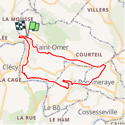
Randonnée Marche de 14 km à découvrir à Normandie, Calvados, Saint-Omer. Cette randonnée est proposée par tracegps.
Description
Départ du site de vol libre sur les hauteurs de St Rémy. Petite boucle très agréable pour une petite randonnée avec un peu de dénivelé. Cela peut faire une petite sortie Jogging un peu physique mais courte. Bonne balade!
Localisation
Pays :
France
Région :
Normandie
Département/Province :
Calvados
Commune :
Saint-Omer
Localité :
Unknown
Départ:(Dec)
Départ:(UTM)
685301 ; 5422776 (30U) N.
Commentaires
Randonnées à proximité
![Randonnée V.T.T. Saint-Omer - Espace VTT FFC de Suisse Normande - Circuit 11 - Saint Omer - Photo](https://media.geolcdn.com/t/375/260/ext.jpg?maxdim=2&url=https%3A%2F%2Fservices.sitytrail.com%2FGeolivesWS%2FDownloadMedia.ashx%3FTrailID%3D106820%26Media%3D11522_1.jpg)
![V.T.T. V.T.T.](https://static1.geolcdn.com/sitytour/trail-icons/202.png)
Espace VTT FFC de Suisse Normande - Circuit 11 - Saint Omer
V.T.T.
Très difficile
(1)
Saint-Omer,
Normandie,
Calvados,
France
![](/images/other/stat-length.png)
25 km | 34 km-effort
3h 0min
![](https://static1.geolcdn.com/siteimages/upload/files/16400158638029165_repeat_loop_refresh_sync_direction_icon.png)
Oui
![Randonnée Marche Le Vey - Clécy - Photo](https://media.geolcdn.com/t/375/260/128372da-8bde-41a3-bf52-ea6a6766f39f.jpg&format=jpg&maxdim=2)
![Marche Marche](https://static1.geolcdn.com/sitytour/trail-icons/101.png)
![Randonnée A pied Le Bô - Des Montagnes de Normandie? - Photo](https://media.geolcdn.com/t/375/260/99446ac7-841c-43b2-a8d0-7ad8496245d0.jpeg&format=jpg&maxdim=2)
![A pied A pied](https://static1.geolcdn.com/sitytour/trail-icons/100.png)
Des Montagnes de Normandie?
A pied
Moyen
Le Bô,
Normandie,
Calvados,
France
![](/images/other/stat-length.png)
15,4 km | 20 km-effort
4h 38min
![](https://static1.geolcdn.com/siteimages/upload/files/16400158638029165_repeat_loop_refresh_sync_direction_icon.png)
Non
![Randonnée A pied Esson - La Chapelle Bonne Nouvelle - Photo](https://media.geolcdn.com/t/375/260/82717480-a9c2-41c9-93af-e42d631dbd18.jpeg&format=jpg&maxdim=2)
![A pied A pied](https://static1.geolcdn.com/sitytour/trail-icons/100.png)
La Chapelle Bonne Nouvelle
A pied
Facile
Esson,
Normandie,
Calvados,
France
![](/images/other/stat-length.png)
9,5 km | 13,3 km-effort
3h 1min
![](https://static1.geolcdn.com/siteimages/upload/files/16400158638029165_repeat_loop_refresh_sync_direction_icon.png)
Oui
![Randonnée A pied La Pommeraye - Les Rochers de Briesvieille - Photo](https://media.geolcdn.com/t/375/260/99446ac7-841c-43b2-a8d0-7ad8496245d0.jpeg&format=jpg&maxdim=2)
![A pied A pied](https://static1.geolcdn.com/sitytour/trail-icons/100.png)
Les Rochers de Briesvieille
A pied
Facile
(1)
La Pommeraye,
Normandie,
Calvados,
France
![](/images/other/stat-length.png)
9,1 km | 12,9 km-effort
2h 55min
![](https://static1.geolcdn.com/siteimages/upload/files/16400158638029165_repeat_loop_refresh_sync_direction_icon.png)
Non
![Randonnée A pied Le Bô - Le Moulin à Papier - Photo](https://media.geolcdn.com/t/375/260/3ac248d0-9006-472c-b1a7-3308f2fe9984.jpeg&format=jpg&maxdim=2)
![A pied A pied](https://static1.geolcdn.com/sitytour/trail-icons/100.png)
Le Moulin à Papier
A pied
Facile
Le Bô,
Normandie,
Calvados,
France
![](/images/other/stat-length.png)
7,1 km | 9,6 km-effort
2h 11min
![](https://static1.geolcdn.com/siteimages/upload/files/16400158638029165_repeat_loop_refresh_sync_direction_icon.png)
Oui
![Randonnée A pied Esson - GRP Tour de la Suisse Normande - Photo](https://media.geolcdn.com/t/375/260/96471841-70b2-445a-bcf9-e6471b393594.jpeg&format=jpg&maxdim=2)
![A pied A pied](https://static1.geolcdn.com/sitytour/trail-icons/100.png)
GRP Tour de la Suisse Normande
A pied
Difficile
Esson,
Normandie,
Calvados,
France
![](/images/other/stat-length.png)
25 km | 35 km-effort
7h 58min
![](https://static1.geolcdn.com/siteimages/upload/files/16400158638029165_repeat_loop_refresh_sync_direction_icon.png)
Non
![Randonnée V.T.T. Saint-Rémy - VTT Suisse Normande N°10 - St Rémy sur Orne - Photo](https://media.geolcdn.com/t/375/260/ext.jpg?maxdim=2&url=https%3A%2F%2Fservices.sitytrail.com%2FGeolivesWS%2FDownloadMedia.ashx%3FTrailID%3D173106%26Media%3D14655_3.jpg)
![V.T.T. V.T.T.](https://static1.geolcdn.com/sitytour/trail-icons/202.png)
VTT Suisse Normande N°10 - St Rémy sur Orne
V.T.T.
Facile
Saint-Rémy,
Normandie,
Calvados,
France
![](/images/other/stat-length.png)
15,8 km | 20 km-effort
1h 30min
![](https://static1.geolcdn.com/siteimages/upload/files/16400158638029165_repeat_loop_refresh_sync_direction_icon.png)
Oui
![Randonnée Marche Clécy - Clecy - Pontecoulant - Photo](https://media.geolcdn.com/t/375/260/b526017d-e01f-4175-825c-320fed21cc05.jpg&format=jpg&maxdim=2)
![Marche Marche](https://static1.geolcdn.com/sitytour/trail-icons/101.png)
Clecy - Pontecoulant
Marche
Difficile
Clécy,
Normandie,
Calvados,
France
![](/images/other/stat-length.png)
11,7 km | 15,9 km-effort
2h 36min
![](https://static1.geolcdn.com/siteimages/upload/files/16400158638029165_repeat_loop_refresh_sync_direction_icon.png)
Non
top!