![](/images/other/stat-length.png)
![Randonnée V.T.T. Orbec - Rando Orbec 22 Km du 14 02 2010 - Photo](https://media.geolcdn.com/t/1900/400/ext.pjpeg?maxdim=2&url=https%3A%2F%2Fstatic1.geolcdn.com%2Fsiteimages%2Fupload%2Ffiles%2F1524743154velo.jpg)
Rando Orbec 22 Km du 14 02 2010
tracegps
Utilisateur
![Longueur](/images/other/stat-length.png)
Longueur
22 km
![Altitude max](https://static1.geolcdn.com/siteimages/upload/files/1508320355ic_sort_altitude_max_24dp.png)
Altitude max
191 m
![Dénivelé positif](https://static1.geolcdn.com/siteimages/upload/files/1508320355ic_sort_den_pos_24dp.png)
Dénivelé positif
329 m
![Km-Effort](/images/other/stat-length.png)
Km-Effort
26 km
![Altitude min](https://static1.geolcdn.com/siteimages/upload/files/1508320355ic_sort_altitude_min_24dp.png)
Altitude min
109 m
![Dénivelé négatif](https://static1.geolcdn.com/siteimages/upload/files/1508320355ic_sort_den_neg_24dp.png)
Dénivelé négatif
327 m
![Boucle](https://static1.geolcdn.com/siteimages/upload/files/16400158638029165_repeat_loop_refresh_sync_direction_icon.png)
Boucle
Oui
Date de création :
2014-12-10 00:00:00.0
Dernière modification :
2014-12-10 00:00:00.0
![V.T.T.](https://static1.geolcdn.com/sitytour/trail-icons/202.png)
2h15
Difficulté : Moyen
![Scannez ce code QR pour ouvrir la randonnée dans l'application SityTrail](https://capi.geolives.com/qq0zvz2zws4bq2lad0pu/sitytour/trails/104530/qr.png?size=200)
Application GPS de randonnée GRATUITE
À propos
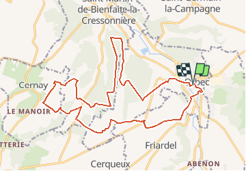
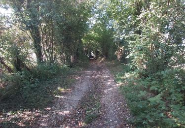
Randonnée V.T.T. de 22 km à découvrir à Normandie, Calvados, Orbec. Cette randonnée est proposée par tracegps.
Description
Randonnée VTT de 22 Kms au départ de la place de la mairie, parcours qui se déroule sur les communes de Saint Martin de Bienfaite, Cernay et Friardel. De beaux passages.
Localisation
Pays :
France
Région :
Normandie
Département/Province :
Calvados
Commune :
Orbec
Localité :
Unknown
Départ:(Dec)
Départ:(UTM)
310333 ; 5433019 (31U) N.
Commentaires
Randonnées à proximité
![Randonnée Vélo Saint-Germain-la-Campagne - Boucle des maisons de maîtres - St-Germain la Campagne - Photo](https://media.geolcdn.com/t/375/260/ext.jpg?maxdim=2&url=https%3A%2F%2Fservices.sitytrail.com%2FGeolivesWS%2FDownloadMedia.ashx%3FTrailID%3D110413%26Media%3D5884_1.jpg)
![Vélo Vélo](https://static1.geolcdn.com/sitytour/trail-icons/200.png)
Boucle des maisons de maîtres - St-Germain la Campagne
Vélo
Moyen
(1)
Saint-Germain-la-Campagne,
Normandie,
Eure,
France
![](/images/other/stat-length.png)
16,3 km | 17,4 km-effort
1h 0min
![](https://static1.geolcdn.com/siteimages/upload/files/16400158638029165_repeat_loop_refresh_sync_direction_icon.png)
Oui
![Randonnée Marche Saint-Martin-de-Bienfaite-la-Cressonnière - saint Martin de bienfaite la cressonnière - Photo](https://media.geolcdn.com/t/375/260/dc2e5291-effa-4a8a-9672-fcdf7b22cd6e.jpg&format=jpg&maxdim=2)
![Marche Marche](https://static1.geolcdn.com/sitytour/trail-icons/101.png)
saint Martin de bienfaite la cressonnière
Marche
Moyen
Saint-Martin-de-Bienfaite-la-Cressonnière,
Normandie,
Calvados,
France
![](/images/other/stat-length.png)
9,6 km | 12,2 km-effort
2h 52min
![](https://static1.geolcdn.com/siteimages/upload/files/16400158638029165_repeat_loop_refresh_sync_direction_icon.png)
Oui
![Randonnée Marche Livarot-Pays-d'Auge - Cerqueux - Photo](https://media.geolcdn.com/t/375/260/2f45acee-67f3-45b7-9c60-c3e7bdd88b3b.jpg&format=jpg&maxdim=2)
![Marche Marche](https://static1.geolcdn.com/sitytour/trail-icons/101.png)
Cerqueux
Marche
Facile
Livarot-Pays-d'Auge,
Normandie,
Calvados,
France
![](/images/other/stat-length.png)
8,2 km | 9,1 km-effort
2h 8min
![](https://static1.geolcdn.com/siteimages/upload/files/16400158638029165_repeat_loop_refresh_sync_direction_icon.png)
Oui
![Randonnée Marche Saint-Germain-la-Campagne - Chemin du Sabot bis - Photo](https://media.geolcdn.com/t/375/260/ext.jpg?maxdim=2&url=https%3A%2F%2Fstatic1.geolcdn.com%2Fsiteimages%2Fupload%2Ffiles%2F1553511878bg_sport_marche.png)
![Marche Marche](https://static1.geolcdn.com/sitytour/trail-icons/101.png)
Chemin du Sabot bis
Marche
Facile
(1)
Saint-Germain-la-Campagne,
Normandie,
Eure,
France
![](/images/other/stat-length.png)
9,8 km | 11,2 km-effort
2h 34min
![](https://static1.geolcdn.com/siteimages/upload/files/16400158638029165_repeat_loop_refresh_sync_direction_icon.png)
Oui
![Randonnée Marche Valorbiquet - Autour de l'Orbiquet - La Chapelle Yvon - Photo](https://media.geolcdn.com/t/375/260/ext.jpg?maxdim=2&url=https%3A%2F%2Fservices.sitytrail.com%2FGeolivesWS%2FDownloadMedia.ashx%3FTrailID%3D129765%26Media%3D13305_4.jpg)
![Marche Marche](https://static1.geolcdn.com/sitytour/trail-icons/101.png)
Autour de l'Orbiquet - La Chapelle Yvon
Marche
Moyen
Valorbiquet,
Normandie,
Calvados,
France
![](/images/other/stat-length.png)
13,8 km | 18,2 km-effort
3h 0min
![](https://static1.geolcdn.com/siteimages/upload/files/16400158638029165_repeat_loop_refresh_sync_direction_icon.png)
Oui
![Randonnée Marche La Chapelle-Gauthier - La Mare Péreuse - La Chapelle-Gauthier - Photo](https://media.geolcdn.com/t/375/260/ext.jpg?maxdim=2&url=https%3A%2F%2Fservices.sitytrail.com%2FGeolivesWS%2FDownloadMedia.ashx%3FTrailID%3D110446%26Media%3D5936_3.jpg)
![Marche Marche](https://static1.geolcdn.com/sitytour/trail-icons/101.png)
La Mare Péreuse - La Chapelle-Gauthier
Marche
Moyen
La Chapelle-Gauthier,
Normandie,
Eure,
France
![](/images/other/stat-length.png)
10,3 km | 11,9 km-effort
2h 45min
![](https://static1.geolcdn.com/siteimages/upload/files/16400158638029165_repeat_loop_refresh_sync_direction_icon.png)
Oui
![Randonnée Marche Livarot-Pays-d'Auge - Cerqueux (14) - Photo](https://media.geolcdn.com/t/375/260/fa66af0f-7d93-434d-88a9-997e464e8dc8.jpg&format=jpg&maxdim=2)
![Marche Marche](https://static1.geolcdn.com/sitytour/trail-icons/101.png)
Cerqueux (14)
Marche
Moyen
Livarot-Pays-d'Auge,
Normandie,
Calvados,
France
![](/images/other/stat-length.png)
15,8 km | 18,1 km-effort
3h 43min
![](https://static1.geolcdn.com/siteimages/upload/files/16400158638029165_repeat_loop_refresh_sync_direction_icon.png)
Oui
![Randonnée Marche Valorbiquet - La Chapelle Yvon - Photo](https://media.geolcdn.com/t/375/260/81604d73-e81e-4ec8-83e6-c5dbf6eea144.jpg&format=jpg&maxdim=2)
![Marche Marche](https://static1.geolcdn.com/sitytour/trail-icons/101.png)
La Chapelle Yvon
Marche
Facile
Valorbiquet,
Normandie,
Calvados,
France
![](/images/other/stat-length.png)
13,4 km | 15,5 km-effort
2h 45min
![](https://static1.geolcdn.com/siteimages/upload/files/16400158638029165_repeat_loop_refresh_sync_direction_icon.png)
Oui
![Randonnée Marche Saint-Germain-la-Campagne - st Germain le campagne - Photo](https://media.geolcdn.com/t/375/260/f555ef23-b15b-473f-8d15-6db03996f0a3.jpg&format=jpg&maxdim=2)
![Marche Marche](https://static1.geolcdn.com/sitytour/trail-icons/101.png)
st Germain le campagne
Marche
Facile
Saint-Germain-la-Campagne,
Normandie,
Eure,
France
![](/images/other/stat-length.png)
8,3 km | 9,3 km-effort
1h 40min
![](https://static1.geolcdn.com/siteimages/upload/files/16400158638029165_repeat_loop_refresh_sync_direction_icon.png)
Oui