![](/images/other/stat-length.png)
![Randonnée V.T.T. Saint-Philbert-des-Champs - Randonnée St Philbert des Champs du 31/01/2010 27 Km - Photo](https://media.geolcdn.com/t/1900/400/ext.pjpeg?maxdim=2&url=https%3A%2F%2Fstatic1.geolcdn.com%2Fsiteimages%2Fupload%2Ffiles%2F1524743154velo.jpg)
Randonnée St Philbert des Champs du 31/01/2010 27 Km
tracegps
Utilisateur
![Longueur](/images/other/stat-length.png)
Longueur
22 km
![Altitude max](https://static1.geolcdn.com/siteimages/upload/files/1508320355ic_sort_altitude_max_24dp.png)
Altitude max
155 m
![Dénivelé positif](https://static1.geolcdn.com/siteimages/upload/files/1508320355ic_sort_den_pos_24dp.png)
Dénivelé positif
316 m
![Km-Effort](/images/other/stat-length.png)
Km-Effort
27 km
![Altitude min](https://static1.geolcdn.com/siteimages/upload/files/1508320355ic_sort_altitude_min_24dp.png)
Altitude min
52 m
![Dénivelé négatif](https://static1.geolcdn.com/siteimages/upload/files/1508320355ic_sort_den_neg_24dp.png)
Dénivelé négatif
319 m
![Boucle](https://static1.geolcdn.com/siteimages/upload/files/16400158638029165_repeat_loop_refresh_sync_direction_icon.png)
Boucle
Oui
Date de création :
2014-12-10 00:00:00.0
Dernière modification :
2014-12-10 00:00:00.0
![V.T.T.](https://static1.geolcdn.com/sitytour/trail-icons/202.png)
2h15
Difficulté : Difficile
![Scannez ce code QR pour ouvrir la randonnée dans l'application SityTrail](https://capi.geolives.com/qq0zvz2zws4bq2lad0pu/sitytour/trails/104482/qr.png?size=200)
Application GPS de randonnée GRATUITE
À propos
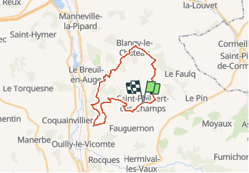
Randonnée V.T.T. de 22 km à découvrir à Normandie, Calvados, Saint-Philbert-des-Champs. Cette randonnée est proposée par tracegps.
Description
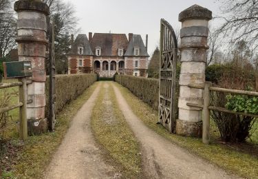
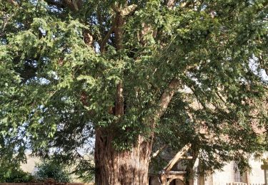
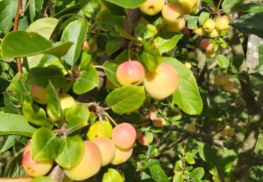
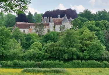
Randonnée de 27 Km au départ de St Philbert des champs, qui passe par Norolle, le Breuil en Auge, Blangy le château et le Brévedent pour se un retour sur St Phibert des Champs. A voit : - Le château de Norolles. - Le centre de Blangy le chateau.
Localisation
Pays :
France
Région :
Normandie
Département/Province :
Calvados
Commune :
Saint-Philbert-des-Champs
Localité :
Unknown
Départ:(Dec)
Départ:(UTM)
302189 ; 5454213 (31U) N.
Commentaires
Randonnées à proximité
![Randonnée Marche Hermival-les-Vaux - Hermival les Vaux - Photo](https://media.geolcdn.com/t/375/260/b55f3f56-db83-4df5-82c4-32855ea6ae90.jpg&format=jpg&maxdim=2)
![Marche Marche](https://static1.geolcdn.com/sitytour/trail-icons/101.png)
Hermival les Vaux
Marche
Moyen
Hermival-les-Vaux,
Normandie,
Calvados,
France
![](/images/other/stat-length.png)
18,2 km | 22 km-effort
5h 12min
![](https://static1.geolcdn.com/siteimages/upload/files/16400158638029165_repeat_loop_refresh_sync_direction_icon.png)
Oui
![Randonnée Marche Saint-Philbert-des-Champs - St Philbert des champs - Photo](https://media.geolcdn.com/t/375/260/e3c7daf5-61fc-4893-b4b5-7e375f43b2d6.jpg&format=jpg&maxdim=2)
![Marche Marche](https://static1.geolcdn.com/sitytour/trail-icons/101.png)
St Philbert des champs
Marche
Facile
(1)
Saint-Philbert-des-Champs,
Normandie,
Calvados,
France
![](/images/other/stat-length.png)
12,5 km | 14,4 km-effort
2h 22min
![](https://static1.geolcdn.com/siteimages/upload/files/16400158638029165_repeat_loop_refresh_sync_direction_icon.png)
Oui
![Randonnée Marche Ouilly-du-Houley - Ouille du Houley - Photo](https://media.geolcdn.com/t/375/260/cd9905a5-9c9c-429d-a6f8-8fbab83e7196.jpg&format=jpg&maxdim=2)
![Marche Marche](https://static1.geolcdn.com/sitytour/trail-icons/101.png)
Ouille du Houley
Marche
Moyen
(1)
Ouilly-du-Houley,
Normandie,
Calvados,
France
![](/images/other/stat-length.png)
11,3 km | 14,4 km-effort
3h 9min
![](https://static1.geolcdn.com/siteimages/upload/files/16400158638029165_repeat_loop_refresh_sync_direction_icon.png)
Oui
![Randonnée Marche Norolles - Norolles - Photo](https://media.geolcdn.com/t/375/260/2f749bdd-b54a-4041-bff6-e6f3481803da.jpg&format=jpg&maxdim=2)
![Marche Marche](https://static1.geolcdn.com/sitytour/trail-icons/101.png)
![Randonnée Marche Saint-Philbert-des-Champs - St Philbert des Champs - Photo](https://media.geolcdn.com/t/375/260/45371fac-3daa-434e-962b-7fddf260621c.jpg&format=jpg&maxdim=2)
![Marche Marche](https://static1.geolcdn.com/sitytour/trail-icons/101.png)
St Philbert des Champs
Marche
Moyen
Saint-Philbert-des-Champs,
Normandie,
Calvados,
France
![](/images/other/stat-length.png)
16,3 km | 18,6 km-effort
3h 12min
![](https://static1.geolcdn.com/siteimages/upload/files/16400158638029165_repeat_loop_refresh_sync_direction_icon.png)
Oui
![Randonnée Marche Hermival-les-Vaux - roque - Photo](https://media.geolcdn.com/t/375/260/ext.jpg?maxdim=2&url=https%3A%2F%2Fservices.sitytrail.com%2FGeolivesWS%2FDownloadMedia.ashx%3FTrailID%3D782956%26Media%3Dfix__20170702122645.jpg)
![Marche Marche](https://static1.geolcdn.com/sitytour/trail-icons/101.png)
roque
Marche
Très facile
Hermival-les-Vaux,
Normandie,
Calvados,
France
![](/images/other/stat-length.png)
23 km | 28 km-effort
6h 0min
![](https://static1.geolcdn.com/siteimages/upload/files/16400158638029165_repeat_loop_refresh_sync_direction_icon.png)
Oui
![Randonnée Marche Hermival-les-Vaux - Hermival les Veaux - Photo](https://media.geolcdn.com/t/375/260/ext.jpg?maxdim=2&url=https%3A%2F%2Fstatic1.geolcdn.com%2Fsiteimages%2Fupload%2Ffiles%2F1553511878bg_sport_marche.png)
![Marche Marche](https://static1.geolcdn.com/sitytour/trail-icons/101.png)
Hermival les Veaux
Marche
Moyen
Hermival-les-Vaux,
Normandie,
Calvados,
France
![](/images/other/stat-length.png)
8,1 km | 10,5 km-effort
2h 23min
![](https://static1.geolcdn.com/siteimages/upload/files/16400158638029165_repeat_loop_refresh_sync_direction_icon.png)
Oui
![Randonnée Marche Ouilly-du-Houley - Ouille du Houley - Photo](https://media.geolcdn.com/t/375/260/72011cf8-89de-43fb-9380-dfdc178cb24c.jpg&format=jpg&maxdim=2)
![Marche Marche](https://static1.geolcdn.com/sitytour/trail-icons/101.png)
Ouille du Houley
Marche
Moyen
Ouilly-du-Houley,
Normandie,
Calvados,
France
![](/images/other/stat-length.png)
9 km | 11,2 km-effort
2h 38min
![](https://static1.geolcdn.com/siteimages/upload/files/16400158638029165_repeat_loop_refresh_sync_direction_icon.png)
Non
![Randonnée 4x4 Ouilly-le-Vicomte - chaudron magique - Photo](https://media.geolcdn.com/t/375/260/ext.jpg?maxdim=2&url=https%3A%2F%2Fstatic1.geolcdn.com%2Fsiteimages%2Fupload%2Ffiles%2F15247431544x4.jpg)
![4x4 4x4](https://static1.geolcdn.com/sitytour/trail-icons/403.png)
chaudron magique
4x4
Très facile
Ouilly-le-Vicomte,
Normandie,
Calvados,
France
![](/images/other/stat-length.png)
104 km | 126 km-effort
7h 33min
![](https://static1.geolcdn.com/siteimages/upload/files/16400158638029165_repeat_loop_refresh_sync_direction_icon.png)
Non