![](/images/other/stat-length.png)
![Randonnée Marche Wancourt - Wancourt - Guémappe - Heninel - Photo](https://media.geolcdn.com/t/1900/400/ext.pjpeg?maxdim=2&url=https%3A%2F%2Fservices.sitytrail.com%2FGeolivesWS%2FDownloadMedia.ashx%3FTrailID%3D104471%26Media%3D7772_1.jpg)
Wancourt - Guémappe - Heninel
tracegps
Utilisateur
![Longueur](/images/other/stat-length.png)
Longueur
10,1 km
![Altitude max](https://static1.geolcdn.com/siteimages/upload/files/1508320355ic_sort_altitude_max_24dp.png)
Altitude max
90 m
![Dénivelé positif](https://static1.geolcdn.com/siteimages/upload/files/1508320355ic_sort_den_pos_24dp.png)
Dénivelé positif
89 m
![Km-Effort](/images/other/stat-length.png)
Km-Effort
11,2 km
![Altitude min](https://static1.geolcdn.com/siteimages/upload/files/1508320355ic_sort_altitude_min_24dp.png)
Altitude min
52 m
![Dénivelé négatif](https://static1.geolcdn.com/siteimages/upload/files/1508320355ic_sort_den_neg_24dp.png)
Dénivelé négatif
90 m
![Boucle](https://static1.geolcdn.com/siteimages/upload/files/16400158638029165_repeat_loop_refresh_sync_direction_icon.png)
Boucle
Oui
Date de création :
2014-12-10 00:00:00.0
Dernière modification :
2014-12-10 00:00:00.0
![Marche](https://static1.geolcdn.com/sitytour/trail-icons/101.png)
2h00
Difficulté : Moyen
![Scannez ce code QR pour ouvrir la randonnée dans l'application SityTrail](https://capi.geolives.com/qq0zvz2zws4bq2lad0pu/sitytour/trails/104471/qr.png?size=200)
Application GPS de randonnée GRATUITE
À propos
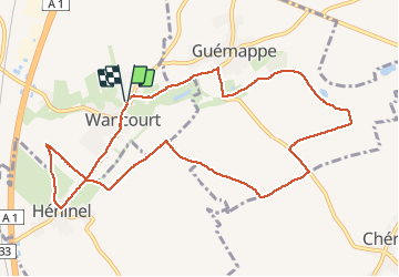
Randonnée Marche de 10,1 km à découvrir à Hauts-de-France, Pas-de-Calais, Wancourt. Cette randonnée est proposée par tracegps.
Description
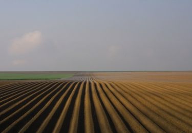
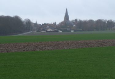
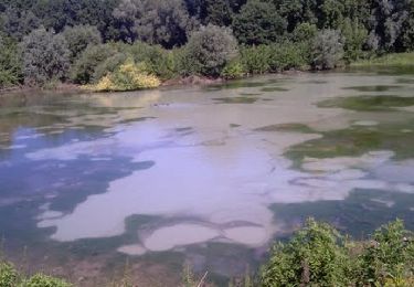
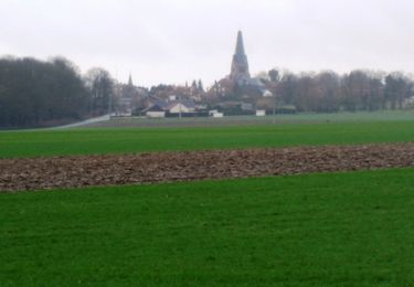
Randonnée au départ de Wancourt qui nous fait longer la petite sensée puis rejoint Heninel en empruntant des chemins de champ.
Localisation
Pays :
France
Région :
Hauts-de-France
Département/Province :
Pas-de-Calais
Commune :
Wancourt
Localité :
Unknown
Départ:(Dec)
Départ:(UTM)
490945 ; 5566335 (31U) N.
Commentaires
Randonnées à proximité
![Randonnée Marche Monchy-le-Preux - Le chemin du Caribou - Monchy le Preux - Photo](https://media.geolcdn.com/t/375/260/ext.jpg?maxdim=2&url=https%3A%2F%2Fservices.sitytrail.com%2FGeolivesWS%2FDownloadMedia.ashx%3FTrailID%3D109907%26Media%3D4917_5.jpg)
![Marche Marche](https://static1.geolcdn.com/sitytour/trail-icons/101.png)
Le chemin du Caribou - Monchy le Preux
Marche
Moyen
(1)
Monchy-le-Preux,
Hauts-de-France,
Pas-de-Calais,
France
![](/images/other/stat-length.png)
9,2 km | 10,1 km-effort
2h 19min
![](https://static1.geolcdn.com/siteimages/upload/files/16400158638029165_repeat_loop_refresh_sync_direction_icon.png)
Oui
![Randonnée Marche Neuville-Vitasse - Le chemin de la crête Picarde - Neuville-Vitasse - Photo](https://media.geolcdn.com/t/375/260/ext.jpg?maxdim=2&url=https%3A%2F%2Fservices.sitytrail.com%2FGeolivesWS%2FDownloadMedia.ashx%3FTrailID%3D110049%26Media%3D5158_4.jpg)
![Marche Marche](https://static1.geolcdn.com/sitytour/trail-icons/101.png)
Le chemin de la crête Picarde - Neuville-Vitasse
Marche
Moyen
Neuville-Vitasse,
Hauts-de-France,
Pas-de-Calais,
France
![](/images/other/stat-length.png)
10,4 km | 11,4 km-effort
2h 40min
![](https://static1.geolcdn.com/siteimages/upload/files/16400158638029165_repeat_loop_refresh_sync_direction_icon.png)
Oui
![Randonnée Marche Chérisy - De Chérisy à Guémappe par les verts Sablons - Photo](https://media.geolcdn.com/t/375/260/ext.jpg?maxdim=2&url=https%3A%2F%2Fservices.sitytrail.com%2FGeolivesWS%2FDownloadMedia.ashx%3FTrailID%3D191417%26Media%3D14999_1.jpg)
![Marche Marche](https://static1.geolcdn.com/sitytour/trail-icons/101.png)
De Chérisy à Guémappe par les verts Sablons
Marche
Moyen
Chérisy,
Hauts-de-France,
Pas-de-Calais,
France
![](/images/other/stat-length.png)
10,3 km | 11,5 km-effort
2h 0min
![](https://static1.geolcdn.com/siteimages/upload/files/16400158638029165_repeat_loop_refresh_sync_direction_icon.png)
Oui
![Randonnée Marche Wancourt - Wancourt - Héninel - Guémappe - Photo](https://media.geolcdn.com/t/375/260/ext.jpg?maxdim=2&url=https%3A%2F%2Fservices.sitytrail.com%2FGeolivesWS%2FDownloadMedia.ashx%3FTrailID%3D129614%26Media%3D13131_2.jpg)
![Marche Marche](https://static1.geolcdn.com/sitytour/trail-icons/101.png)
Wancourt - Héninel - Guémappe
Marche
Moyen
Wancourt,
Hauts-de-France,
Pas-de-Calais,
France
![](/images/other/stat-length.png)
10,4 km | 11,3 km-effort
2h 0min
![](https://static1.geolcdn.com/siteimages/upload/files/16400158638029165_repeat_loop_refresh_sync_direction_icon.png)
Oui
![Randonnée Marche Wancourt - Le chemin de la petite Sensée - Wancourt - Photo](https://media.geolcdn.com/t/375/260/ext.jpg?maxdim=2&url=https%3A%2F%2Fservices.sitytrail.com%2FGeolivesWS%2FDownloadMedia.ashx%3FTrailID%3D110047%26Media%3D5156_2.jpg)
![Marche Marche](https://static1.geolcdn.com/sitytour/trail-icons/101.png)
Le chemin de la petite Sensée - Wancourt
Marche
Moyen
Wancourt,
Hauts-de-France,
Pas-de-Calais,
France
![](/images/other/stat-length.png)
10,9 km | 12,2 km-effort
2h 45min
![](https://static1.geolcdn.com/siteimages/upload/files/16400158638029165_repeat_loop_refresh_sync_direction_icon.png)
Oui
![Randonnée Marche Wancourt - Wancourt - Heninel - Domaine des cascades - Photo](https://media.geolcdn.com/t/375/260/ext.jpg?maxdim=2&url=https%3A%2F%2Fservices.sitytrail.com%2FGeolivesWS%2FDownloadMedia.ashx%3FTrailID%3D106529%26Media%3D11084_1.jpg)
![Marche Marche](https://static1.geolcdn.com/sitytour/trail-icons/101.png)
Wancourt - Heninel - Domaine des cascades
Marche
Moyen
Wancourt,
Hauts-de-France,
Pas-de-Calais,
France
![](/images/other/stat-length.png)
10,8 km | 12,1 km-effort
2h 0min
![](https://static1.geolcdn.com/siteimages/upload/files/16400158638029165_repeat_loop_refresh_sync_direction_icon.png)
Oui
![Randonnée Marche Monchy-le-Preux - Monchy le Preux - Photo](https://media.geolcdn.com/t/375/260/ext.jpg?maxdim=2&url=https%3A%2F%2Fservices.sitytrail.com%2FGeolivesWS%2FDownloadMedia.ashx%3FTrailID%3D106359%26Media%3D10835_1.jpg)
![Marche Marche](https://static1.geolcdn.com/sitytour/trail-icons/101.png)
Monchy le Preux
Marche
Moyen
Monchy-le-Preux,
Hauts-de-France,
Pas-de-Calais,
France
![](/images/other/stat-length.png)
9,7 km | 10,6 km-effort
2h 0min
![](https://static1.geolcdn.com/siteimages/upload/files/16400158638029165_repeat_loop_refresh_sync_direction_icon.png)
Oui
![Randonnée Marche Vis-en-Artois - Vis en Artois - Rémy - Photo](https://media.geolcdn.com/t/375/260/ext.jpg?maxdim=2&url=https%3A%2F%2Fservices.sitytrail.com%2FGeolivesWS%2FDownloadMedia.ashx%3FTrailID%3D106185%26Media%3D10473_1.jpg)
![Marche Marche](https://static1.geolcdn.com/sitytour/trail-icons/101.png)
Vis en Artois - Rémy
Marche
Moyen
Vis-en-Artois,
Hauts-de-France,
Pas-de-Calais,
France
![](/images/other/stat-length.png)
10 km | 11,1 km-effort
2h 0min
![](https://static1.geolcdn.com/siteimages/upload/files/16400158638029165_repeat_loop_refresh_sync_direction_icon.png)
Oui
![Randonnée Marche Pelves - Pelves - Monchy le Preux - Boiry Notre Dame - Photo](https://media.geolcdn.com/t/375/260/ext.jpg?maxdim=2&url=https%3A%2F%2Fservices.sitytrail.com%2FGeolivesWS%2FDownloadMedia.ashx%3FTrailID%3D104118%26Media%3D7188_1.jpg)
![Marche Marche](https://static1.geolcdn.com/sitytour/trail-icons/101.png)
Pelves - Monchy le Preux - Boiry Notre Dame
Marche
Moyen
Pelves,
Hauts-de-France,
Pas-de-Calais,
France
![](/images/other/stat-length.png)
9,9 km | 11,2 km-effort
2h 0min
![](https://static1.geolcdn.com/siteimages/upload/files/16400158638029165_repeat_loop_refresh_sync_direction_icon.png)
Oui