![](/images/other/stat-length.png)
![Randonnée V.T.T. Lourdes - Pic du Jer - Soum de Basta - Photo](https://media.geolcdn.com/t/1900/400/ext.pjpeg?maxdim=2&url=https%3A%2F%2Fservices.sitytrail.com%2FGeolivesWS%2FDownloadMedia.ashx%3FTrailID%3D104457%26Media%3D7734_3.jpg)
Pic du Jer - Soum de Basta
tracegps
Utilisateur
![Longueur](/images/other/stat-length.png)
![Altitude max](https://static1.geolcdn.com/siteimages/upload/files/1508320355ic_sort_altitude_max_24dp.png)
![Dénivelé positif](https://static1.geolcdn.com/siteimages/upload/files/1508320355ic_sort_den_pos_24dp.png)
![Km-Effort](/images/other/stat-length.png)
![Altitude min](https://static1.geolcdn.com/siteimages/upload/files/1508320355ic_sort_altitude_min_24dp.png)
![Dénivelé négatif](https://static1.geolcdn.com/siteimages/upload/files/1508320355ic_sort_den_neg_24dp.png)
![Boucle](https://static1.geolcdn.com/siteimages/upload/files/16400158638029165_repeat_loop_refresh_sync_direction_icon.png)
![V.T.T.](https://static1.geolcdn.com/sitytour/trail-icons/202.png)
3h00
Difficulté : Difficile
![Scannez ce code QR pour ouvrir la randonnée dans l'application SityTrail](https://capi.geolives.com/qq0zvz2zws4bq2lad0pu/sitytour/trails/104457/qr.png?size=200)
Application GPS de randonnée GRATUITE
À propos
Randonnée V.T.T. de 21 km à découvrir à Occitanie, Hautes-Pyrénées, Lourdes. Cette randonnée est proposée par tracegps.
Description
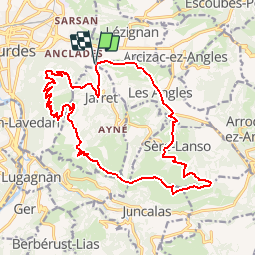
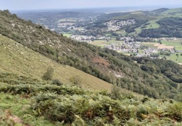
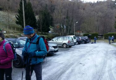
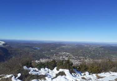
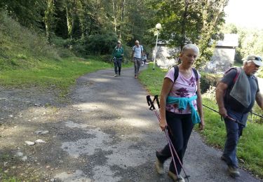
Boucle de 22km pour 1200m dans le piémont pyrénéen avec un passage au pic du Jer qui surplombe la plaine et la ville de Lourdes d'un coté et offre une belle vue des pics de l'autre. Terrain assez sec l'hiver, peu de risque de neige. Attention la dernière descente a partir de Sère (au kilomètre 17) est spéciale type baroud et elle débouche dans la cour d'une ferme (Herrère)
Localisation
Commentaires
Randonnées à proximité
![Randonnée Marche Ousté - SAINT CRÉAC le soum de Trémou reco - Photo](https://media.geolcdn.com/t/375/260/a98a900a-30ee-4911-939d-ee970c5781d5.jpg&format=jpg&maxdim=2)
![Marche Marche](https://static1.geolcdn.com/sitytour/trail-icons/101.png)
Marche
![](/images/other/stat-length.png)
![](https://static1.geolcdn.com/siteimages/upload/files/16400158638029165_repeat_loop_refresh_sync_direction_icon.png)
![Randonnée Marche Ourdis-Cotdoussan - OURDIS Cotdoussan le pic de la clique-fait 933294 (fait le 30/03/2018)](https://media.geolcdn.com/t/375/260/ext.jpg?maxdim=2&url=https%3A%2F%2Fservices.sitytrail.com%2FGeolivesWS%2FDownloadMedia.ashx%3FTrailID%3D933294%26Media%3Dfix__20180330154214.jpg)
![Marche Marche](https://static1.geolcdn.com/sitytour/trail-icons/101.png)
Marche
![](/images/other/stat-length.png)
![](https://static1.geolcdn.com/siteimages/upload/files/16400158638029165_repeat_loop_refresh_sync_direction_icon.png)
![Randonnée Cheval Lourdes - GERMS SUR L'OUSSOUET - Photo](https://media.geolcdn.com/t/375/260/ext.jpg?maxdim=2&url=https%3A%2F%2Fstatic1.geolcdn.com%2Fsiteimages%2Fupload%2Ffiles%2F1524743154cheval.jpg)
![Cheval Cheval](https://static1.geolcdn.com/sitytour/trail-icons/300.png)
Cheval
![](/images/other/stat-length.png)
![](https://static1.geolcdn.com/siteimages/upload/files/16400158638029165_repeat_loop_refresh_sync_direction_icon.png)
![Randonnée Marche Lourdes - 2023 10 09 CHEMIN du PIÉMONT PYRÉNÉEN - 17ème étape : Lourdes - Saint-Pé-de Bigorre - Lestelle-Bétharram - Photo](https://media.geolcdn.com/t/375/260/442ca37b-5bdb-4d68-8d03-9f9f787ba05d.jpg&format=jpg&maxdim=2)
![Marche Marche](https://static1.geolcdn.com/sitytour/trail-icons/101.png)
Marche
![](/images/other/stat-length.png)
![](https://static1.geolcdn.com/siteimages/upload/files/16400158638029165_repeat_loop_refresh_sync_direction_icon.png)
![Randonnée Marche Lourdes - 65-lourdes-pic-jer-via-AYNE-14km-450m - Photo](https://media.geolcdn.com/t/375/260/edfe9827-bfa7-45cb-8900-3f3f61682c3a.jpg&format=jpg&maxdim=2)
![Marche Marche](https://static1.geolcdn.com/sitytour/trail-icons/101.png)
Marche
![](/images/other/stat-length.png)
![](https://static1.geolcdn.com/siteimages/upload/files/16400158638029165_repeat_loop_refresh_sync_direction_icon.png)
![Randonnée Marche Lourdes - LOURDES la boucle du petit Jer G4](https://media.geolcdn.com/t/375/260/b5657c6d-2945-414a-9faa-597eb5ff020c.jpg&format=jpg&maxdim=2)
![Marche Marche](https://static1.geolcdn.com/sitytour/trail-icons/101.png)
Marche
![](/images/other/stat-length.png)
![](https://static1.geolcdn.com/siteimages/upload/files/16400158638029165_repeat_loop_refresh_sync_direction_icon.png)
![Randonnée Marche Saint-Créac - SAINT CRÉAC soum de Tremou BF de Guy G3 - Photo](https://media.geolcdn.com/t/375/260/9d594086-7588-47fe-9248-f3484a1a71e9.jpg&format=jpg&maxdim=2)
![Marche Marche](https://static1.geolcdn.com/sitytour/trail-icons/101.png)
Marche
![](/images/other/stat-length.png)
![](https://static1.geolcdn.com/siteimages/upload/files/16400158638029165_repeat_loop_refresh_sync_direction_icon.png)
![Randonnée Marche Lourdes - Pic du Jer - Photo](https://media.geolcdn.com/t/375/260/2ec92ca4-bc0f-4457-b492-963919b92b1f.jpg&format=jpg&maxdim=2)
![Marche Marche](https://static1.geolcdn.com/sitytour/trail-icons/101.png)
Marche
![](/images/other/stat-length.png)
![](https://static1.geolcdn.com/siteimages/upload/files/16400158638029165_repeat_loop_refresh_sync_direction_icon.png)
![Randonnée Marche Lourdes - LOURDES le Beout autrement 2955824 - Photo](https://media.geolcdn.com/t/375/260/988997aa-10d6-47b9-8be8-5078e4de55b9.jpg&format=jpg&maxdim=2)
![Marche Marche](https://static1.geolcdn.com/sitytour/trail-icons/101.png)
Marche
![](/images/other/stat-length.png)
![](https://static1.geolcdn.com/siteimages/upload/files/16400158638029165_repeat_loop_refresh_sync_direction_icon.png)