![](/images/other/stat-length.png)
![Randonnée V.T.T. Bagnoles-de-l'Orne-Normandie - Les Arbres remarquables de Bagnoles de l'Orne - Photo](https://media.geolcdn.com/t/1900/400/ext.pjpeg?maxdim=2&url=https%3A%2F%2Fstatic1.geolcdn.com%2Fsiteimages%2Fupload%2Ffiles%2F1524743154velo.jpg)
Les Arbres remarquables de Bagnoles de l'Orne
tracegps
Utilisateur
![Longueur](/images/other/stat-length.png)
![Altitude max](https://static1.geolcdn.com/siteimages/upload/files/1508320355ic_sort_altitude_max_24dp.png)
![Dénivelé positif](https://static1.geolcdn.com/siteimages/upload/files/1508320355ic_sort_den_pos_24dp.png)
![Km-Effort](/images/other/stat-length.png)
![Altitude min](https://static1.geolcdn.com/siteimages/upload/files/1508320355ic_sort_altitude_min_24dp.png)
![Dénivelé négatif](https://static1.geolcdn.com/siteimages/upload/files/1508320355ic_sort_den_neg_24dp.png)
![Boucle](https://static1.geolcdn.com/siteimages/upload/files/16400158638029165_repeat_loop_refresh_sync_direction_icon.png)
![V.T.T.](https://static1.geolcdn.com/sitytour/trail-icons/202.png)
19m
Difficulté : Moyen
![Scannez ce code QR pour ouvrir la randonnée dans l'application SityTrail](https://capi.geolives.com/qq0zvz2zws4bq2lad0pu/sitytour/trails/104392/qr.png?size=200)
Application GPS de randonnée GRATUITE
À propos
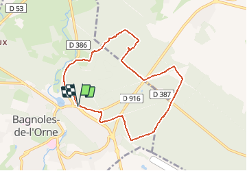
Randonnée V.T.T. de 7,8 km à découvrir à Normandie, Orne, Bagnoles-de-l'Orne-Normandie. Cette randonnée est proposée par tracegps.
Description
Belle balade en sous bois alternant petits sentiers et grandes sommières. Découverte en chemin des deux arbres remarquables de la forêt domaniale des Andaines: le Chêne Hyppolite et le Hêtre de la Vierge, tous deux sources de légendes. Traversée difficile de D916 randonnée très jolie au printemps (floraison des jacynthes des bois) et à l'automne (possibilité de cueillir des champignons). Location possible de GPS à l'Office de Tourisme de Bagnoles de l'Orne et sur www.label-nature.net
Localisation
Commentaires
Randonnées à proximité
![Randonnée A pied Rives-d'Andaine - Sentier des Templiers - Photo](https://media.geolcdn.com/t/375/260/7f8f2913-590f-4c31-b4e9-64954dd46906.jpeg&format=jpg&maxdim=2)
![A pied A pied](https://static1.geolcdn.com/sitytour/trail-icons/100.png)
A pied
![](/images/other/stat-length.png)
![](https://static1.geolcdn.com/siteimages/upload/files/16400158638029165_repeat_loop_refresh_sync_direction_icon.png)
![Randonnée Marche Bagnoles-de-l'Orne-Normandie - Saint Ortaire - Photo](https://media.geolcdn.com/t/375/260/ext.jpg?maxdim=2&url=https%3A%2F%2Fstatic1.geolcdn.com%2Fsiteimages%2Fupload%2Ffiles%2F1553511878bg_sport_marche.png)
![Marche Marche](https://static1.geolcdn.com/sitytour/trail-icons/101.png)
Marche
![](/images/other/stat-length.png)
![](https://static1.geolcdn.com/siteimages/upload/files/16400158638029165_repeat_loop_refresh_sync_direction_icon.png)
![Randonnée Marche Bagnoles-de-l'Orne-Normandie - Forêt d'Andaine - Photo](https://media.geolcdn.com/t/375/260/4445009f-5e34-4cf0-9270-1184d385e215.jpg&format=jpg&maxdim=2)
![Marche Marche](https://static1.geolcdn.com/sitytour/trail-icons/101.png)
Marche
![](/images/other/stat-length.png)
![](https://static1.geolcdn.com/siteimages/upload/files/16400158638029165_repeat_loop_refresh_sync_direction_icon.png)
![Randonnée A pied Bagnoles-de-l'Orne-Normandie - Les Arbres remarquables de Bagnoles-de-l'Orne - Photo](https://media.geolcdn.com/t/375/260/3f5af4f6-b5c2-468d-a381-1ea1dcd7f8d4.jpeg&format=jpg&maxdim=2)
![A pied A pied](https://static1.geolcdn.com/sitytour/trail-icons/100.png)
A pied
![](/images/other/stat-length.png)
![](https://static1.geolcdn.com/siteimages/upload/files/16400158638029165_repeat_loop_refresh_sync_direction_icon.png)
![Randonnée A pied Bagnoles-de-l'Orne-Normandie - Bagnoles-de-l'Orne - Photo](https://media.geolcdn.com/t/375/260/352c0479-80dd-4a7d-ade5-52d7e1895bb3.jpeg&format=jpg&maxdim=2)
![A pied A pied](https://static1.geolcdn.com/sitytour/trail-icons/100.png)
A pied
![](/images/other/stat-length.png)
![](https://static1.geolcdn.com/siteimages/upload/files/16400158638029165_repeat_loop_refresh_sync_direction_icon.png)
![Randonnée A pied La Ferté-Macé - Circuit des Bornes Cavalières - Photo](https://media.geolcdn.com/t/375/260/ae4572a0-be41-42e4-9cb7-abcf5f5905ac.jpeg&format=jpg&maxdim=2)
![A pied A pied](https://static1.geolcdn.com/sitytour/trail-icons/100.png)
A pied
![](/images/other/stat-length.png)
![](https://static1.geolcdn.com/siteimages/upload/files/16400158638029165_repeat_loop_refresh_sync_direction_icon.png)
![Randonnée V.T.C. Bagnoles-de-l'Orne-Normandie - bagnoles de l'ore - Photo](https://media.geolcdn.com/t/375/260/4eea9336-edc2-458e-9d5f-3a5eced18dc8.jpg&format=jpg&maxdim=2)
![V.T.C. V.T.C.](https://static1.geolcdn.com/sitytour/trail-icons/203.png)
V.T.C.
![](/images/other/stat-length.png)
![](https://static1.geolcdn.com/siteimages/upload/files/16400158638029165_repeat_loop_refresh_sync_direction_icon.png)
![Randonnée Marche Magny-le-Désert - Andaines - Villiers - Photo](https://media.geolcdn.com/t/375/260/ext.jpg?maxdim=2&url=https%3A%2F%2Fstatic1.geolcdn.com%2Fsiteimages%2Fupload%2Ffiles%2F1553511878bg_sport_marche.png)
![Marche Marche](https://static1.geolcdn.com/sitytour/trail-icons/101.png)
Marche
![](/images/other/stat-length.png)
![](https://static1.geolcdn.com/siteimages/upload/files/16400158638029165_repeat_loop_refresh_sync_direction_icon.png)
![Randonnée Marche Bagnoles-de-l'Orne-Normandie - Bagnoles de l' orne - Photo](https://media.geolcdn.com/t/375/260/fa0660f3-37d7-48ea-8a93-ad724fc5fdf8.jpg&format=jpg&maxdim=2)
![Marche Marche](https://static1.geolcdn.com/sitytour/trail-icons/101.png)
Marche
![](/images/other/stat-length.png)
![](https://static1.geolcdn.com/siteimages/upload/files/16400158638029165_repeat_loop_refresh_sync_direction_icon.png)