![](/images/other/stat-length.png)
![Randonnée Marche Berneville - Le sentier des Tourelles - Berneville - Photo](https://media.geolcdn.com/t/1900/400/ext.pjpeg?maxdim=2&url=https%3A%2F%2Fservices.sitytrail.com%2FGeolivesWS%2FDownloadMedia.ashx%3FTrailID%3D104252%26Media%3D7447_4.jpg)
Le sentier des Tourelles - Berneville
tracegps
Utilisateur
![Longueur](/images/other/stat-length.png)
Longueur
5,8 km
![Altitude max](https://static1.geolcdn.com/siteimages/upload/files/1508320355ic_sort_altitude_max_24dp.png)
Altitude max
114 m
![Dénivelé positif](https://static1.geolcdn.com/siteimages/upload/files/1508320355ic_sort_den_pos_24dp.png)
Dénivelé positif
55 m
![Km-Effort](/images/other/stat-length.png)
Km-Effort
6,6 km
![Altitude min](https://static1.geolcdn.com/siteimages/upload/files/1508320355ic_sort_altitude_min_24dp.png)
Altitude min
85 m
![Dénivelé négatif](https://static1.geolcdn.com/siteimages/upload/files/1508320355ic_sort_den_neg_24dp.png)
Dénivelé négatif
56 m
![Boucle](https://static1.geolcdn.com/siteimages/upload/files/16400158638029165_repeat_loop_refresh_sync_direction_icon.png)
Boucle
Oui
Date de création :
2014-12-10 00:00:00.0
Dernière modification :
2014-12-10 00:00:00.0
![Marche](https://static1.geolcdn.com/sitytour/trail-icons/101.png)
1h30
Difficulté : Facile
![Scannez ce code QR pour ouvrir la randonnée dans l'application SityTrail](https://capi.geolives.com/qq0zvz2zws4bq2lad0pu/sitytour/trails/104252/qr.png?size=200)
Application GPS de randonnée GRATUITE
À propos
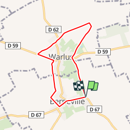
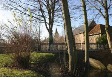
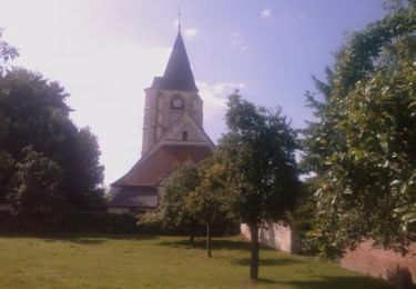
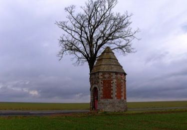
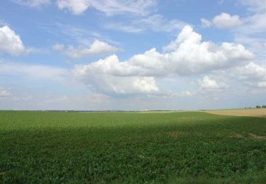
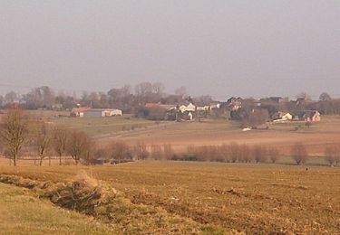
Randonnée Marche de 5,8 km à découvrir à Hauts-de-France, Pas-de-Calais, Berneville. Cette randonnée est proposée par tracegps.
Description
Circuit proposé par la Communauté de Communes des Vertes Vallées. Départ du parking de la salle des fêtes de Berneville. Retrouvez le circuit sur le site de la Communauté de Communes.
Localisation
Pays :
France
Région :
Hauts-de-France
Département/Province :
Pas-de-Calais
Commune :
Berneville
Localité :
Unknown
Départ:(Dec)
Départ:(UTM)
477009 ; 5568345 (31U) N.
Commentaires
Randonnées à proximité
![Randonnée Marche Dainville - le Crinchon - Photo](https://media.geolcdn.com/t/375/260/ext.jpg?maxdim=2&url=https%3A%2F%2Fservices.sitytrail.com%2FGeolivesWS%2FDownloadMedia.ashx%3FTrailID%3D537537%26Media%3Dfix__20160313105733.jpg)
![Marche Marche](https://static1.geolcdn.com/sitytour/trail-icons/101.png)
le Crinchon
Marche
Facile
Dainville,
Hauts-de-France,
Pas-de-Calais,
France
![](/images/other/stat-length.png)
24 km | 26 km-effort
5h 18min
![](https://static1.geolcdn.com/siteimages/upload/files/16400158638029165_repeat_loop_refresh_sync_direction_icon.png)
Oui
![Randonnée Marche Dainville - le Crinchon - Photo](https://media.geolcdn.com/t/375/260/ext.jpg?maxdim=2&url=https%3A%2F%2Fservices.sitytrail.com%2FGeolivesWS%2FDownloadMedia.ashx%3FTrailID%3D537535%26Media%3Dfix__20160313154016.jpg)
![Marche Marche](https://static1.geolcdn.com/sitytour/trail-icons/101.png)
le Crinchon
Marche
Facile
Dainville,
Hauts-de-France,
Pas-de-Calais,
France
![](/images/other/stat-length.png)
24 km | 26 km-effort
5h 18min
![](https://static1.geolcdn.com/siteimages/upload/files/16400158638029165_repeat_loop_refresh_sync_direction_icon.png)
Oui
![Randonnée Marche Wailly - Chemin du Belloy - Wailly - Photo](https://media.geolcdn.com/t/375/260/ext.jpg?maxdim=2&url=https%3A%2F%2Fservices.sitytrail.com%2FGeolivesWS%2FDownloadMedia.ashx%3FTrailID%3D110057%26Media%3D5177_3.jpg)
![Marche Marche](https://static1.geolcdn.com/sitytour/trail-icons/101.png)
Chemin du Belloy - Wailly
Marche
Moyen
Wailly,
Hauts-de-France,
Pas-de-Calais,
France
![](/images/other/stat-length.png)
9,6 km | 10,6 km-effort
2h 25min
![](https://static1.geolcdn.com/siteimages/upload/files/16400158638029165_repeat_loop_refresh_sync_direction_icon.png)
Oui
![Randonnée Marche Simencourt - Sentier du bout du monde - Simencourt - Photo](https://media.geolcdn.com/t/375/260/ext.jpg?maxdim=2&url=https%3A%2F%2Fservices.sitytrail.com%2FGeolivesWS%2FDownloadMedia.ashx%3FTrailID%3D104253%26Media%3D7448_5.jpg)
![Marche Marche](https://static1.geolcdn.com/sitytour/trail-icons/101.png)
Sentier du bout du monde - Simencourt
Marche
Moyen
Simencourt,
Hauts-de-France,
Pas-de-Calais,
France
![](/images/other/stat-length.png)
9,1 km | 10,3 km-effort
2h 15min
![](https://static1.geolcdn.com/siteimages/upload/files/16400158638029165_repeat_loop_refresh_sync_direction_icon.png)
Oui
![Randonnée Marche Duisans - De Duisans à Warlus via Wagnonlieu - Photo](https://media.geolcdn.com/t/375/260/ext.jpg?maxdim=2&url=https%3A%2F%2Fservices.sitytrail.com%2FGeolivesWS%2FDownloadMedia.ashx%3FTrailID%3D118679%26Media%3D12846_1.jpg)
![Marche Marche](https://static1.geolcdn.com/sitytour/trail-icons/101.png)
De Duisans à Warlus via Wagnonlieu
Marche
Moyen
Duisans,
Hauts-de-France,
Pas-de-Calais,
France
![](/images/other/stat-length.png)
9,5 km | 10,6 km-effort
2h 0min
![](https://static1.geolcdn.com/siteimages/upload/files/16400158638029165_repeat_loop_refresh_sync_direction_icon.png)
Oui
![Randonnée Marche Dainville - Chemin le Wagnonlieu - Dainville - Photo](https://media.geolcdn.com/t/375/260/ext.jpg?maxdim=2&url=https%3A%2F%2Fservices.sitytrail.com%2FGeolivesWS%2FDownloadMedia.ashx%3FTrailID%3D110050%26Media%3D5159_2.jpg)
![Marche Marche](https://static1.geolcdn.com/sitytour/trail-icons/101.png)
Chemin le Wagnonlieu - Dainville
Marche
Difficile
Dainville,
Hauts-de-France,
Pas-de-Calais,
France
![](/images/other/stat-length.png)
12,7 km | 14 km-effort
3h 10min
![](https://static1.geolcdn.com/siteimages/upload/files/16400158638029165_repeat_loop_refresh_sync_direction_icon.png)
Oui
![Randonnée Marche Simencourt - Simencourt - Gouy en Artois - Photo](https://media.geolcdn.com/t/375/260/ext.jpg?maxdim=2&url=https%3A%2F%2Fservices.sitytrail.com%2FGeolivesWS%2FDownloadMedia.ashx%3FTrailID%3D106278%26Media%3D10636_1.jpg)
![Marche Marche](https://static1.geolcdn.com/sitytour/trail-icons/101.png)
Simencourt - Gouy en Artois
Marche
Moyen
Simencourt,
Hauts-de-France,
Pas-de-Calais,
France
![](/images/other/stat-length.png)
9,3 km | 10,3 km-effort
2h 0min
![](https://static1.geolcdn.com/siteimages/upload/files/16400158638029165_repeat_loop_refresh_sync_direction_icon.png)
Oui
![Randonnée Marche Berneville - Berneville - Beaumetz - Monchiet - Simencourt - Photo](https://media.geolcdn.com/t/375/260/ext.jpg?maxdim=2&url=https%3A%2F%2Fservices.sitytrail.com%2FGeolivesWS%2FDownloadMedia.ashx%3FTrailID%3D106081%26Media%3D10264_1.jpg)
![Marche Marche](https://static1.geolcdn.com/sitytour/trail-icons/101.png)
Berneville - Beaumetz - Monchiet - Simencourt
Marche
Moyen
Berneville,
Hauts-de-France,
Pas-de-Calais,
France
![](/images/other/stat-length.png)
10,8 km | 12,2 km-effort
2h 0min
![](https://static1.geolcdn.com/siteimages/upload/files/16400158638029165_repeat_loop_refresh_sync_direction_icon.png)
Oui
![Randonnée Marche Montenescourt - Montenescourt - Gouves - Wanquetin - Photo](https://media.geolcdn.com/t/375/260/ext.jpg?maxdim=2&url=https%3A%2F%2Fservices.sitytrail.com%2FGeolivesWS%2FDownloadMedia.ashx%3FTrailID%3D105946%26Media%3D9997_1.jpg)
![Marche Marche](https://static1.geolcdn.com/sitytour/trail-icons/101.png)
Montenescourt - Gouves - Wanquetin
Marche
Moyen
Montenescourt,
Hauts-de-France,
Pas-de-Calais,
France
![](/images/other/stat-length.png)
10,6 km | 11,9 km-effort
2h 0min
![](https://static1.geolcdn.com/siteimages/upload/files/16400158638029165_repeat_loop_refresh_sync_direction_icon.png)
Oui