![](/images/other/stat-length.png)
![Randonnée V.T.T. Cesson-Sévigné - Rennes - La Bouexière - Bois de Champaufour - Petite Saudraie - Placis Vert - Photo](https://media.geolcdn.com/t/1900/400/ext.pjpeg?maxdim=2&url=https%3A%2F%2Fstatic1.geolcdn.com%2Fsiteimages%2Fupload%2Ffiles%2F1524743154velo.jpg)
Rennes - La Bouexière - Bois de Champaufour - Petite Saudraie - Placis Vert
tracegps
Utilisateur
![Longueur](/images/other/stat-length.png)
![Altitude max](https://static1.geolcdn.com/siteimages/upload/files/1508320355ic_sort_altitude_max_24dp.png)
![Dénivelé positif](https://static1.geolcdn.com/siteimages/upload/files/1508320355ic_sort_den_pos_24dp.png)
![Km-Effort](/images/other/stat-length.png)
![Altitude min](https://static1.geolcdn.com/siteimages/upload/files/1508320355ic_sort_altitude_min_24dp.png)
![Dénivelé négatif](https://static1.geolcdn.com/siteimages/upload/files/1508320355ic_sort_den_neg_24dp.png)
![Boucle](https://static1.geolcdn.com/siteimages/upload/files/16400158638029165_repeat_loop_refresh_sync_direction_icon.png)
![V.T.T.](https://static1.geolcdn.com/sitytour/trail-icons/202.png)
1h00
Difficulté : Facile
![Scannez ce code QR pour ouvrir la randonnée dans l'application SityTrail](https://capi.geolives.com/qq0zvz2zws4bq2lad0pu/sitytour/trails/104060/qr.png?size=200)
Application GPS de randonnée GRATUITE
À propos
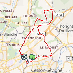
Randonnée V.T.T. de 16,8 km à découvrir à Bretagne, Ille-et-Vilaine, Cesson-Sévigné. Cette randonnée est proposée par tracegps.
Description
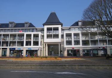
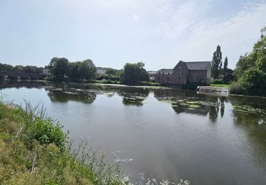
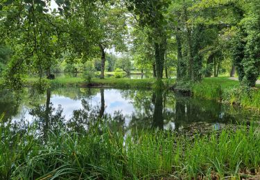
Boucle au départ de Orange FT Cesson. Un début bitumeux par les petites routes pour rejoindre au bout de 4kms le GR. Passage large et caillouteux, aucune difficulté. Passages agréables en sous-bois. Traversée du bois de Champaufourt par la route forestière. Portage du vélo en sortie si barrière fermée. Direction la forêt de Rennes par la route puis chemin du Gentil. Passage à coté de fermes. Retour par la route. Circuit agréable , très facile orienté balade. Aucune difficulté technique.
Localisation
Commentaires
Randonnées à proximité
![Randonnée A pied Saint-Grégoire - Circuit de la Boutière - Photo](https://media.geolcdn.com/t/375/260/be6e7bb0-1772-48a6-9f30-2bc59080eacb.jpeg&format=jpg&maxdim=2)
![A pied A pied](https://static1.geolcdn.com/sitytour/trail-icons/100.png)
A pied
![](/images/other/stat-length.png)
![](https://static1.geolcdn.com/siteimages/upload/files/16400158638029165_repeat_loop_refresh_sync_direction_icon.png)
![Randonnée A pied Rennes - Circuit des Louvries - Photo](https://media.geolcdn.com/t/375/260/df10b53e-816c-4112-9887-ffbc2c82646e.jpeg&format=jpg&maxdim=2)
![A pied A pied](https://static1.geolcdn.com/sitytour/trail-icons/100.png)
A pied
![](/images/other/stat-length.png)
![](https://static1.geolcdn.com/siteimages/upload/files/16400158638029165_repeat_loop_refresh_sync_direction_icon.png)
![Randonnée A pied Rennes - La balade à André - Photo](https://media.geolcdn.com/t/375/260/21bf6cca-cebe-47ea-8c50-7b46a79e5fa3.jpeg&format=jpg&maxdim=2)
![A pied A pied](https://static1.geolcdn.com/sitytour/trail-icons/100.png)
A pied
![](/images/other/stat-length.png)
![](https://static1.geolcdn.com/siteimages/upload/files/16400158638029165_repeat_loop_refresh_sync_direction_icon.png)
![Randonnée A pied Cesson-Sévigné - Parcs et jardins - Photo](https://media.geolcdn.com/t/375/260/037007ff-9a46-424d-a033-bc4b6ff71a6a.jpeg&format=jpg&maxdim=2)
![A pied A pied](https://static1.geolcdn.com/sitytour/trail-icons/100.png)
A pied
![](/images/other/stat-length.png)
![](https://static1.geolcdn.com/siteimages/upload/files/16400158638029165_repeat_loop_refresh_sync_direction_icon.png)
![Randonnée Marche Cesson-Sévigné - Cesson Sévigné - Photo](https://media.geolcdn.com/t/375/260/ext.jpg?maxdim=2&url=https%3A%2F%2Fstatic1.geolcdn.com%2Fsiteimages%2Fupload%2Ffiles%2F1553511878bg_sport_marche.png)
![Marche Marche](https://static1.geolcdn.com/sitytour/trail-icons/101.png)
Marche
![](/images/other/stat-length.png)
![](https://static1.geolcdn.com/siteimages/upload/files/16400158638029165_repeat_loop_refresh_sync_direction_icon.png)
![Randonnée Marche Rennes - La promenade Georges Brassens et des Bonnets Rouges - Rennes - Photo](https://media.geolcdn.com/t/375/260/ext.jpg?maxdim=2&url=https%3A%2F%2Fservices.sitytrail.com%2FGeolivesWS%2FDownloadMedia.ashx%3FTrailID%3D191412%26Media%3D14992_6.jpg)
![Marche Marche](https://static1.geolcdn.com/sitytour/trail-icons/101.png)
Marche
![](/images/other/stat-length.png)
![](https://static1.geolcdn.com/siteimages/upload/files/16400158638029165_repeat_loop_refresh_sync_direction_icon.png)
![Randonnée A pied Rennes - RENNES : street art raccourci le 18/11/2024 - Photo](https://media.geolcdn.com/t/375/260/51742e12-aee2-4c99-96cd-a0fc410ef54f.jpg&format=jpg&maxdim=2)
![A pied A pied](https://static1.geolcdn.com/sitytour/trail-icons/100.png)
A pied
![](/images/other/stat-length.png)
![](https://static1.geolcdn.com/siteimages/upload/files/16400158638029165_repeat_loop_refresh_sync_direction_icon.png)
![Randonnée Vélo électrique Rennes - Rennes à Guipry-Messac - Photo](https://media.geolcdn.com/t/375/260/2b36141b-c92e-475f-a12d-aab1f02c06c0.jpg&format=jpg&maxdim=2)
![Vélo électrique Vélo électrique](https://static1.geolcdn.com/sitytour/trail-icons/205.png)
Vélo électrique
![](/images/other/stat-length.png)
![](https://static1.geolcdn.com/siteimages/upload/files/16400158638029165_repeat_loop_refresh_sync_direction_icon.png)
![Randonnée Marche Cesson-Sévigné - cesson - Photo](https://media.geolcdn.com/t/375/260/031b7295-c682-47d4-9915-29014b9b2945.jpg&format=jpg&maxdim=2)
![Marche Marche](https://static1.geolcdn.com/sitytour/trail-icons/101.png)
Marche
![](/images/other/stat-length.png)
![](https://static1.geolcdn.com/siteimages/upload/files/16400158638029165_repeat_loop_refresh_sync_direction_icon.png)