![](/images/other/stat-length.png)
![Randonnée Marche Oiartzun - Les Mines d'Arditurri - Photo](https://media.geolcdn.com/t/1900/400/ext.pjpeg?maxdim=2&url=https%3A%2F%2Fstatic1.geolcdn.com%2Fsiteimages%2Fupload%2Ffiles%2F1553511878bg_sport_marche.png)
Les Mines d'Arditurri
georgein
Utilisateur
![Longueur](/images/other/stat-length.png)
Longueur
9,4 km
![Altitude max](https://static1.geolcdn.com/siteimages/upload/files/1508320355ic_sort_altitude_max_24dp.png)
Altitude max
398 m
![Dénivelé positif](https://static1.geolcdn.com/siteimages/upload/files/1508320355ic_sort_den_pos_24dp.png)
Dénivelé positif
436 m
![Km-Effort](/images/other/stat-length.png)
Km-Effort
15,3 km
![Altitude min](https://static1.geolcdn.com/siteimages/upload/files/1508320355ic_sort_altitude_min_24dp.png)
Altitude min
90 m
![Dénivelé négatif](https://static1.geolcdn.com/siteimages/upload/files/1508320355ic_sort_den_neg_24dp.png)
Dénivelé négatif
435 m
![Boucle](https://static1.geolcdn.com/siteimages/upload/files/16400158638029165_repeat_loop_refresh_sync_direction_icon.png)
Boucle
Oui
Date de création :
2019-08-04 09:20:33.408
Dernière modification :
2020-01-31 20:30:04.925
![Marche](https://static1.geolcdn.com/sitytour/trail-icons/101.png)
3h07
Difficulté : Inconnu
![Scannez ce code QR pour ouvrir la randonnée dans l'application SityTrail](https://capi.geolives.com/qq0zvz2zws4bq2lad0pu/sitytour/trails/1040046/qr.png?size=200)
Application GPS de randonnée GRATUITE
À propos
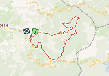
Randonnée Marche de 9,4 km à découvrir à Pays basque autonome, Guipuscoa, Oiartzun. Cette randonnée est proposée par georgein.
Description
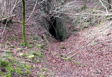
tite balade autour des mines d'Arditurri.
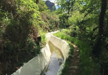
Très jolis sous-bois avec présence de nombreux petits cours d'eau et de sentiers.
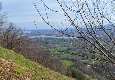
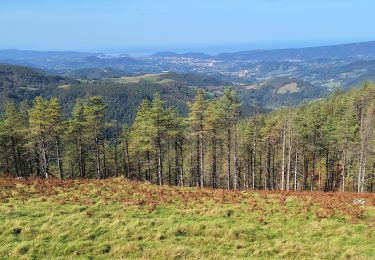
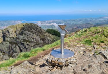
Sur les hauteurs, et par beau temps, vue sur la baie de San Sebastien et de son rocher.
Points d'intérêt
Localisation
Pays :
Espagne
Région :
Pays basque autonome
Département/Province :
Guipuscoa
Commune :
Oiartzun
Localité :
Unknown
Départ:(Dec)
Départ:(UTM)
595723 ; 4792880 (30T) N.
Commentaires
Randonnées à proximité
![Randonnée Marche Irun - cascade dEnbido- Aitzondo mines et ravin de Meazuri 2024/11/12 - Photo](https://media.geolcdn.com/t/375/260/ea942abe-41d1-4bc7-b9a0-e2b821ade3bf.jpeg&format=jpg&maxdim=2)
![Marche Marche](https://static1.geolcdn.com/sitytour/trail-icons/101.png)
cascade dEnbido- Aitzondo mines et ravin de Meazuri 2024/11/12
Marche
Difficile
Irun,
Pays basque autonome,
Guipuscoa,
Espagne
![](/images/other/stat-length.png)
11,6 km | 17,2 km-effort
3h 54min
![](https://static1.geolcdn.com/siteimages/upload/files/16400158638029165_repeat_loop_refresh_sync_direction_icon.png)
Oui
![Randonnée Marche Goizueta - Artikutza par les crêtes - Photo](https://media.geolcdn.com/t/375/260/3287c20c-9f2e-4dd1-9216-875a0e65a0ae.jpg&format=jpg&maxdim=2)
![Marche Marche](https://static1.geolcdn.com/sitytour/trail-icons/101.png)
Artikutza par les crêtes
Marche
Facile
Goizueta,
Navarre,
Inconnu,
Espagne
![](/images/other/stat-length.png)
16,7 km | 27 km-effort
4h 33min
![](https://static1.geolcdn.com/siteimages/upload/files/16400158638029165_repeat_loop_refresh_sync_direction_icon.png)
Oui
![Randonnée Marche Irun - Boucle 3 couronnes - Photo](https://media.geolcdn.com/t/375/260/41c00aa6-38bd-42a4-af79-2355a90b16df.jpg&format=jpg&maxdim=2)
![Marche Marche](https://static1.geolcdn.com/sitytour/trail-icons/101.png)
Boucle 3 couronnes
Marche
Moyen
Irun,
Pays basque autonome,
Guipuscoa,
Espagne
![](/images/other/stat-length.png)
11,3 km | 0 m-effort
4h 7min
![](https://static1.geolcdn.com/siteimages/upload/files/16400158638029165_repeat_loop_refresh_sync_direction_icon.png)
Oui
![Randonnée Marche Lesaka - Embalse de Endara 2017 05 09x_backup - Photo](https://media.geolcdn.com/t/375/260/ext.jpg?maxdim=2&url=https%3A%2F%2Fservices.sitytrail.com%2FGeolivesWS%2FDownloadMedia.ashx%3FTrailID%3D749803%26Media%3Dfix__20170125124449.jpg)
![Marche Marche](https://static1.geolcdn.com/sitytour/trail-icons/101.png)
Embalse de Endara 2017 05 09x_backup
Marche
Très facile
Lesaka,
Navarre,
Inconnu,
Espagne
![](/images/other/stat-length.png)
11,4 km | 16,3 km-effort
3h 57min
![](https://static1.geolcdn.com/siteimages/upload/files/16400158638029165_repeat_loop_refresh_sync_direction_icon.png)
Oui
![Randonnée Marche Irun - Aiako 2 Harria depuis Irun - Photo](https://media.geolcdn.com/t/375/260/ext.jpg?maxdim=2&url=https%3A%2F%2Fservices.sitytrail.com%2FGeolivesWS%2FDownloadMedia.ashx%3FTrailID%3D540485%26Media%3Dfix__20160226114401.jpg)
![Marche Marche](https://static1.geolcdn.com/sitytour/trail-icons/101.png)
Aiako 2 Harria depuis Irun
Marche
Moyen
Irun,
Pays basque autonome,
Guipuscoa,
Espagne
![](/images/other/stat-length.png)
9,4 km | 13,7 km-effort
3h 3min
![](https://static1.geolcdn.com/siteimages/upload/files/16400158638029165_repeat_loop_refresh_sync_direction_icon.png)
Non
![Randonnée Marche Lezo - Raizkibel depuis Irun avec topo - Photo](https://media.geolcdn.com/t/375/260/7d9a8293-19e8-4036-a96a-024e46e1c78c.jpg&format=jpg&maxdim=2)
![Marche Marche](https://static1.geolcdn.com/sitytour/trail-icons/101.png)
Raizkibel depuis Irun avec topo
Marche
Difficile
Lezo,
Pays basque autonome,
Guipuscoa,
Espagne
![](/images/other/stat-length.png)
16,7 km | 25 km-effort
4h 46min
![](https://static1.geolcdn.com/siteimages/upload/files/16400158638029165_repeat_loop_refresh_sync_direction_icon.png)
Non
![Randonnée Marche Oiartzun - Biandizt - Photo](https://media.geolcdn.com/t/375/260/7abd4507-3890-4b2e-a735-ffa011f8584b.jpg&format=jpg&maxdim=2)
![Marche Marche](https://static1.geolcdn.com/sitytour/trail-icons/101.png)
Biandizt
Marche
Moyen
Oiartzun,
Pays basque autonome,
Guipuscoa,
Espagne
![](/images/other/stat-length.png)
11,9 km | 19,7 km-effort
3h 44min
![](https://static1.geolcdn.com/siteimages/upload/files/16400158638029165_repeat_loop_refresh_sync_direction_icon.png)
Oui
![Randonnée Marche Irun - 3 couronnes - Photo](https://media.geolcdn.com/t/375/260/2cc10608-4714-4618-b45a-5c758f26bde5.jpg&format=jpg&maxdim=2)
![Marche Marche](https://static1.geolcdn.com/sitytour/trail-icons/101.png)
3 couronnes
Marche
Très difficile
Irun,
Pays basque autonome,
Guipuscoa,
Espagne
![](/images/other/stat-length.png)
7,6 km | 14,1 km-effort
3h 2min
![](https://static1.geolcdn.com/siteimages/upload/files/16400158638029165_repeat_loop_refresh_sync_direction_icon.png)
Oui
![Randonnée Marche Irun - Aiako Harria depuis OLA - Photo](https://media.geolcdn.com/t/375/260/ext.jpg?maxdim=2&url=https%3A%2F%2Fservices.sitytrail.com%2FGeolivesWS%2FDownloadMedia.ashx%3FTrailID%3D653663%26Media%3D20160903113427.jpg)
![Marche Marche](https://static1.geolcdn.com/sitytour/trail-icons/101.png)
Aiako Harria depuis OLA
Marche
Facile
Irun,
Pays basque autonome,
Guipuscoa,
Espagne
![](/images/other/stat-length.png)
12,3 km | 21 km-effort
6h 5min
![](https://static1.geolcdn.com/siteimages/upload/files/16400158638029165_repeat_loop_refresh_sync_direction_icon.png)
Oui