![](/images/other/stat-length.png)
![Randonnée Marche Riboux - Riboux - Forêt de Malaucène - Photo](https://media.geolcdn.com/t/1900/400/ext.pjpeg?maxdim=2&url=https%3A%2F%2Fservices.sitytrail.com%2FGeolivesWS%2FDownloadMedia.ashx%3FTrailID%3D103921%26Media%3D6772_2.jpg)
Riboux - Forêt de Malaucène
tracegps
Utilisateur
![Longueur](/images/other/stat-length.png)
Longueur
12,2 km
![Altitude max](https://static1.geolcdn.com/siteimages/upload/files/1508320355ic_sort_altitude_max_24dp.png)
Altitude max
624 m
![Dénivelé positif](https://static1.geolcdn.com/siteimages/upload/files/1508320355ic_sort_den_pos_24dp.png)
Dénivelé positif
222 m
![Km-Effort](/images/other/stat-length.png)
Km-Effort
15,2 km
![Altitude min](https://static1.geolcdn.com/siteimages/upload/files/1508320355ic_sort_altitude_min_24dp.png)
Altitude min
522 m
![Dénivelé négatif](https://static1.geolcdn.com/siteimages/upload/files/1508320355ic_sort_den_neg_24dp.png)
Dénivelé négatif
224 m
![Boucle](https://static1.geolcdn.com/siteimages/upload/files/16400158638029165_repeat_loop_refresh_sync_direction_icon.png)
Boucle
Oui
Date de création :
2014-12-10 00:00:00.0
Dernière modification :
2014-12-10 00:00:00.0
![Marche](https://static1.geolcdn.com/sitytour/trail-icons/101.png)
2h40
Difficulté : Moyen
![Scannez ce code QR pour ouvrir la randonnée dans l'application SityTrail](https://capi.geolives.com/qq0zvz2zws4bq2lad0pu/sitytour/trails/103921/qr.png?size=200)
Application GPS de randonnée GRATUITE
À propos
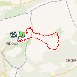
Randonnée Marche de 12,2 km à découvrir à Provence-Alpes-Côte d'Azur, Var, Riboux. Cette randonnée est proposée par tracegps.
Description
Belle randonnée peu difficile niveau 3, sur un chemin large et agréable. Retrouvez d’autres informations sur le site de Rando Loisirs à Carnoux en Provence.
Localisation
Pays :
France
Région :
Provence-Alpes-Côte d'Azur
Département/Province :
Var
Commune :
Riboux
Localité :
Unknown
Départ:(Dec)
Départ:(UTM)
724126 ; 4798364 (31T) N.
Commentaires
Randonnées à proximité
![Randonnée Marche Plan-d'Aups-Sainte-Baume - Sainte Baume 8,5 km - Photo](https://media.geolcdn.com/t/375/260/02bfd54c-87ac-472a-9dd7-603e289d99c6.jpeg&format=jpg&maxdim=2)
![Marche Marche](https://static1.geolcdn.com/sitytour/trail-icons/101.png)
Sainte Baume 8,5 km
Marche
Moyen
(1)
Plan-d'Aups-Sainte-Baume,
Provence-Alpes-Côte d'Azur,
Var,
France
![](/images/other/stat-length.png)
8,4 km | 15,5 km-effort
4h 38min
![](https://static1.geolcdn.com/siteimages/upload/files/16400158638029165_repeat_loop_refresh_sync_direction_icon.png)
Oui
![Randonnée Marche Nans-les-Pins - Le baou des glacières - Photo](https://media.geolcdn.com/t/375/260/ext.jpg?maxdim=2&url=https%3A%2F%2Fservices.sitytrail.com%2FGeolivesWS%2FDownloadMedia.ashx%3FTrailID%3D356935%26Media%3Dfix__20141025130409.jpg)
![Marche Marche](https://static1.geolcdn.com/sitytour/trail-icons/101.png)
Le baou des glacières
Marche
Moyen
(1)
Nans-les-Pins,
Provence-Alpes-Côte d'Azur,
Var,
France
![](/images/other/stat-length.png)
7,6 km | 12,2 km-effort
4h 27min
![](https://static1.geolcdn.com/siteimages/upload/files/16400158638029165_repeat_loop_refresh_sync_direction_icon.png)
Oui
![Randonnée Marche Plan-d'Aups-Sainte-Baume - Sentier merveilleux - Le paradis - La Grotte Ste Marie Madeleine - Photo](https://media.geolcdn.com/t/375/260/e69b33b5-1427-482e-bef6-59e868e7cd87.jpg&format=jpg&maxdim=2)
![Marche Marche](https://static1.geolcdn.com/sitytour/trail-icons/101.png)
Sentier merveilleux - Le paradis - La Grotte Ste Marie Madeleine
Marche
Moyen
(1)
Plan-d'Aups-Sainte-Baume,
Provence-Alpes-Côte d'Azur,
Var,
France
![](/images/other/stat-length.png)
15 km | 23 km-effort
6h 0min
![](https://static1.geolcdn.com/siteimages/upload/files/16400158638029165_repeat_loop_refresh_sync_direction_icon.png)
Oui
![Randonnée V.T.T. Signes - De Chibron à Riboux et au Grand Vallon, sur le versant sud de la Sainte Baume - Photo](https://media.geolcdn.com/t/375/260/ext.jpg?maxdim=2&url=https%3A%2F%2Fservices.sitytrail.com%2FGeolivesWS%2FDownloadMedia.ashx%3FTrailID%3D105192%26Media%3D8829_6.jpg)
![V.T.T. V.T.T.](https://static1.geolcdn.com/sitytour/trail-icons/202.png)
De Chibron à Riboux et au Grand Vallon, sur le versant sud de la Sainte Baume
V.T.T.
Moyen
(1)
Signes,
Provence-Alpes-Côte d'Azur,
Var,
France
![](/images/other/stat-length.png)
30 km | 39 km-effort
3h 0min
![](https://static1.geolcdn.com/siteimages/upload/files/16400158638029165_repeat_loop_refresh_sync_direction_icon.png)
Oui
![Randonnée Marche Cuges-les-Pins - Jean de lorette, grotte et mémorial - Photo](https://media.geolcdn.com/t/375/260/7f0fa6ce-b146-4d44-9642-97b327cde2ed.jpg&format=jpg&maxdim=2)
![Marche Marche](https://static1.geolcdn.com/sitytour/trail-icons/101.png)
Jean de lorette, grotte et mémorial
Marche
Difficile
(1)
Cuges-les-Pins,
Provence-Alpes-Côte d'Azur,
Bouches-du-Rhône,
France
![](/images/other/stat-length.png)
11,2 km | 14,6 km-effort
3h 18min
![](https://static1.geolcdn.com/siteimages/upload/files/16400158638029165_repeat_loop_refresh_sync_direction_icon.png)
Oui
![Randonnée Marche Plan-d'Aups-Sainte-Baume - Crêts de la Ste Baume - Photo](https://media.geolcdn.com/t/375/260/ext.jpg?maxdim=2&url=https%3A%2F%2Fservices.sitytrail.com%2FGeolivesWS%2FDownloadMedia.ashx%3FTrailID%3D214866%26Media%3D15409_2.jpg)
![Marche Marche](https://static1.geolcdn.com/sitytour/trail-icons/101.png)
Crêts de la Ste Baume
Marche
Moyen
(2)
Plan-d'Aups-Sainte-Baume,
Provence-Alpes-Côte d'Azur,
Var,
France
![](/images/other/stat-length.png)
15,4 km | 23 km-effort
5h 0min
![](https://static1.geolcdn.com/siteimages/upload/files/16400158638029165_repeat_loop_refresh_sync_direction_icon.png)
Oui
![Randonnée Marche Nans-les-Pins - La Croix des Glacières, Sainte-Baume - Photo](https://media.geolcdn.com/t/375/260/ext.jpg?maxdim=2&url=https%3A%2F%2Fservices.sitytrail.com%2FGeolivesWS%2FDownloadMedia.ashx%3FTrailID%3D107654%26Media%3D12647_1.jpg)
![Marche Marche](https://static1.geolcdn.com/sitytour/trail-icons/101.png)
La Croix des Glacières, Sainte-Baume
Marche
Moyen
(1)
Nans-les-Pins,
Provence-Alpes-Côte d'Azur,
Var,
France
![](/images/other/stat-length.png)
7,2 km | 12 km-effort
3h 19min
![](https://static1.geolcdn.com/siteimages/upload/files/16400158638029165_repeat_loop_refresh_sync_direction_icon.png)
Oui
![Randonnée Marche Plan-d'Aups-Sainte-Baume - Du Col du Saint-Pilon au Pas de l'Aï, Sainte Baume - Photo](https://media.geolcdn.com/t/375/260/ext.jpg?maxdim=2&url=https%3A%2F%2Fservices.sitytrail.com%2FGeolivesWS%2FDownloadMedia.ashx%3FTrailID%3D107608%26Media%3D12576_1.jpg)
![Marche Marche](https://static1.geolcdn.com/sitytour/trail-icons/101.png)
Du Col du Saint-Pilon au Pas de l'Aï, Sainte Baume
Marche
Moyen
(1)
Plan-d'Aups-Sainte-Baume,
Provence-Alpes-Côte d'Azur,
Var,
France
![](/images/other/stat-length.png)
13,1 km | 20 km-effort
5h 15min
![](https://static1.geolcdn.com/siteimages/upload/files/16400158638029165_repeat_loop_refresh_sync_direction_icon.png)
Oui
![Randonnée Marche Plan-d'Aups-Sainte-Baume - La Grotte aux oiseaux - Plan d'Aups - Photo](https://media.geolcdn.com/t/375/260/ext.jpg?maxdim=2&url=https%3A%2F%2Fservices.sitytrail.com%2FGeolivesWS%2FDownloadMedia.ashx%3FTrailID%3D103826%26Media%3D6600_1.jpg)
![Marche Marche](https://static1.geolcdn.com/sitytour/trail-icons/101.png)
La Grotte aux oiseaux - Plan d'Aups
Marche
Moyen
(1)
Plan-d'Aups-Sainte-Baume,
Provence-Alpes-Côte d'Azur,
Var,
France
![](/images/other/stat-length.png)
8,8 km | 12,5 km-effort
2h 30min
![](https://static1.geolcdn.com/siteimages/upload/files/16400158638029165_repeat_loop_refresh_sync_direction_icon.png)
Oui
circuit sympa mais à ne pas faire sans GPS . Aucun repère ou balisage . Par moments la trace passe par des sentiers pas entretenus surtout au debut