![](/images/other/stat-length.png)
![Randonnée V.T.T. La Ferté-Saint-Aubin - La Ferté St Anbin - Vouzon - Photo](https://media.geolcdn.com/t/1900/400/ext.pjpeg?maxdim=2&url=https%3A%2F%2Fservices.sitytrail.com%2FGeolivesWS%2FDownloadMedia.ashx%3FTrailID%3D103899%26Media%3D6725_3.jpg)
La Ferté St Anbin - Vouzon
tracegps
Utilisateur
![Longueur](/images/other/stat-length.png)
Longueur
37 km
![Altitude max](https://static1.geolcdn.com/siteimages/upload/files/1508320355ic_sort_altitude_max_24dp.png)
Altitude max
155 m
![Dénivelé positif](https://static1.geolcdn.com/siteimages/upload/files/1508320355ic_sort_den_pos_24dp.png)
Dénivelé positif
298 m
![Km-Effort](/images/other/stat-length.png)
Km-Effort
40 km
![Altitude min](https://static1.geolcdn.com/siteimages/upload/files/1508320355ic_sort_altitude_min_24dp.png)
Altitude min
100 m
![Dénivelé négatif](https://static1.geolcdn.com/siteimages/upload/files/1508320355ic_sort_den_neg_24dp.png)
Dénivelé négatif
293 m
![Boucle](https://static1.geolcdn.com/siteimages/upload/files/16400158638029165_repeat_loop_refresh_sync_direction_icon.png)
Boucle
Oui
Date de création :
2014-12-10 00:00:00.0
Dernière modification :
2014-12-10 00:00:00.0
![V.T.T.](https://static1.geolcdn.com/sitytour/trail-icons/202.png)
3h00
Difficulté : Moyen
![Scannez ce code QR pour ouvrir la randonnée dans l'application SityTrail](https://capi.geolives.com/qq0zvz2zws4bq2lad0pu/sitytour/trails/103899/qr.png?size=200)
Application GPS de randonnée GRATUITE
À propos
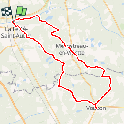
Randonnée V.T.T. de 37 km à découvrir à Centre-Val de Loire, Loiret, La Ferté-Saint-Aubin. Cette randonnée est proposée par tracegps.
Description
Départ du parking du château de la Ferté Saint Aubin vers Vouzon par les GR de Sologne et retour par Ménestreau en Villette et la rive du Cosson.
Localisation
Pays :
France
Région :
Centre-Val de Loire
Département/Province :
Loiret
Commune :
La Ferté-Saint-Aubin
Localité :
Unknown
Départ:(Dec)
Départ:(UTM)
420685 ; 5286415 (31T) N.
Commentaires
Randonnées à proximité
![Randonnée V.T.T. La Ferté-Saint-Aubin - La ferté - Yvoy le marron - Photo](https://media.geolcdn.com/t/375/260/ext.jpg?maxdim=2&url=https%3A%2F%2Fservices.sitytrail.com%2FGeolivesWS%2FDownloadMedia.ashx%3FTrailID%3D722694%26Media%3D20170329165819.jpg)
![V.T.T. V.T.T.](https://static1.geolcdn.com/sitytour/trail-icons/202.png)
La ferté - Yvoy le marron
V.T.T.
Facile
La Ferté-Saint-Aubin,
Centre-Val de Loire,
Loiret,
France
![](/images/other/stat-length.png)
23 km | 26 km-effort
2h 23min
![](https://static1.geolcdn.com/siteimages/upload/files/16400158638029165_repeat_loop_refresh_sync_direction_icon.png)
Oui
![Randonnée Marche La Ferté-Saint-Aubin - LA FERTE ST AUBIN - Photo](https://media.geolcdn.com/t/375/260/ext.jpg?maxdim=2&url=https%3A%2F%2Fstatic1.geolcdn.com%2Fsiteimages%2Fupload%2Ffiles%2F1553511878bg_sport_marche.png)
![Marche Marche](https://static1.geolcdn.com/sitytour/trail-icons/101.png)
LA FERTE ST AUBIN
Marche
Très facile
La Ferté-Saint-Aubin,
Centre-Val de Loire,
Loiret,
France
![](/images/other/stat-length.png)
7,5 km | 8,3 km-effort
1h 50min
![](https://static1.geolcdn.com/siteimages/upload/files/16400158638029165_repeat_loop_refresh_sync_direction_icon.png)
Oui
![Randonnée V.T.C. La Ferté-Saint-Aubin - De la Ferté St aubin à Mézières lez Cléry - Photo](https://media.geolcdn.com/t/375/260/ext.jpg?maxdim=2&url=https%3A%2F%2Fstatic1.geolcdn.com%2Fsiteimages%2Fupload%2Ffiles%2F1524743154velo.jpg)
![V.T.C. V.T.C.](https://static1.geolcdn.com/sitytour/trail-icons/203.png)
De la Ferté St aubin à Mézières lez Cléry
V.T.C.
Facile
La Ferté-Saint-Aubin,
Centre-Val de Loire,
Loiret,
France
![](/images/other/stat-length.png)
19,1 km | 21 km-effort
2h 3min
![](https://static1.geolcdn.com/siteimages/upload/files/16400158638029165_repeat_loop_refresh_sync_direction_icon.png)
Non
![Randonnée V.T.T. La Ferté-Saint-Aubin - VTT 36km La Ferté Chaumont Yvoy - Photo](https://media.geolcdn.com/t/375/260/ext.jpg?maxdim=2&url=https%3A%2F%2Fstatic1.geolcdn.com%2Fsiteimages%2Fupload%2Ffiles%2F1524743154velo.jpg)
![V.T.T. V.T.T.](https://static1.geolcdn.com/sitytour/trail-icons/202.png)
VTT 36km La Ferté Chaumont Yvoy
V.T.T.
Très facile
La Ferté-Saint-Aubin,
Centre-Val de Loire,
Loiret,
France
![](/images/other/stat-length.png)
36 km | 40 km-effort
2h 49min
![](https://static1.geolcdn.com/siteimages/upload/files/16400158638029165_repeat_loop_refresh_sync_direction_icon.png)
Oui
![Randonnée Marche La Ferté-Saint-Aubin - La Ferté-Saint -Aubin PR du Mazuray - Photo](https://media.geolcdn.com/t/375/260/ext.jpg?maxdim=2&url=https%3A%2F%2Fstatic1.geolcdn.com%2Fsiteimages%2Fupload%2Ffiles%2F1553511878bg_sport_marche.png)
![Marche Marche](https://static1.geolcdn.com/sitytour/trail-icons/101.png)
La Ferté-Saint -Aubin PR du Mazuray
Marche
Facile
La Ferté-Saint-Aubin,
Centre-Val de Loire,
Loiret,
France
![](/images/other/stat-length.png)
12,5 km | 13,9 km-effort
3h 3min
![](https://static1.geolcdn.com/siteimages/upload/files/16400158638029165_repeat_loop_refresh_sync_direction_icon.png)
Oui
![Randonnée V.T.T. La Ferté-Saint-Aubin - 2010-09-19 LFSA - Lamothe Beuvron - Photo](https://media.geolcdn.com/t/375/260/ext.jpg?maxdim=2&url=https%3A%2F%2Fstatic1.geolcdn.com%2Fsiteimages%2Fupload%2Ffiles%2F1524743154velo.jpg)
![V.T.T. V.T.T.](https://static1.geolcdn.com/sitytour/trail-icons/202.png)
2010-09-19 LFSA - Lamothe Beuvron
V.T.T.
Très facile
La Ferté-Saint-Aubin,
Centre-Val de Loire,
Loiret,
France
![](/images/other/stat-length.png)
51 km | 57 km-effort
Inconnu
![](https://static1.geolcdn.com/siteimages/upload/files/16400158638029165_repeat_loop_refresh_sync_direction_icon.png)
Oui
![Randonnée Marche La Ferté-Saint-Aubin - la fierté menestreau - Photo](https://media.geolcdn.com/t/375/260/ext.jpg?maxdim=2&url=https%3A%2F%2Fstatic1.geolcdn.com%2Fsiteimages%2Fupload%2Ffiles%2F1553511878bg_sport_marche.png)
![Marche Marche](https://static1.geolcdn.com/sitytour/trail-icons/101.png)
la fierté menestreau
Marche
Difficile
La Ferté-Saint-Aubin,
Centre-Val de Loire,
Loiret,
France
![](/images/other/stat-length.png)
12,5 km | 13,8 km-effort
2h 29min
![](https://static1.geolcdn.com/siteimages/upload/files/16400158638029165_repeat_loop_refresh_sync_direction_icon.png)
Oui
![Randonnée Marche La Ferté-Saint-Aubin - la lumière route des traues - Photo](https://media.geolcdn.com/t/375/260/ext.jpg?maxdim=2&url=https%3A%2F%2Fstatic1.geolcdn.com%2Fsiteimages%2Fupload%2Ffiles%2F1553511878bg_sport_marche.png)
![Marche Marche](https://static1.geolcdn.com/sitytour/trail-icons/101.png)
la lumière route des traues
Marche
Très facile
La Ferté-Saint-Aubin,
Centre-Val de Loire,
Loiret,
France
![](/images/other/stat-length.png)
10,5 km | 11,9 km-effort
2h 12min
![](https://static1.geolcdn.com/siteimages/upload/files/16400158638029165_repeat_loop_refresh_sync_direction_icon.png)
Oui
![Randonnée Marche La Ferté-Saint-Aubin - les trays - Photo](https://media.geolcdn.com/t/375/260/ext.jpg?maxdim=2&url=https%3A%2F%2Fstatic1.geolcdn.com%2Fsiteimages%2Fupload%2Ffiles%2F1553511878bg_sport_marche.png)
![Marche Marche](https://static1.geolcdn.com/sitytour/trail-icons/101.png)
les trays
Marche
Facile
La Ferté-Saint-Aubin,
Centre-Val de Loire,
Loiret,
France
![](/images/other/stat-length.png)
11,6 km | 12,6 km-effort
2h 7min
![](https://static1.geolcdn.com/siteimages/upload/files/16400158638029165_repeat_loop_refresh_sync_direction_icon.png)
Oui