![](/images/other/stat-length.png)
![Randonnée V.T.T. Ottrott - Boucle de Otrott au Mont St Odile - Photo](https://media.geolcdn.com/t/1900/400/ext.pjpeg?maxdim=2&url=https%3A%2F%2Fservices.sitytrail.com%2FGeolivesWS%2FDownloadMedia.ashx%3FTrailID%3D103773%26Media%3D6538_2.jpg)
Boucle de Otrott au Mont St Odile
tracegps
Utilisateur
![Longueur](/images/other/stat-length.png)
Longueur
30 km
![Altitude max](https://static1.geolcdn.com/siteimages/upload/files/1508320355ic_sort_altitude_max_24dp.png)
Altitude max
789 m
![Dénivelé positif](https://static1.geolcdn.com/siteimages/upload/files/1508320355ic_sort_den_pos_24dp.png)
Dénivelé positif
1154 m
![Km-Effort](/images/other/stat-length.png)
Km-Effort
45 km
![Altitude min](https://static1.geolcdn.com/siteimages/upload/files/1508320355ic_sort_altitude_min_24dp.png)
Altitude min
311 m
![Dénivelé négatif](https://static1.geolcdn.com/siteimages/upload/files/1508320355ic_sort_den_neg_24dp.png)
Dénivelé négatif
1154 m
![Boucle](https://static1.geolcdn.com/siteimages/upload/files/16400158638029165_repeat_loop_refresh_sync_direction_icon.png)
Boucle
Oui
Date de création :
2014-12-10 00:00:00.0
Dernière modification :
2014-12-10 00:00:00.0
![V.T.T.](https://static1.geolcdn.com/sitytour/trail-icons/202.png)
3h45
Difficulté : Difficile
![Scannez ce code QR pour ouvrir la randonnée dans l'application SityTrail](https://capi.geolives.com/qq0zvz2zws4bq2lad0pu/sitytour/trails/103773/qr.png?size=200)
Application GPS de randonnée GRATUITE
À propos
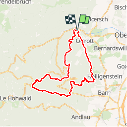
Randonnée V.T.T. de 30 km à découvrir à Grand Est, Bas-Rhin, Ottrott. Cette randonnée est proposée par tracegps.
Description
Le circuit n'est pas très long mais très varié tant par les dénivelés que par la technique. De nombreuses vues dont il n'est pas possible de décrire autrement qu'en s'y rendant par soi même. En un mot, c'est un parcours magnifique !!
Localisation
Pays :
France
Région :
Grand Est
Département/Province :
Bas-Rhin
Commune :
Ottrott
Localité :
Unknown
Départ:(Dec)
Départ:(UTM)
382677 ; 5369335 (32U) N.
Commentaires
Randonnées à proximité
![Randonnée Marche Ottrott - Le circuit sud du Mur Païen - Photo](https://media.geolcdn.com/t/375/260/ext.jpg?maxdim=2&url=https%3A%2F%2Fservices.sitytrail.com%2FGeolivesWS%2FDownloadMedia.ashx%3FTrailID%3D771291%26Media%3Dfix__20170611121416.jpg)
![Marche Marche](https://static1.geolcdn.com/sitytour/trail-icons/101.png)
Le circuit sud du Mur Païen
Marche
Facile
(2)
Ottrott,
Grand Est,
Bas-Rhin,
France
![](/images/other/stat-length.png)
4,9 km | 6,3 km-effort
1h 56min
![](https://static1.geolcdn.com/siteimages/upload/files/16400158638029165_repeat_loop_refresh_sync_direction_icon.png)
Non
![Randonnée Marche Ottrott - Le circuit nord du Mur Païen - Photo](https://media.geolcdn.com/t/375/260/ext.jpg?maxdim=2&url=https%3A%2F%2Fservices.sitytrail.com%2FGeolivesWS%2FDownloadMedia.ashx%3FTrailID%3D771290%26Media%3Dfix__20170611105927.jpg)
![Marche Marche](https://static1.geolcdn.com/sitytour/trail-icons/101.png)
Le circuit nord du Mur Païen
Marche
Facile
(1)
Ottrott,
Grand Est,
Bas-Rhin,
France
![](/images/other/stat-length.png)
5,9 km | 8,5 km-effort
2h 4min
![](https://static1.geolcdn.com/siteimages/upload/files/16400158638029165_repeat_loop_refresh_sync_direction_icon.png)
Non
![Randonnée Marche Ottrott - Le Mont Sainte-Odile depuis Otrott - Photo](https://media.geolcdn.com/t/375/260/ext.jpg?maxdim=2&url=https%3A%2F%2Fservices.sitytrail.com%2FGeolivesWS%2FDownloadMedia.ashx%3FTrailID%3D506359%26Media%3Dfix__20151226143401.jpg)
![Marche Marche](https://static1.geolcdn.com/sitytour/trail-icons/101.png)
Le Mont Sainte-Odile depuis Otrott
Marche
Moyen
(1)
Ottrott,
Grand Est,
Bas-Rhin,
France
![](/images/other/stat-length.png)
13 km | 20 km-effort
6h 18min
![](https://static1.geolcdn.com/siteimages/upload/files/16400158638029165_repeat_loop_refresh_sync_direction_icon.png)
Oui
![Randonnée Marche Ottrott - Montée vers le Mont Sainte-Odile - Photo](https://media.geolcdn.com/t/375/260/ext.jpg?maxdim=2&url=https%3A%2F%2Fservices.sitytrail.com%2FGeolivesWS%2FDownloadMedia.ashx%3FTrailID%3D453779%26Media%3Dfix__20150802160011.jpg)
![Marche Marche](https://static1.geolcdn.com/sitytour/trail-icons/101.png)
Montée vers le Mont Sainte-Odile
Marche
Difficile
(1)
Ottrott,
Grand Est,
Bas-Rhin,
France
![](/images/other/stat-length.png)
17,6 km | 26 km-effort
5h 52min
![](https://static1.geolcdn.com/siteimages/upload/files/16400158638029165_repeat_loop_refresh_sync_direction_icon.png)
Oui
![Randonnée Marche Ottrott - Le mur païen - Photo](https://media.geolcdn.com/t/375/260/ext.jpg?maxdim=2&url=https%3A%2F%2Fservices.sitytrail.com%2FGeolivesWS%2FDownloadMedia.ashx%3FTrailID%3D355557%26Media%3Dfix__20141019162126.jpg)
![Marche Marche](https://static1.geolcdn.com/sitytour/trail-icons/101.png)
Le mur païen
Marche
Moyen
(4)
Ottrott,
Grand Est,
Bas-Rhin,
France
![](/images/other/stat-length.png)
10,5 km | 14,5 km-effort
4h 36min
![](https://static1.geolcdn.com/siteimages/upload/files/16400158638029165_repeat_loop_refresh_sync_direction_icon.png)
Oui
![Randonnée Marche Ottrott - Mur Paien complet - Photo](https://media.geolcdn.com/t/375/260/ext.jpg?maxdim=2&url=https%3A%2F%2Fservices.sitytrail.com%2FGeolivesWS%2FDownloadMedia.ashx%3FTrailID%3D257852%26Media%3Dfix__20140316152516.jpg)
![Marche Marche](https://static1.geolcdn.com/sitytour/trail-icons/101.png)
Mur Paien complet
Marche
Moyen
(1)
Ottrott,
Grand Est,
Bas-Rhin,
France
![](/images/other/stat-length.png)
12 km | 16,4 km-effort
5h 25min
![](https://static1.geolcdn.com/siteimages/upload/files/16400158638029165_repeat_loop_refresh_sync_direction_icon.png)
Oui
![Randonnée V.T.T. Barr - Circuit des 3 Petits Ponts - Photo](https://media.geolcdn.com/t/375/260/ext.jpg?maxdim=2&url=https%3A%2F%2Fservices.sitytrail.com%2FGeolivesWS%2FDownloadMedia.ashx%3FTrailID%3D101124%26Media%3D611_1.jpg)
![V.T.T. V.T.T.](https://static1.geolcdn.com/sitytour/trail-icons/202.png)
Circuit des 3 Petits Ponts
V.T.T.
Difficile
(1)
Barr,
Grand Est,
Bas-Rhin,
France
![](/images/other/stat-length.png)
15,9 km | 22 km-effort
1h 19min
![](https://static1.geolcdn.com/siteimages/upload/files/16400158638029165_repeat_loop_refresh_sync_direction_icon.png)
Oui
![Randonnée V.T.T. Ottrott - Sainte-Odile East-Face - Photo](https://media.geolcdn.com/t/375/260/ext.jpg?maxdim=2&url=https%3A%2F%2Fservices.sitytrail.com%2FGeolivesWS%2FDownloadMedia.ashx%3FTrailID%3D100800%26Media%3D307_1.jpg)
![V.T.T. V.T.T.](https://static1.geolcdn.com/sitytour/trail-icons/202.png)
Sainte-Odile East-Face
V.T.T.
Difficile
(1)
Ottrott,
Grand Est,
Bas-Rhin,
France
![](/images/other/stat-length.png)
24 km | 39 km-effort
3h 0min
![](https://static1.geolcdn.com/siteimages/upload/files/16400158638029165_repeat_loop_refresh_sync_direction_icon.png)
Oui
![Randonnée Randonnée équestre Mollkirch - 2024-04-28 Picnic CVA Maennelstein - Photo](https://media.geolcdn.com/t/375/260/492e641b-5f59-4751-a81d-a41633bc94a3.jpg&format=jpg&maxdim=2)
![Randonnée équestre Randonnée équestre](https://static1.geolcdn.com/sitytour/trail-icons/301.png)
2024-04-28 Picnic CVA Maennelstein
Randonnée équestre
Difficile
Mollkirch,
Grand Est,
Bas-Rhin,
France
![](/images/other/stat-length.png)
34 km | 48 km-effort
6h 20min
![](https://static1.geolcdn.com/siteimages/upload/files/16400158638029165_repeat_loop_refresh_sync_direction_icon.png)
Oui