![](/images/other/stat-length.png)
![Randonnée Marche Eaux-Bonnes - Traversée dans les Pyrénées de Gourette à Luz Saint Sauveur - Photo](https://media.geolcdn.com/t/1900/400/ext.pjpeg?maxdim=2&url=https%3A%2F%2Fservices.sitytrail.com%2FGeolivesWS%2FDownloadMedia.ashx%3FTrailID%3D103771%26Media%3D6531_2.jpg)
Traversée dans les Pyrénées de Gourette à Luz Saint Sauveur
tracegps
Utilisateur
![Longueur](/images/other/stat-length.png)
![Altitude max](https://static1.geolcdn.com/siteimages/upload/files/1508320355ic_sort_altitude_max_24dp.png)
![Dénivelé positif](https://static1.geolcdn.com/siteimages/upload/files/1508320355ic_sort_den_pos_24dp.png)
![Km-Effort](/images/other/stat-length.png)
![Altitude min](https://static1.geolcdn.com/siteimages/upload/files/1508320355ic_sort_altitude_min_24dp.png)
![Dénivelé négatif](https://static1.geolcdn.com/siteimages/upload/files/1508320355ic_sort_den_neg_24dp.png)
![Boucle](https://static1.geolcdn.com/siteimages/upload/files/16400158638029165_repeat_loop_refresh_sync_direction_icon.png)
![Marche](https://static1.geolcdn.com/sitytour/trail-icons/101.png)
54h00
Difficulté : Très difficile
![Scannez ce code QR pour ouvrir la randonnée dans l'application SityTrail](https://capi.geolives.com/qq0zvz2zws4bq2lad0pu/sitytour/trails/103771/qr.png?size=200)
Application GPS de randonnée GRATUITE
À propos
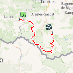
Randonnée Marche de 95 km à découvrir à Nouvelle-Aquitaine, Pyrénées-Atlantiques, Eaux-Bonnes. Cette randonnée est proposée par tracegps.
Description
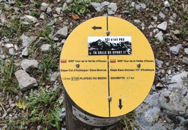
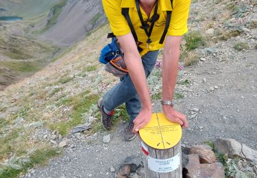
Magnifique Traversée dans les Pyrénées de Gourette à Luz Saint Sauveur Jour 1 : de Luz Saint Sauveur à Arrens Marsous Jour 2 : de Arrens Marsous au Lac du Barbat / Bivouac Jour 3 : du Lac du Barbat au Refuge Wallon / Bivouac Jour 4 : du Refuge Wallon au Refuge des Oulettes de Gaube/ Bivouac Jour 5 : du Refuge des Oulettes à Gavarnie / Camping Jour 6 : de Gavarnie à Luz St Sauveur.
Localisation
Commentaires
Randonnées à proximité
![Randonnée A pied Arbéost - ARBEOST le tour des quartiers d'Arbeost G3 fait TC - Photo](https://media.geolcdn.com/t/375/260/ext.jpg?maxdim=2&url=https%3A%2F%2Fstatic1.geolcdn.com%2Fsiteimages%2Fupload%2Ffiles%2F1545311037marcheuse_200dpi.jpg)
![A pied A pied](https://static1.geolcdn.com/sitytour/trail-icons/100.png)
A pied
![](/images/other/stat-length.png)
![](https://static1.geolcdn.com/siteimages/upload/files/16400158638029165_repeat_loop_refresh_sync_direction_icon.png)
![Randonnée Marche Eaux-Bonnes - Le Pic Sanctus 2482m depuis Gourette - Photo](https://media.geolcdn.com/t/375/260/ext.jpg?maxdim=2&url=https%3A%2F%2Fservices.sitytrail.com%2FGeolivesWS%2FDownloadMedia.ashx%3FTrailID%3D103539%26Media%3D5754_1.jpg)
![Marche Marche](https://static1.geolcdn.com/sitytour/trail-icons/101.png)
Marche
![](/images/other/stat-length.png)
![](https://static1.geolcdn.com/siteimages/upload/files/16400158638029165_repeat_loop_refresh_sync_direction_icon.png)
![Randonnée Course à pied Eaux-Bonnes - GOURETTE la cabane de Bouy](https://media.geolcdn.com/t/375/260/ef1c0c9e-1794-4cec-b3c6-ee6194b0829e.jpg&format=jpg&maxdim=2)
![Course à pied Course à pied](https://static1.geolcdn.com/sitytour/trail-icons/103.png)
Course à pied
![](/images/other/stat-length.png)
![](https://static1.geolcdn.com/siteimages/upload/files/16400158638029165_repeat_loop_refresh_sync_direction_icon.png)
![Randonnée sport Eaux-Bonnes - 2023-07-17_22h07m36_Balisage - Gourette Cabane de cezy - Photo](https://media.geolcdn.com/t/375/260/ext.jpg?maxdim=2&url=https%3A%2F%2Fsecurestorage.geolives.com%2Fsitytour%2Ftrail-bg%2Fdefault.jpg)
sport
![](/images/other/stat-length.png)
![](https://static1.geolcdn.com/siteimages/upload/files/16400158638029165_repeat_loop_refresh_sync_direction_icon.png)
![Randonnée A pied Béost - Les crêtes d’Andreyt - Photo](https://media.geolcdn.com/t/375/260/6e4e7f92-4044-4711-ad6d-19596eb81d86.jpeg&format=jpg&maxdim=2)
![A pied A pied](https://static1.geolcdn.com/sitytour/trail-icons/100.png)
A pied
![](/images/other/stat-length.png)
![](https://static1.geolcdn.com/siteimages/upload/files/16400158638029165_repeat_loop_refresh_sync_direction_icon.png)
![Randonnée A pied Eaux-Bonnes - Le Lac d'Anglas - Photo](https://media.geolcdn.com/t/375/260/62e92f74-58d3-475a-994a-f5302851e450.jpeg&format=jpg&maxdim=2)
![A pied A pied](https://static1.geolcdn.com/sitytour/trail-icons/100.png)
A pied
![](/images/other/stat-length.png)
![](https://static1.geolcdn.com/siteimages/upload/files/16400158638029165_repeat_loop_refresh_sync_direction_icon.png)
![Randonnée Marche Béost - soum de Grum fait - Photo](https://media.geolcdn.com/t/375/260/ext.jpg?maxdim=2&url=https%3A%2F%2Fstatic1.geolcdn.com%2Fsiteimages%2Fupload%2Ffiles%2F1553511878bg_sport_marche.png)
![Marche Marche](https://static1.geolcdn.com/sitytour/trail-icons/101.png)
Marche
![](/images/other/stat-length.png)
![](https://static1.geolcdn.com/siteimages/upload/files/16400158638029165_repeat_loop_refresh_sync_direction_icon.png)
![Randonnée Marche Eaux-Bonnes - GOURETTE BALISAGE - Photo](https://media.geolcdn.com/t/375/260/91b4972f-7fc3-4665-a87b-7ceedcb2de1c.jpg&format=jpg&maxdim=2)
![Marche Marche](https://static1.geolcdn.com/sitytour/trail-icons/101.png)
Marche
![](/images/other/stat-length.png)
![](https://static1.geolcdn.com/siteimages/upload/files/16400158638029165_repeat_loop_refresh_sync_direction_icon.png)
![Randonnée Marche Eaux-Bonnes - balisage GR10U 2023 - Photo](https://media.geolcdn.com/t/375/260/213ad87a-8380-4fb1-b585-b20ca185a4f6.jpg&format=jpg&maxdim=2)
![Marche Marche](https://static1.geolcdn.com/sitytour/trail-icons/101.png)
Marche
![](/images/other/stat-length.png)
![](https://static1.geolcdn.com/siteimages/upload/files/16400158638029165_repeat_loop_refresh_sync_direction_icon.png)