![](/images/other/stat-length.png)
![Randonnée V.T.T. Sillé-le-Guillaume - Autour du lac de Sillé le Guillaume - Photo](https://media.geolcdn.com/t/1900/400/ext.pjpeg?maxdim=2&url=https%3A%2F%2Fservices.sitytrail.com%2FGeolivesWS%2FDownloadMedia.ashx%3FTrailID%3D103734%26Media%3D6401_1.jpg)
Autour du lac de Sillé le Guillaume
tracegps
Utilisateur
![Longueur](/images/other/stat-length.png)
Longueur
33 km
![Altitude max](https://static1.geolcdn.com/siteimages/upload/files/1508320355ic_sort_altitude_max_24dp.png)
Altitude max
284 m
![Dénivelé positif](https://static1.geolcdn.com/siteimages/upload/files/1508320355ic_sort_den_pos_24dp.png)
Dénivelé positif
542 m
![Km-Effort](/images/other/stat-length.png)
Km-Effort
41 km
![Altitude min](https://static1.geolcdn.com/siteimages/upload/files/1508320355ic_sort_altitude_min_24dp.png)
Altitude min
153 m
![Dénivelé négatif](https://static1.geolcdn.com/siteimages/upload/files/1508320355ic_sort_den_neg_24dp.png)
Dénivelé négatif
542 m
![Boucle](https://static1.geolcdn.com/siteimages/upload/files/16400158638029165_repeat_loop_refresh_sync_direction_icon.png)
Boucle
Oui
Date de création :
2014-12-10 00:00:00.0
Dernière modification :
2014-12-10 00:00:00.0
![V.T.T.](https://static1.geolcdn.com/sitytour/trail-icons/202.png)
3h00
Difficulté : Difficile
![Scannez ce code QR pour ouvrir la randonnée dans l'application SityTrail](https://capi.geolives.com/qq0zvz2zws4bq2lad0pu/sitytour/trails/103734/qr.png?size=200)
Application GPS de randonnée GRATUITE
À propos
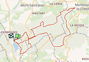
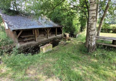
Randonnée V.T.T. de 33 km à découvrir à Pays de la Loire, Sarthe, Sillé-le-Guillaume. Cette randonnée est proposée par tracegps.
Description
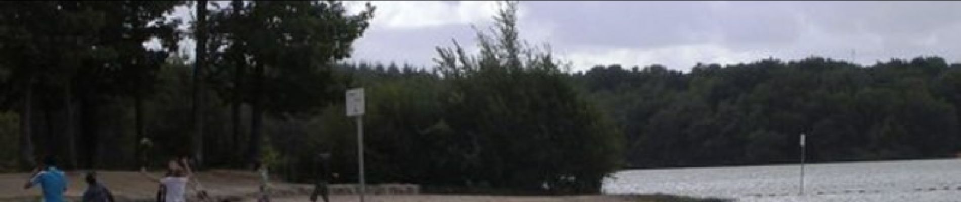
Encore un très joli parcours balisé avec des passages en montée assez difficile ( mais rares) et des descentes ou le casque semble vraiment indispensable. Cadre magnifique, passage dans torrent à proximité de Montreuil. Forêt de pins de de conifères.
Localisation
Pays :
France
Région :
Pays de la Loire
Département/Province :
Sarthe
Commune :
Sillé-le-Guillaume
Localité :
Unknown
Départ:(Dec)
Départ:(UTM)
713120 ; 5343946 (30U) N.
Commentaires
Randonnées à proximité
![Randonnée A pied Sillé-le-Guillaume - Tour du Grand Étang - Photo](https://media.geolcdn.com/t/375/260/7678a41d-26a8-4774-b077-be8b72792415.jpeg&format=jpg&maxdim=2)
![A pied A pied](https://static1.geolcdn.com/sitytour/trail-icons/100.png)
Tour du Grand Étang
A pied
Facile
Sillé-le-Guillaume,
Pays de la Loire,
Sarthe,
France
![](/images/other/stat-length.png)
3,8 km | 4,4 km-effort
1h 0min
![](https://static1.geolcdn.com/siteimages/upload/files/16400158638029165_repeat_loop_refresh_sync_direction_icon.png)
Oui
![Randonnée Marche Sillé-le-Guillaume - adal_stesuzanne 20160530 m - Photo](https://media.geolcdn.com/t/375/260/ext.jpg?maxdim=2&url=https%3A%2F%2Fstatic1.geolcdn.com%2Fsiteimages%2Fupload%2Ffiles%2F1553511878bg_sport_marche.png)
![Marche Marche](https://static1.geolcdn.com/sitytour/trail-icons/101.png)
adal_stesuzanne 20160530 m
Marche
Moyen
(1)
Sillé-le-Guillaume,
Pays de la Loire,
Sarthe,
France
![](/images/other/stat-length.png)
14,1 km | 17,1 km-effort
3h 42min
![](https://static1.geolcdn.com/siteimages/upload/files/16400158638029165_repeat_loop_refresh_sync_direction_icon.png)
Oui
![Randonnée Marche Sillé-le-Guillaume - 2 = Sillé le Guillaume - Fresnay sur Sarthe - Photo](https://media.geolcdn.com/t/375/260/4442b319-6958-42fe-a48c-ac594aca7731.jpg&format=jpg&maxdim=2)
![Marche Marche](https://static1.geolcdn.com/sitytour/trail-icons/101.png)
2 = Sillé le Guillaume - Fresnay sur Sarthe
Marche
Facile
Sillé-le-Guillaume,
Pays de la Loire,
Sarthe,
France
![](/images/other/stat-length.png)
28 km | 34 km-effort
5h 50min
![](https://static1.geolcdn.com/siteimages/upload/files/16400158638029165_repeat_loop_refresh_sync_direction_icon.png)
Non
![Randonnée Marche Mont-Saint-Jean - 1= Mont St Jean ~ Sillé le Guillaume - Photo](https://media.geolcdn.com/t/375/260/9d9d2a18-9e4c-4e8c-8ec5-aba24ab36bf2.jpg&format=jpg&maxdim=2)
![Marche Marche](https://static1.geolcdn.com/sitytour/trail-icons/101.png)
1= Mont St Jean ~ Sillé le Guillaume
Marche
Très facile
Mont-Saint-Jean,
Pays de la Loire,
Sarthe,
France
![](/images/other/stat-length.png)
9,1 km | 11,7 km-effort
1h 52min
![](https://static1.geolcdn.com/siteimages/upload/files/16400158638029165_repeat_loop_refresh_sync_direction_icon.png)
Non
![Randonnée A pied Saint-Germain-de-Coulamer - Sentier de Bel Air (b) - Photo](https://media.geolcdn.com/t/375/260/ext.jpg?maxdim=2&url=https%3A%2F%2Fstatic1.geolcdn.com%2Fsiteimages%2Fupload%2Ffiles%2F1545311037marcheuse_200dpi.jpg)
![A pied A pied](https://static1.geolcdn.com/sitytour/trail-icons/100.png)
Sentier de Bel Air (b)
A pied
Facile
Saint-Germain-de-Coulamer,
Pays de la Loire,
Mayenne,
France
![](/images/other/stat-length.png)
4,9 km | 6,3 km-effort
1h 25min
![](https://static1.geolcdn.com/siteimages/upload/files/16400158638029165_repeat_loop_refresh_sync_direction_icon.png)
Oui
![Randonnée V.T.T. Sillé-le-Guillaume - Autour de Sillé le Guillaume - Photo](https://media.geolcdn.com/t/375/260/ext.jpg?maxdim=2&url=https%3A%2F%2Fservices.sitytrail.com%2FGeolivesWS%2FDownloadMedia.ashx%3FTrailID%3D103733%26Media%3D6399_1.jpg)
![V.T.T. V.T.T.](https://static1.geolcdn.com/sitytour/trail-icons/202.png)
Autour de Sillé le Guillaume
V.T.T.
Difficile
Sillé-le-Guillaume,
Pays de la Loire,
Sarthe,
France
![](/images/other/stat-length.png)
43 km | 51 km-effort
4h 0min
![](https://static1.geolcdn.com/siteimages/upload/files/16400158638029165_repeat_loop_refresh_sync_direction_icon.png)
Oui
![Randonnée Marche Mont-Saint-Jean - Tour des Alpes Mancelles en 4 jours - Photo](https://media.geolcdn.com/t/375/260/ext.jpg?maxdim=2&url=https%3A%2F%2Fstatic1.geolcdn.com%2Fsiteimages%2Fupload%2Ffiles%2F1553511878bg_sport_marche.png)
![Marche Marche](https://static1.geolcdn.com/sitytour/trail-icons/101.png)
Tour des Alpes Mancelles en 4 jours
Marche
Facile
Mont-Saint-Jean,
Pays de la Loire,
Sarthe,
France
![](/images/other/stat-length.png)
87 km | 108 km-effort
17h 0min
![](https://static1.geolcdn.com/siteimages/upload/files/16400158638029165_repeat_loop_refresh_sync_direction_icon.png)
Oui
![Randonnée Marche nordique Sillé-le-Guillaume - Fr Coco plage. RS 16-01-2023 8,8 km - Photo](https://media.geolcdn.com/t/375/260/ext.jpg?maxdim=2&url=https%3A%2F%2Fstatic1.geolcdn.com%2Fsiteimages%2Fupload%2Ffiles%2F1545311037marcheuse_200dpi.jpg)
![Marche nordique Marche nordique](https://static1.geolcdn.com/sitytour/trail-icons/102.png)
Fr Coco plage. RS 16-01-2023 8,8 km
Marche nordique
Très facile
Sillé-le-Guillaume,
Pays de la Loire,
Sarthe,
France
![](/images/other/stat-length.png)
8,8 km | 10,4 km-effort
2h 1min
![](https://static1.geolcdn.com/siteimages/upload/files/16400158638029165_repeat_loop_refresh_sync_direction_icon.png)
Oui
![Randonnée V.T.T. Sillé-le-Guillaume - tour en forêt de Sillé. - Photo](https://media.geolcdn.com/t/375/260/ext.jpg?maxdim=2&url=https%3A%2F%2Fstatic1.geolcdn.com%2Fsiteimages%2Fupload%2Ffiles%2F1524743154velo.jpg)
![V.T.T. V.T.T.](https://static1.geolcdn.com/sitytour/trail-icons/202.png)
tour en forêt de Sillé.
V.T.T.
Moyen
Sillé-le-Guillaume,
Pays de la Loire,
Sarthe,
France
![](/images/other/stat-length.png)
22 km | 26 km-effort
1h 58min
![](https://static1.geolcdn.com/siteimages/upload/files/16400158638029165_repeat_loop_refresh_sync_direction_icon.png)
Oui