![](/images/other/stat-length.png)
![Randonnée V.T.T. Sillé-le-Guillaume - Autour de Sillé le Guillaume - Photo](https://media.geolcdn.com/t/1900/400/ext.pjpeg?maxdim=2&url=https%3A%2F%2Fservices.sitytrail.com%2FGeolivesWS%2FDownloadMedia.ashx%3FTrailID%3D103733%26Media%3D6399_1.jpg)
Autour de Sillé le Guillaume
tracegps
Utilisateur
![Longueur](/images/other/stat-length.png)
Longueur
43 km
![Altitude max](https://static1.geolcdn.com/siteimages/upload/files/1508320355ic_sort_altitude_max_24dp.png)
Altitude max
281 m
![Dénivelé positif](https://static1.geolcdn.com/siteimages/upload/files/1508320355ic_sort_den_pos_24dp.png)
Dénivelé positif
598 m
![Km-Effort](/images/other/stat-length.png)
Km-Effort
51 km
![Altitude min](https://static1.geolcdn.com/siteimages/upload/files/1508320355ic_sort_altitude_min_24dp.png)
Altitude min
149 m
![Dénivelé négatif](https://static1.geolcdn.com/siteimages/upload/files/1508320355ic_sort_den_neg_24dp.png)
Dénivelé négatif
596 m
![Boucle](https://static1.geolcdn.com/siteimages/upload/files/16400158638029165_repeat_loop_refresh_sync_direction_icon.png)
Boucle
Oui
Date de création :
2014-12-10 00:00:00.0
Dernière modification :
2014-12-10 00:00:00.0
![V.T.T.](https://static1.geolcdn.com/sitytour/trail-icons/202.png)
4h00
Difficulté : Difficile
![Scannez ce code QR pour ouvrir la randonnée dans l'application SityTrail](https://capi.geolives.com/qq0zvz2zws4bq2lad0pu/sitytour/trails/103733/qr.png?size=200)
Application GPS de randonnée GRATUITE
À propos
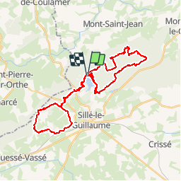
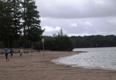
Randonnée V.T.T. de 43 km à découvrir à Pays de la Loire, Sarthe, Sillé-le-Guillaume. Cette randonnée est proposée par tracegps.
Description
Très joli cadre autour du lac de Sillé le Guillaume avec des portions très difficiles parfois. L'ensemble du circuit est réservé au VTTiste avertis. Le circuit se fait généralement dans une forêt de pins, avec quelques dénivelés importants.
Localisation
Pays :
France
Région :
Pays de la Loire
Département/Province :
Sarthe
Commune :
Sillé-le-Guillaume
Localité :
Unknown
Départ:(Dec)
Départ:(UTM)
713147 ; 5344000 (30U) N.
Commentaires
Randonnées à proximité
![Randonnée A pied Sillé-le-Guillaume - Tour du Grand Étang - Photo](https://media.geolcdn.com/t/375/260/7678a41d-26a8-4774-b077-be8b72792415.jpeg&format=jpg&maxdim=2)
![A pied A pied](https://static1.geolcdn.com/sitytour/trail-icons/100.png)
Tour du Grand Étang
A pied
Facile
Sillé-le-Guillaume,
Pays de la Loire,
Sarthe,
France
![](/images/other/stat-length.png)
3,8 km | 4,4 km-effort
1h 0min
![](https://static1.geolcdn.com/siteimages/upload/files/16400158638029165_repeat_loop_refresh_sync_direction_icon.png)
Oui
![Randonnée Marche Sillé-le-Guillaume - adal_stesuzanne 20160530 m - Photo](https://media.geolcdn.com/t/375/260/ext.jpg?maxdim=2&url=https%3A%2F%2Fstatic1.geolcdn.com%2Fsiteimages%2Fupload%2Ffiles%2F1553511878bg_sport_marche.png)
![Marche Marche](https://static1.geolcdn.com/sitytour/trail-icons/101.png)
adal_stesuzanne 20160530 m
Marche
Moyen
(1)
Sillé-le-Guillaume,
Pays de la Loire,
Sarthe,
France
![](/images/other/stat-length.png)
14,1 km | 17,1 km-effort
3h 42min
![](https://static1.geolcdn.com/siteimages/upload/files/16400158638029165_repeat_loop_refresh_sync_direction_icon.png)
Oui
![Randonnée Marche Sillé-le-Guillaume - 2 = Sillé le Guillaume - Fresnay sur Sarthe - Photo](https://media.geolcdn.com/t/375/260/4442b319-6958-42fe-a48c-ac594aca7731.jpg&format=jpg&maxdim=2)
![Marche Marche](https://static1.geolcdn.com/sitytour/trail-icons/101.png)
2 = Sillé le Guillaume - Fresnay sur Sarthe
Marche
Facile
Sillé-le-Guillaume,
Pays de la Loire,
Sarthe,
France
![](/images/other/stat-length.png)
28 km | 34 km-effort
5h 50min
![](https://static1.geolcdn.com/siteimages/upload/files/16400158638029165_repeat_loop_refresh_sync_direction_icon.png)
Non
![Randonnée Marche Mont-Saint-Jean - 1= Mont St Jean ~ Sillé le Guillaume - Photo](https://media.geolcdn.com/t/375/260/9d9d2a18-9e4c-4e8c-8ec5-aba24ab36bf2.jpg&format=jpg&maxdim=2)
![Marche Marche](https://static1.geolcdn.com/sitytour/trail-icons/101.png)
1= Mont St Jean ~ Sillé le Guillaume
Marche
Très facile
Mont-Saint-Jean,
Pays de la Loire,
Sarthe,
France
![](/images/other/stat-length.png)
9,1 km | 11,7 km-effort
1h 52min
![](https://static1.geolcdn.com/siteimages/upload/files/16400158638029165_repeat_loop_refresh_sync_direction_icon.png)
Non
![Randonnée A pied Saint-Germain-de-Coulamer - Sentier de Bel Air (b) - Photo](https://media.geolcdn.com/t/375/260/ext.jpg?maxdim=2&url=https%3A%2F%2Fstatic1.geolcdn.com%2Fsiteimages%2Fupload%2Ffiles%2F1545311037marcheuse_200dpi.jpg)
![A pied A pied](https://static1.geolcdn.com/sitytour/trail-icons/100.png)
Sentier de Bel Air (b)
A pied
Facile
Saint-Germain-de-Coulamer,
Pays de la Loire,
Mayenne,
France
![](/images/other/stat-length.png)
4,9 km | 6,3 km-effort
1h 25min
![](https://static1.geolcdn.com/siteimages/upload/files/16400158638029165_repeat_loop_refresh_sync_direction_icon.png)
Oui
![Randonnée V.T.T. Sillé-le-Guillaume - Autour du lac de Sillé le Guillaume - Photo](https://media.geolcdn.com/t/375/260/ext.jpg?maxdim=2&url=https%3A%2F%2Fservices.sitytrail.com%2FGeolivesWS%2FDownloadMedia.ashx%3FTrailID%3D103734%26Media%3D6401_1.jpg)
![V.T.T. V.T.T.](https://static1.geolcdn.com/sitytour/trail-icons/202.png)
Autour du lac de Sillé le Guillaume
V.T.T.
Difficile
Sillé-le-Guillaume,
Pays de la Loire,
Sarthe,
France
![](/images/other/stat-length.png)
33 km | 41 km-effort
3h 0min
![](https://static1.geolcdn.com/siteimages/upload/files/16400158638029165_repeat_loop_refresh_sync_direction_icon.png)
Oui
![Randonnée Marche Mont-Saint-Jean - Tour des Alpes Mancelles en 4 jours - Photo](https://media.geolcdn.com/t/375/260/ext.jpg?maxdim=2&url=https%3A%2F%2Fstatic1.geolcdn.com%2Fsiteimages%2Fupload%2Ffiles%2F1553511878bg_sport_marche.png)
![Marche Marche](https://static1.geolcdn.com/sitytour/trail-icons/101.png)
Tour des Alpes Mancelles en 4 jours
Marche
Facile
Mont-Saint-Jean,
Pays de la Loire,
Sarthe,
France
![](/images/other/stat-length.png)
87 km | 108 km-effort
17h 0min
![](https://static1.geolcdn.com/siteimages/upload/files/16400158638029165_repeat_loop_refresh_sync_direction_icon.png)
Oui
![Randonnée Marche nordique Sillé-le-Guillaume - Fr Coco plage. RS 16-01-2023 8,8 km - Photo](https://media.geolcdn.com/t/375/260/ext.jpg?maxdim=2&url=https%3A%2F%2Fstatic1.geolcdn.com%2Fsiteimages%2Fupload%2Ffiles%2F1545311037marcheuse_200dpi.jpg)
![Marche nordique Marche nordique](https://static1.geolcdn.com/sitytour/trail-icons/102.png)
Fr Coco plage. RS 16-01-2023 8,8 km
Marche nordique
Très facile
Sillé-le-Guillaume,
Pays de la Loire,
Sarthe,
France
![](/images/other/stat-length.png)
8,8 km | 10,4 km-effort
2h 1min
![](https://static1.geolcdn.com/siteimages/upload/files/16400158638029165_repeat_loop_refresh_sync_direction_icon.png)
Oui
![Randonnée V.T.T. Sillé-le-Guillaume - tour en forêt de Sillé. - Photo](https://media.geolcdn.com/t/375/260/ext.jpg?maxdim=2&url=https%3A%2F%2Fstatic1.geolcdn.com%2Fsiteimages%2Fupload%2Ffiles%2F1524743154velo.jpg)
![V.T.T. V.T.T.](https://static1.geolcdn.com/sitytour/trail-icons/202.png)
tour en forêt de Sillé.
V.T.T.
Moyen
Sillé-le-Guillaume,
Pays de la Loire,
Sarthe,
France
![](/images/other/stat-length.png)
22 km | 26 km-effort
1h 58min
![](https://static1.geolcdn.com/siteimages/upload/files/16400158638029165_repeat_loop_refresh_sync_direction_icon.png)
Oui