![](/images/other/stat-length.png)
![Randonnée A pied Zonza - bocca cinlindinu 1 2018 - Photo](https://media.geolcdn.com/t/1900/400/ext.pjpeg?maxdim=2&url=https%3A%2F%2Fstatic1.geolcdn.com%2Fsiteimages%2Fupload%2Ffiles%2F1545311037marcheuse_200dpi.jpg)
bocca cinlindinu 1 2018
philippenl
Utilisateur
![Longueur](/images/other/stat-length.png)
Longueur
9,4 km
![Altitude max](https://static1.geolcdn.com/siteimages/upload/files/1508320355ic_sort_altitude_max_24dp.png)
Altitude max
1427 m
![Dénivelé positif](https://static1.geolcdn.com/siteimages/upload/files/1508320355ic_sort_den_pos_24dp.png)
Dénivelé positif
488 m
![Km-Effort](/images/other/stat-length.png)
Km-Effort
15,9 km
![Altitude min](https://static1.geolcdn.com/siteimages/upload/files/1508320355ic_sort_altitude_min_24dp.png)
Altitude min
1001 m
![Dénivelé négatif](https://static1.geolcdn.com/siteimages/upload/files/1508320355ic_sort_den_neg_24dp.png)
Dénivelé négatif
487 m
![Boucle](https://static1.geolcdn.com/siteimages/upload/files/16400158638029165_repeat_loop_refresh_sync_direction_icon.png)
Boucle
Oui
Date de création :
2019-01-15 15:58:59.923
Dernière modification :
2019-12-14 13:29:21.016
![A pied](https://static1.geolcdn.com/sitytour/trail-icons/100.png)
--
Difficulté : Très facile
![Marche](https://static1.geolcdn.com/sitytour/trail-icons/101.png)
5h24
Difficulté : Inconnu
![Scannez ce code QR pour ouvrir la randonnée dans l'application SityTrail](https://capi.geolives.com/qq0zvz2zws4bq2lad0pu/sitytour/trails/1036810/qr.png?size=200)
Application GPS de randonnée GRATUITE
À propos
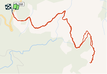
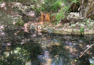
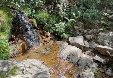
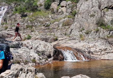
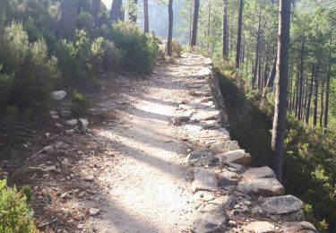
Randonnée A pied de 9,4 km à découvrir à Corse, Corse-du-Sud, Zonza. Cette randonnée est proposée par philippenl.
Description
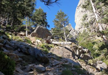
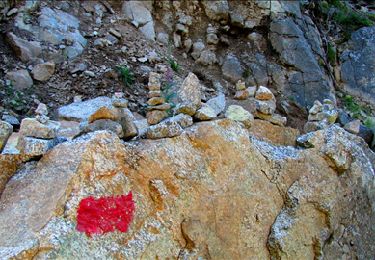
Progression à vue à partir de Bocca Fumicosa. Tâtonnements fréquents. Passages aériens possibles. Les changements météo peuvent être très rapides sur ces crêtes. Environnement exceptionnel.
Localisation
Pays :
France
Région :
Corse
Département/Province :
Corse-du-Sud
Commune :
Zonza
Localité :
Unknown
Départ:(Dec)
Départ:(UTM)
517238 ; 4624063 (32T) N.
Commentaires
Randonnées à proximité
![Randonnée Marche Zonza - Boucle du trou de la bombe - Bavella - Photo](https://media.geolcdn.com/t/375/260/ext.jpg?maxdim=2&url=https%3A%2F%2Fmedia.geolcdn.com%2Ff%2F57ec4c61-a922-4825-a53b-adb705edbd02.jpg)
![Marche Marche](https://static1.geolcdn.com/sitytour/trail-icons/101.png)
Boucle du trou de la bombe - Bavella
Marche
Facile
(1)
Zonza,
Corse,
Corse-du-Sud,
France
![](/images/other/stat-length.png)
6,5 km | 9 km-effort
1h 53min
![](https://static1.geolcdn.com/siteimages/upload/files/16400158638029165_repeat_loop_refresh_sync_direction_icon.png)
Oui
![Randonnée Marche Zonza - Bavella_trou de la bombe - Photo](https://media.geolcdn.com/t/375/260/ext.jpg?maxdim=2&url=https%3A%2F%2Fservices.sitytrail.com%2FGeolivesWS%2FDownloadMedia.ashx%3FTrailID%3D198331%26Media%3D1886eeb5-9e06-40d9-ad21-e8df8d175266.jpg)
![Marche Marche](https://static1.geolcdn.com/sitytour/trail-icons/101.png)
Bavella_trou de la bombe
Marche
Moyen
(1)
Zonza,
Corse,
Corse-du-Sud,
France
![](/images/other/stat-length.png)
7,7 km | 11,4 km-effort
3h 9min
![](https://static1.geolcdn.com/siteimages/upload/files/16400158638029165_repeat_loop_refresh_sync_direction_icon.png)
Oui
![Randonnée Marche Quenza - Les aiguilles de Bavella - Photo](https://media.geolcdn.com/t/375/260/ext.jpg?maxdim=2&url=https%3A%2F%2Fstatic1.geolcdn.com%2Fsiteimages%2Fupload%2Ffiles%2F1553511878bg_sport_marche.png)
![Marche Marche](https://static1.geolcdn.com/sitytour/trail-icons/101.png)
Les aiguilles de Bavella
Marche
Difficile
(2)
Quenza,
Corse,
Corse-du-Sud,
France
![](/images/other/stat-length.png)
14,1 km | 26 km-effort
4h 30min
![](https://static1.geolcdn.com/siteimages/upload/files/16400158638029165_repeat_loop_refresh_sync_direction_icon.png)
Oui
![Randonnée Marche Conca - Paliri Conca - Photo](https://media.geolcdn.com/t/375/260/ext.jpg?maxdim=2&url=https%3A%2F%2Fmedia.geolcdn.com%2Ff%2F8129a798-c8a0-4a1d-9b4b-9f49d3407a5a.jpg)
![Marche Marche](https://static1.geolcdn.com/sitytour/trail-icons/101.png)
Paliri Conca
Marche
Très difficile
Conca,
Corse,
Corse-du-Sud,
France
![](/images/other/stat-length.png)
13,5 km | 21 km-effort
4h 29min
![](https://static1.geolcdn.com/siteimages/upload/files/16400158638029165_repeat_loop_refresh_sync_direction_icon.png)
Non
![Randonnée Marche Conca - eta 2 - Photo](https://media.geolcdn.com/t/375/260/ext.jpg?maxdim=2&url=https%3A%2F%2Fmedia.geolcdn.com%2Ff%2F2e5824f5-cee9-4ee9-b75e-599680df0276.jpg)
![Marche Marche](https://static1.geolcdn.com/sitytour/trail-icons/101.png)
![Randonnée Marche Conca - Corse - GR20 Paliri à Conca - Photo](https://media.geolcdn.com/t/375/260/ext.jpg?maxdim=2&url=https%3A%2F%2Fmedia.geolcdn.com%2Ff%2F374a964b-6d4e-4e78-8a0e-bd563fc5fe7d.jpg)
![Marche Marche](https://static1.geolcdn.com/sitytour/trail-icons/101.png)
Corse - GR20 Paliri à Conca
Marche
Moyen
Conca,
Corse,
Corse-du-Sud,
France
![](/images/other/stat-length.png)
13,5 km | 21 km-effort
4h 30min
![](https://static1.geolcdn.com/siteimages/upload/files/16400158638029165_repeat_loop_refresh_sync_direction_icon.png)
Non
![Randonnée Marche Zonza - Trou de la bombe et Punta Velacu - Photo](https://media.geolcdn.com/t/375/260/ext.jpg?maxdim=2&url=https%3A%2F%2Fmedia.geolcdn.com%2Ff%2Fd5bb3da4-e374-49ec-b561-b8a65b36615c.jpg)
![Marche Marche](https://static1.geolcdn.com/sitytour/trail-icons/101.png)
Trou de la bombe et Punta Velacu
Marche
Facile
Zonza,
Corse,
Corse-du-Sud,
France
![](/images/other/stat-length.png)
9,4 km | 14,8 km-effort
4h 43min
![](https://static1.geolcdn.com/siteimages/upload/files/16400158638029165_repeat_loop_refresh_sync_direction_icon.png)
Oui
![Randonnée Marche Conca - GR20 Etape 15 Paliri Conca - Photo](https://media.geolcdn.com/t/375/260/ext.jpg?maxdim=2&url=https%3A%2F%2Fmedia.geolcdn.com%2Ff%2F6eca872c-e9ba-41e5-a4c7-e7ea694aaee8.jpg)
![Marche Marche](https://static1.geolcdn.com/sitytour/trail-icons/101.png)
GR20 Etape 15 Paliri Conca
Marche
Difficile
Conca,
Corse,
Corse-du-Sud,
France
![](/images/other/stat-length.png)
14 km | 21 km-effort
4h 53min
![](https://static1.geolcdn.com/siteimages/upload/files/16400158638029165_repeat_loop_refresh_sync_direction_icon.png)
Non
![Randonnée Marche Conca - .Gr 20 7ème jour - Photo](https://media.geolcdn.com/t/375/260/ext.jpg?maxdim=2&url=https%3A%2F%2Fservices.sitytrail.com%2FGeolivesWS%2FDownloadMedia.ashx%3FTrailID%3D984148%26Media%3Dfix__20180607095401.jpg)
![Marche Marche](https://static1.geolcdn.com/sitytour/trail-icons/101.png)
.Gr 20 7ème jour
Marche
Moyen
Conca,
Corse,
Corse-du-Sud,
France
![](/images/other/stat-length.png)
12,1 km | 18,9 km-effort
4h 18min
![](https://static1.geolcdn.com/siteimages/upload/files/16400158638029165_repeat_loop_refresh_sync_direction_icon.png)
Non