![](/images/other/stat-length.png)
![Randonnée V.T.T. Saint-Rémy-sur-Avre - Vallée de l' Avre - Photo](https://media.geolcdn.com/t/1900/400/ext.pjpeg?maxdim=2&url=https%3A%2F%2Fstatic1.geolcdn.com%2Fsiteimages%2Fupload%2Ffiles%2F1524743154velo.jpg)
Vallée de l' Avre
tracegps
Utilisateur
![Longueur](/images/other/stat-length.png)
Longueur
33 km
![Altitude max](https://static1.geolcdn.com/siteimages/upload/files/1508320355ic_sort_altitude_max_24dp.png)
Altitude max
146 m
![Dénivelé positif](https://static1.geolcdn.com/siteimages/upload/files/1508320355ic_sort_den_pos_24dp.png)
Dénivelé positif
503 m
![Km-Effort](/images/other/stat-length.png)
Km-Effort
40 km
![Altitude min](https://static1.geolcdn.com/siteimages/upload/files/1508320355ic_sort_altitude_min_24dp.png)
Altitude min
72 m
![Dénivelé négatif](https://static1.geolcdn.com/siteimages/upload/files/1508320355ic_sort_den_neg_24dp.png)
Dénivelé négatif
503 m
![Boucle](https://static1.geolcdn.com/siteimages/upload/files/16400158638029165_repeat_loop_refresh_sync_direction_icon.png)
Boucle
Oui
Date de création :
2014-12-10 00:00:00.0
Dernière modification :
2014-12-10 00:00:00.0
![V.T.T.](https://static1.geolcdn.com/sitytour/trail-icons/202.png)
2h00
Difficulté : Moyen
![Scannez ce code QR pour ouvrir la randonnée dans l'application SityTrail](https://capi.geolives.com/qq0zvz2zws4bq2lad0pu/sitytour/trails/103643/qr.png?size=200)
Application GPS de randonnée GRATUITE
À propos
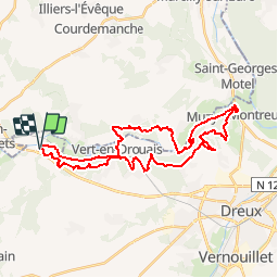
Randonnée V.T.T. de 33 km à découvrir à Centre-Val de Loire, Eure-et-Loir, Saint-Rémy-sur-Avre. Cette randonnée est proposée par tracegps.
Description
Parcours sympa en vallée de l'Avre avec quelque bosses sympas et un peu technique pour la region (on est quand meme pas en montagne)(auteur YOYONBIKE)
Localisation
Pays :
France
Région :
Centre-Val de Loire
Département/Province :
Eure-et-Loir
Commune :
Saint-Rémy-sur-Avre
Localité :
Unknown
Départ:(Dec)
Départ:(UTM)
370786 ; 5402517 (31U) N.
Commentaires
Randonnées à proximité
![Randonnée Marche Nonancourt - Balade des Crampons - Nonancourt - Photo](https://media.geolcdn.com/t/375/260/ext.jpg?maxdim=2&url=https%3A%2F%2Fservices.sitytrail.com%2FGeolivesWS%2FDownloadMedia.ashx%3FTrailID%3D112543%26Media%3D10752_6.jpg)
![Marche Marche](https://static1.geolcdn.com/sitytour/trail-icons/101.png)
Balade des Crampons - Nonancourt
Marche
Très difficile
(2)
Nonancourt,
Normandie,
Eure,
France
![](/images/other/stat-length.png)
17,5 km | 20 km-effort
4h 25min
![](https://static1.geolcdn.com/siteimages/upload/files/16400158638029165_repeat_loop_refresh_sync_direction_icon.png)
Oui
![Randonnée V.T.T. Saint-Rémy-sur-Avre - Les 3 ponts - Saint-Rémy-sur-Avre - Photo](https://media.geolcdn.com/t/375/260/ext.jpg?maxdim=2&url=https%3A%2F%2Fservices.sitytrail.com%2FGeolivesWS%2FDownloadMedia.ashx%3FTrailID%3D112565%26Media%3D10950_6.jpg)
![V.T.T. V.T.T.](https://static1.geolcdn.com/sitytour/trail-icons/202.png)
Les 3 ponts - Saint-Rémy-sur-Avre
V.T.T.
Facile
Saint-Rémy-sur-Avre,
Centre-Val de Loire,
Eure-et-Loir,
France
![](/images/other/stat-length.png)
16,1 km | 18,8 km-effort
2h 0min
![](https://static1.geolcdn.com/siteimages/upload/files/16400158638029165_repeat_loop_refresh_sync_direction_icon.png)
Oui
![Randonnée Marche Nonancourt - Nonancourt(Ouest)-Acon - Photo](https://media.geolcdn.com/t/375/260/ext.jpg?maxdim=2&url=https%3A%2F%2Fstatic1.geolcdn.com%2Fsiteimages%2Fupload%2Ffiles%2F1553511878bg_sport_marche.png)
![Marche Marche](https://static1.geolcdn.com/sitytour/trail-icons/101.png)
Nonancourt(Ouest)-Acon
Marche
Moyen
Nonancourt,
Normandie,
Eure,
France
![](/images/other/stat-length.png)
24 km | 27 km-effort
6h 0min
![](https://static1.geolcdn.com/siteimages/upload/files/16400158638029165_repeat_loop_refresh_sync_direction_icon.png)
Oui
![Randonnée Course à pied Saint-Lubin-des-Joncherets - Jogging 1h St Jacques de compostelle - Photo](https://media.geolcdn.com/t/375/260/ext.jpg?maxdim=2&url=https%3A%2F%2Fstatic1.geolcdn.com%2Fsiteimages%2Fupload%2Ffiles%2F1524743154running.jpg)
![Course à pied Course à pied](https://static1.geolcdn.com/sitytour/trail-icons/103.png)
Jogging 1h St Jacques de compostelle
Course à pied
Moyen
Saint-Lubin-des-Joncherets,
Centre-Val de Loire,
Eure-et-Loir,
France
![](/images/other/stat-length.png)
10,8 km | 12,5 km-effort
1h 15min
![](https://static1.geolcdn.com/siteimages/upload/files/16400158638029165_repeat_loop_refresh_sync_direction_icon.png)
Oui
![Randonnée Marche Nonancourt - nonancourt - Photo](https://media.geolcdn.com/t/375/260/ext.jpg?maxdim=2&url=https%3A%2F%2Fstatic1.geolcdn.com%2Fsiteimages%2Fupload%2Ffiles%2F1553511878bg_sport_marche.png)
![Marche Marche](https://static1.geolcdn.com/sitytour/trail-icons/101.png)
![Randonnée Marche Saint-Lubin-des-Joncherets - st Lubin - Photo](https://media.geolcdn.com/t/375/260/ext.jpg?maxdim=2&url=https%3A%2F%2Fstatic1.geolcdn.com%2Fsiteimages%2Fupload%2Ffiles%2F1553511878bg_sport_marche.png)
![Marche Marche](https://static1.geolcdn.com/sitytour/trail-icons/101.png)
st Lubin
Marche
Moyen
Saint-Lubin-des-Joncherets,
Centre-Val de Loire,
Eure-et-Loir,
France
![](/images/other/stat-length.png)
7,8 km | 9 km-effort
2h 2min
![](https://static1.geolcdn.com/siteimages/upload/files/16400158638029165_repeat_loop_refresh_sync_direction_icon.png)
Oui
![Randonnée Marche Mesnil-sur-l'Estrée - Marché 05 mai 2022 - Photo](https://media.geolcdn.com/t/375/260/ext.jpg?maxdim=2&url=https%3A%2F%2Fstatic1.geolcdn.com%2Fsiteimages%2Fupload%2Ffiles%2F1553511878bg_sport_marche.png)
![Marche Marche](https://static1.geolcdn.com/sitytour/trail-icons/101.png)
Marché 05 mai 2022
Marche
Moyen
Mesnil-sur-l'Estrée,
Normandie,
Eure,
France
![](/images/other/stat-length.png)
6,5 km | 7 km-effort
1h 41min
![](https://static1.geolcdn.com/siteimages/upload/files/16400158638029165_repeat_loop_refresh_sync_direction_icon.png)
Oui
![Randonnée Marche Mesnil-sur-l'Estrée - Domi 1 - Photo](https://media.geolcdn.com/t/375/260/ext.jpg?maxdim=2&url=https%3A%2F%2Fstatic1.geolcdn.com%2Fsiteimages%2Fupload%2Ffiles%2F1553511878bg_sport_marche.png)
![Marche Marche](https://static1.geolcdn.com/sitytour/trail-icons/101.png)
![Randonnée Marche Mesnil-sur-l'Estrée - 28 avril 2022 - Photo](https://media.geolcdn.com/t/375/260/ext.jpg?maxdim=2&url=https%3A%2F%2Fstatic1.geolcdn.com%2Fsiteimages%2Fupload%2Ffiles%2F1553511878bg_sport_marche.png)
![Marche Marche](https://static1.geolcdn.com/sitytour/trail-icons/101.png)
28 avril 2022
Marche
Facile
Mesnil-sur-l'Estrée,
Normandie,
Eure,
France
![](/images/other/stat-length.png)
5,3 km | 5,9 km-effort
1h 28min
![](https://static1.geolcdn.com/siteimages/upload/files/16400158638029165_repeat_loop_refresh_sync_direction_icon.png)
Non