![](/images/other/stat-length.png)
![Randonnée Marche Trégunc - St Philibert - Kersidan - Don - Trez Coa - Photo](https://media.geolcdn.com/t/1900/400/ext.pjpeg?maxdim=2&url=https%3A%2F%2Fstatic1.geolcdn.com%2Fsiteimages%2Fupload%2Ffiles%2F1553511878bg_sport_marche.png)
St Philibert - Kersidan - Don - Trez Coa
toporient
Utilisateur
![Longueur](/images/other/stat-length.png)
Longueur
4,1 km
![Altitude max](https://static1.geolcdn.com/siteimages/upload/files/1508320355ic_sort_altitude_max_24dp.png)
Altitude max
23 m
![Dénivelé positif](https://static1.geolcdn.com/siteimages/upload/files/1508320355ic_sort_den_pos_24dp.png)
Dénivelé positif
27 m
![Km-Effort](/images/other/stat-length.png)
Km-Effort
4,5 km
![Altitude min](https://static1.geolcdn.com/siteimages/upload/files/1508320355ic_sort_altitude_min_24dp.png)
Altitude min
1 m
![Dénivelé négatif](https://static1.geolcdn.com/siteimages/upload/files/1508320355ic_sort_den_neg_24dp.png)
Dénivelé négatif
29 m
![Boucle](https://static1.geolcdn.com/siteimages/upload/files/16400158638029165_repeat_loop_refresh_sync_direction_icon.png)
Boucle
Oui
Date de création :
2019-01-15 15:56:04.811
Dernière modification :
2019-01-15 15:56:04.811
![Marche](https://static1.geolcdn.com/sitytour/trail-icons/101.png)
59m
Difficulté : Facile
![Scannez ce code QR pour ouvrir la randonnée dans l'application SityTrail](https://capi.geolives.com/qq0zvz2zws4bq2lad0pu/sitytour/trails/1036313/qr.png?size=200)
Application GPS de randonnée GRATUITE
À propos
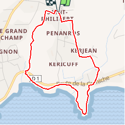
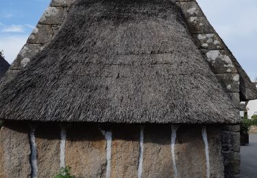
Randonnée Marche de 4,1 km à découvrir à Bretagne, Finistère, Trégunc. Cette randonnée est proposée par toporient.
Description
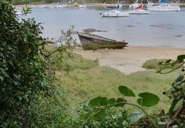
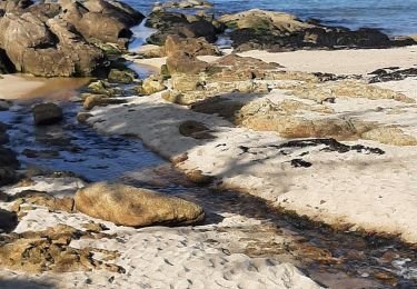
Circuit en boucle de l'église de st Philibert (dont 1,5 km en bord de mer) passant par les plages de Kersidan, du Don, de Trez Cao pour revenir par le chemin du parcours sportif.
Localisation
Pays :
France
Région :
Bretagne
Département/Province :
Finistère
Commune :
Trégunc
Localité :
Unknown
Départ:(Dec)
Départ:(UTM)
437661 ; 5295041 (30T) N.
Commentaires
Randonnées à proximité
![Randonnée Course à pied Trégunc - GR34 - 31 - Photo](https://media.geolcdn.com/t/375/260/ext.jpg?maxdim=2&url=https%3A%2F%2Fstatic1.geolcdn.com%2Fsiteimages%2Fupload%2Ffiles%2F1524743154running.jpg)
![Course à pied Course à pied](https://static1.geolcdn.com/sitytour/trail-icons/103.png)
GR34 - 31
Course à pied
Moyen
(1)
Trégunc,
Bretagne,
Finistère,
France
![](/images/other/stat-length.png)
42 km | 47 km-effort
6h 0min
![](https://static1.geolcdn.com/siteimages/upload/files/16400158638029165_repeat_loop_refresh_sync_direction_icon.png)
Non
![Randonnée Marche Névez - Samedi 4 novembre 2012 - Photo](https://media.geolcdn.com/t/375/260/ext.jpg?maxdim=2&url=https%3A%2F%2Fstatic1.geolcdn.com%2Fsiteimages%2Fupload%2Ffiles%2F1553511878bg_sport_marche.png)
![Marche Marche](https://static1.geolcdn.com/sitytour/trail-icons/101.png)
Samedi 4 novembre 2012
Marche
Très facile
(1)
Névez,
Bretagne,
Finistère,
France
![](/images/other/stat-length.png)
6,6 km | 7,2 km-effort
1h 16min
![](https://static1.geolcdn.com/siteimages/upload/files/16400158638029165_repeat_loop_refresh_sync_direction_icon.png)
Oui
![Randonnée Marche Trégunc - Randonnee de Trévignon - Trégunc - Photo](https://media.geolcdn.com/t/375/260/ext.jpg?maxdim=2&url=https%3A%2F%2Fstatic1.geolcdn.com%2Fsiteimages%2Fupload%2Ffiles%2F1553511878bg_sport_marche.png)
![Marche Marche](https://static1.geolcdn.com/sitytour/trail-icons/101.png)
Randonnee de Trévignon - Trégunc
Marche
Facile
(2)
Trégunc,
Bretagne,
Finistère,
France
![](/images/other/stat-length.png)
6,7 km | 7,3 km-effort
1h 45min
![](https://static1.geolcdn.com/siteimages/upload/files/16400158638029165_repeat_loop_refresh_sync_direction_icon.png)
Oui
![Randonnée Marche Trégunc - Yregunc re ar wenodenn - Photo](https://media.geolcdn.com/t/375/260/920b2546-d768-4de0-82fe-cbd6fddcfc28.jpg&format=jpg&maxdim=2)
![Marche Marche](https://static1.geolcdn.com/sitytour/trail-icons/101.png)
Yregunc re ar wenodenn
Marche
Facile
Trégunc,
Bretagne,
Finistère,
France
![](/images/other/stat-length.png)
5,8 km | 6,2 km-effort
1h 33min
![](https://static1.geolcdn.com/siteimages/upload/files/16400158638029165_repeat_loop_refresh_sync_direction_icon.png)
Oui
![Randonnée Marche Trégunc - Saint Philibert-Trévignon plage - Photo](https://media.geolcdn.com/t/375/260/cebc81cb-da8e-476d-ba58-36b6f4cdb247.jpg&format=jpg&maxdim=2)
![Marche Marche](https://static1.geolcdn.com/sitytour/trail-icons/101.png)
Saint Philibert-Trévignon plage
Marche
Moyen
Trégunc,
Bretagne,
Finistère,
France
![](/images/other/stat-length.png)
7,1 km | 7,7 km-effort
1h 55min
![](https://static1.geolcdn.com/siteimages/upload/files/16400158638029165_repeat_loop_refresh_sync_direction_icon.png)
Oui
![Randonnée Marche Trégunc - TREGUNC - Photo](https://media.geolcdn.com/t/375/260/04a90680-2ce4-46fa-965d-80bc63343dd4.jpg&format=jpg&maxdim=2)
![Marche Marche](https://static1.geolcdn.com/sitytour/trail-icons/101.png)
![Randonnée Marche Trégunc - Tregunc - Photo](https://media.geolcdn.com/t/375/260/0294ed77-693d-4112-8e2e-97085a77d8cd.jpg&format=jpg&maxdim=2)
![Marche Marche](https://static1.geolcdn.com/sitytour/trail-icons/101.png)
![Randonnée Marche Névez - Kerascoët- Plage de Tahiti-Raguenez - Photo](https://media.geolcdn.com/t/375/260/eb9238df-9db1-4408-903e-0787f78f91db.jpg&format=jpg&maxdim=2)
![Marche Marche](https://static1.geolcdn.com/sitytour/trail-icons/101.png)
Kerascoët- Plage de Tahiti-Raguenez
Marche
Très facile
Névez,
Bretagne,
Finistère,
France
![](/images/other/stat-length.png)
3,8 km | 4,3 km-effort
2h 34min
![](https://static1.geolcdn.com/siteimages/upload/files/16400158638029165_repeat_loop_refresh_sync_direction_icon.png)
Oui
![Randonnée Marche Névez - Rospico, Trémorvézen, Kercvaillet, Plage Tahiti et retour par bord de mer - Photo](https://media.geolcdn.com/t/375/260/ext.jpg?maxdim=2&url=https%3A%2F%2Fstatic1.geolcdn.com%2Fsiteimages%2Fupload%2Ffiles%2F1553511878bg_sport_marche.png)
![Marche Marche](https://static1.geolcdn.com/sitytour/trail-icons/101.png)
Rospico, Trémorvézen, Kercvaillet, Plage Tahiti et retour par bord de mer
Marche
Très facile
(1)
Névez,
Bretagne,
Finistère,
France
![](/images/other/stat-length.png)
7 km | 7,8 km-effort
2h 0min
![](https://static1.geolcdn.com/siteimages/upload/files/16400158638029165_repeat_loop_refresh_sync_direction_icon.png)
Oui