![](/images/other/stat-length.png)
![Randonnée V.T.T. Montrevault-sur-Èvre - Mont Rebel - Photo](https://media.geolcdn.com/t/1900/400/ext.pjpeg?maxdim=2&url=https%3A%2F%2Fstatic1.geolcdn.com%2Fsiteimages%2Fupload%2Ffiles%2F1524743154velo.jpg)
Mont Rebel
tracegps
Utilisateur
![Longueur](/images/other/stat-length.png)
Longueur
19,9 km
![Altitude max](https://static1.geolcdn.com/siteimages/upload/files/1508320355ic_sort_altitude_max_24dp.png)
Altitude max
104 m
![Dénivelé positif](https://static1.geolcdn.com/siteimages/upload/files/1508320355ic_sort_den_pos_24dp.png)
Dénivelé positif
384 m
![Km-Effort](/images/other/stat-length.png)
Km-Effort
25 km
![Altitude min](https://static1.geolcdn.com/siteimages/upload/files/1508320355ic_sort_altitude_min_24dp.png)
Altitude min
27 m
![Dénivelé négatif](https://static1.geolcdn.com/siteimages/upload/files/1508320355ic_sort_den_neg_24dp.png)
Dénivelé négatif
386 m
![Boucle](https://static1.geolcdn.com/siteimages/upload/files/16400158638029165_repeat_loop_refresh_sync_direction_icon.png)
Boucle
Oui
Date de création :
2014-12-10 00:00:00.0
Dernière modification :
2014-12-10 00:00:00.0
![V.T.T.](https://static1.geolcdn.com/sitytour/trail-icons/202.png)
1h30
Difficulté : Difficile
![Scannez ce code QR pour ouvrir la randonnée dans l'application SityTrail](https://capi.geolives.com/qq0zvz2zws4bq2lad0pu/sitytour/trails/103581/qr.png?size=200)
Application GPS de randonnée GRATUITE
À propos
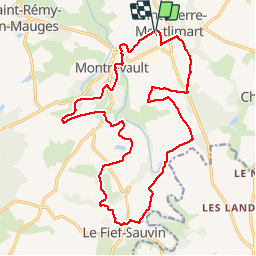
Randonnée V.T.T. de 19,9 km à découvrir à Pays de la Loire, Maine-et-Loire, Montrevault-sur-Èvre. Cette randonnée est proposée par tracegps.
Description
Boucle de 21Km au départ de St Pierre Montlimart. Un circuit qui peut être assez gras en hiver, offrant de jolis points de vue. Le dénivelé est assez important (530m approx.) donc à déconseiller si vous avez des enfants ou un petit niveau.
Localisation
Pays :
France
Région :
Pays de la Loire
Département/Province :
Maine-et-Loire
Commune :
Montrevault-sur-Èvre
Localité :
Unknown
Départ:(Dec)
Départ:(UTM)
648970 ; 5236858 (30T) N.
Commentaires
Randonnées à proximité
![Randonnée Marche Montrevault-sur-Èvre - le moulin du GOUAS ST Pierre Montlimart - Photo](https://media.geolcdn.com/t/375/260/0d3570cf-5fa9-42fc-9d02-ee9b967646f2.jpg&format=jpg&maxdim=2)
![Marche Marche](https://static1.geolcdn.com/sitytour/trail-icons/101.png)
le moulin du GOUAS ST Pierre Montlimart
Marche
Moyen
Montrevault-sur-Èvre,
Pays de la Loire,
Maine-et-Loire,
France
![](/images/other/stat-length.png)
8,2 km | 9,8 km-effort
2h 31min
![](https://static1.geolcdn.com/siteimages/upload/files/16400158638029165_repeat_loop_refresh_sync_direction_icon.png)
Oui
![Randonnée Marche Montrevault-sur-Èvre - St Rémy en mauges - Photo](https://media.geolcdn.com/t/375/260/bdbe4416-8aff-4641-bf20-65247de902cd.jpg&format=jpg&maxdim=2)
![Marche Marche](https://static1.geolcdn.com/sitytour/trail-icons/101.png)
St Rémy en mauges
Marche
Difficile
Montrevault-sur-Èvre,
Pays de la Loire,
Maine-et-Loire,
France
![](/images/other/stat-length.png)
28 km | 34 km-effort
5h 22min
![](https://static1.geolcdn.com/siteimages/upload/files/16400158638029165_repeat_loop_refresh_sync_direction_icon.png)
Oui
![Randonnée Marche Montrevault-sur-Èvre - Montrevault - Photo](https://media.geolcdn.com/t/375/260/ext.jpg?maxdim=2&url=https%3A%2F%2Fstatic1.geolcdn.com%2Fsiteimages%2Fupload%2Ffiles%2F1553511878bg_sport_marche.png)
![Marche Marche](https://static1.geolcdn.com/sitytour/trail-icons/101.png)
Montrevault
Marche
Facile
Montrevault-sur-Èvre,
Pays de la Loire,
Maine-et-Loire,
France
![](/images/other/stat-length.png)
8,7 km | 10,8 km-effort
2h 19min
![](https://static1.geolcdn.com/siteimages/upload/files/16400158638029165_repeat_loop_refresh_sync_direction_icon.png)
Oui
![Randonnée Marche Mauges-sur-Loire - Botz en Mauges - Photo](https://media.geolcdn.com/t/375/260/ext.jpg?maxdim=2&url=https%3A%2F%2Fstatic1.geolcdn.com%2Fsiteimages%2Fupload%2Ffiles%2F1553511878bg_sport_marche.png)
![Marche Marche](https://static1.geolcdn.com/sitytour/trail-icons/101.png)
Botz en Mauges
Marche
Facile
Mauges-sur-Loire,
Pays de la Loire,
Maine-et-Loire,
France
![](/images/other/stat-length.png)
11,1 km | 13,3 km-effort
3h 4min
![](https://static1.geolcdn.com/siteimages/upload/files/16400158638029165_repeat_loop_refresh_sync_direction_icon.png)
Oui
![Randonnée Marche Montrevault-sur-Èvre - Du Buis à la Trezenne-La Boissiere sur Evre - Photo](https://media.geolcdn.com/t/375/260/ext.jpg?maxdim=2&url=https%3A%2F%2Fstatic1.geolcdn.com%2Fsiteimages%2Fupload%2Ffiles%2F1553511878bg_sport_marche.png)
![Marche Marche](https://static1.geolcdn.com/sitytour/trail-icons/101.png)
Du Buis à la Trezenne-La Boissiere sur Evre
Marche
Moyen
Montrevault-sur-Èvre,
Pays de la Loire,
Maine-et-Loire,
France
![](/images/other/stat-length.png)
15 km | 17,6 km-effort
3h 56min
![](https://static1.geolcdn.com/siteimages/upload/files/16400158638029165_repeat_loop_refresh_sync_direction_icon.png)
Oui
![Randonnée Marche Mauges-sur-Loire - Au fil du St Laurent - Photo](https://media.geolcdn.com/t/375/260/ext.jpg?maxdim=2&url=https%3A%2F%2Fstatic1.geolcdn.com%2Fsiteimages%2Fupload%2Ffiles%2F1553511878bg_sport_marche.png)
![Marche Marche](https://static1.geolcdn.com/sitytour/trail-icons/101.png)
Au fil du St Laurent
Marche
Facile
Mauges-sur-Loire,
Pays de la Loire,
Maine-et-Loire,
France
![](/images/other/stat-length.png)
9,4 km | 11,2 km-effort
2h 27min
![](https://static1.geolcdn.com/siteimages/upload/files/16400158638029165_repeat_loop_refresh_sync_direction_icon.png)
Oui
![Randonnée Marche Montrevault-sur-Èvre - variante St jacques de Compostelle Montrevault-Beaupréau - Photo](https://media.geolcdn.com/t/375/260/ext.jpg?maxdim=2&url=https%3A%2F%2Fstatic1.geolcdn.com%2Fsiteimages%2Fupload%2Ffiles%2F1553511878bg_sport_marche.png)
![Marche Marche](https://static1.geolcdn.com/sitytour/trail-icons/101.png)
variante St jacques de Compostelle Montrevault-Beaupréau
Marche
Moyen
Montrevault-sur-Èvre,
Pays de la Loire,
Maine-et-Loire,
France
![](/images/other/stat-length.png)
19 km | 24 km-effort
5h 8min
![](https://static1.geolcdn.com/siteimages/upload/files/16400158638029165_repeat_loop_refresh_sync_direction_icon.png)
Non
![Randonnée Marche Montrevault-sur-Èvre - Montrevault 3 - Photo](https://media.geolcdn.com/t/375/260/ext.jpg?maxdim=2&url=https%3A%2F%2Fstatic1.geolcdn.com%2Fsiteimages%2Fupload%2Ffiles%2F1553511878bg_sport_marche.png)
![Marche Marche](https://static1.geolcdn.com/sitytour/trail-icons/101.png)
Montrevault 3
Marche
Très facile
Montrevault-sur-Èvre,
Pays de la Loire,
Maine-et-Loire,
France
![](/images/other/stat-length.png)
17 km | 21 km-effort
4h 39min
![](https://static1.geolcdn.com/siteimages/upload/files/16400158638029165_repeat_loop_refresh_sync_direction_icon.png)
Oui
![Randonnée Marche Montrevault-sur-Èvre - St Rémy-Montrevault - Photo](https://media.geolcdn.com/t/375/260/ext.jpg?maxdim=2&url=https%3A%2F%2Fstatic1.geolcdn.com%2Fsiteimages%2Fupload%2Ffiles%2F1553511878bg_sport_marche.png)
![Marche Marche](https://static1.geolcdn.com/sitytour/trail-icons/101.png)
St Rémy-Montrevault
Marche
Facile
Montrevault-sur-Èvre,
Pays de la Loire,
Maine-et-Loire,
France
![](/images/other/stat-length.png)
9 km | 11 km-effort
2h 22min
![](https://static1.geolcdn.com/siteimages/upload/files/16400158638029165_repeat_loop_refresh_sync_direction_icon.png)
Oui