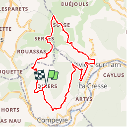
![](/images/other/stat-length.png)
![Randonnée V.T.T. Compeyre - Balade autour de Compeyre dans la vallée du Tarn - Photo](https://media.geolcdn.com/t/1900/400/ext.pjpeg?maxdim=2&url=https%3A%2F%2Fservices.sitytrail.com%2FGeolivesWS%2FDownloadMedia.ashx%3FTrailID%3D103569%26Media%3D5871_1.jpg)
Balade autour de Compeyre dans la vallée du Tarn
tracegps
Utilisateur
![Longueur](/images/other/stat-length.png)
![Altitude max](https://static1.geolcdn.com/siteimages/upload/files/1508320355ic_sort_altitude_max_24dp.png)
![Dénivelé positif](https://static1.geolcdn.com/siteimages/upload/files/1508320355ic_sort_den_pos_24dp.png)
![Km-Effort](/images/other/stat-length.png)
![Altitude min](https://static1.geolcdn.com/siteimages/upload/files/1508320355ic_sort_altitude_min_24dp.png)
![Dénivelé négatif](https://static1.geolcdn.com/siteimages/upload/files/1508320355ic_sort_den_neg_24dp.png)
![Boucle](https://static1.geolcdn.com/siteimages/upload/files/16400158638029165_repeat_loop_refresh_sync_direction_icon.png)
![V.T.T.](https://static1.geolcdn.com/sitytour/trail-icons/202.png)
2h10
Difficulté : Difficile
![Scannez ce code QR pour ouvrir la randonnée dans l'application SityTrail](https://capi.geolives.com/qq0zvz2zws4bq2lad0pu/sitytour/trails/103569/qr.png?size=200)
Application GPS de randonnée GRATUITE
À propos
Randonnée V.T.T. de 21 km à découvrir à Occitanie, Aveyron, Compeyre. Cette randonnée est proposée par tracegps.
Description
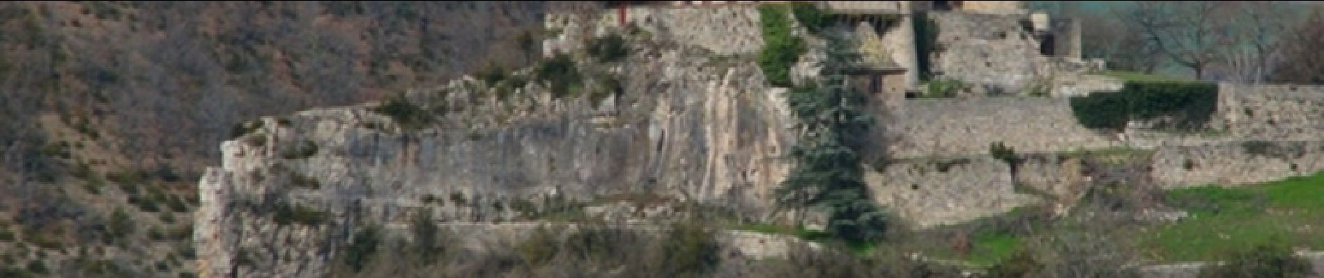
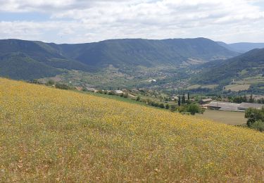
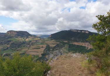
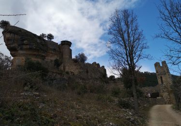
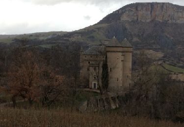
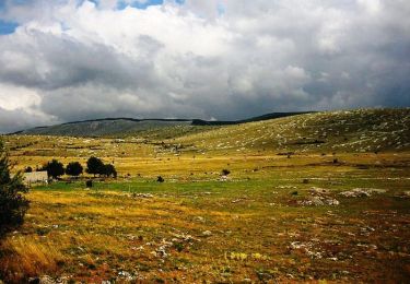
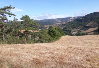
La randonnée est une jolie boucle de 20 Km environ près d'un très beau village de la Vallée du Tarn: Compeyre. Pendant la promenade, on peut admirer plusieurs Châteaux (Cabrières, Lugagnac) ainsi que de très beau paysage Aveyronnais et la vue sur le Tarn. Nous sommes partis de l'Auberge de Quiers, mais on peut partir du village de Compeyre. La balade n'est pas très difficile, mais il y a quelques belles descentes et montées, le terrain était sec et caillouteux, quelques passages techniques, mais rien de bien méchant. Engagement moyen, éviter de faire cette balade en plein cagnard. Nous avons eu la chance de voir des nuées de vautours ( de 100) qui tournoyaient près du Château de Cabrière, c'est impressionnant, il ne faut pas tomber dans un ravin car "miam-miam les oiseaux...". Il y aussi quelques coins à fossiles
Localisation
Commentaires
Randonnées à proximité
![Randonnée Marche Rivière-sur-Tarn - Rivière-sur-Tarn - Château Peyrelade - 9.9km 400m 3h30 (40mn) - 2016 09 09 - Photo](https://media.geolcdn.com/t/375/260/ext.jpg?maxdim=2&url=https%3A%2F%2Fservices.sitytrail.com%2FGeolivesWS%2FDownloadMedia.ashx%3FTrailID%3D629408%26Media%3Dfix__20160909102534.jpg)
![Marche Marche](https://static1.geolcdn.com/sitytour/trail-icons/101.png)
Marche
![](/images/other/stat-length.png)
![](https://static1.geolcdn.com/siteimages/upload/files/16400158638029165_repeat_loop_refresh_sync_direction_icon.png)
![Randonnée Marche Rivière-sur-Tarn - Fontaneilles, château de Peyrerade, Piedestal - Photo](https://media.geolcdn.com/t/375/260/6158451c-494b-4a64-9baa-82ef21462db8.jpg&format=jpg&maxdim=2)
![Marche Marche](https://static1.geolcdn.com/sitytour/trail-icons/101.png)
Marche
![](/images/other/stat-length.png)
![](https://static1.geolcdn.com/siteimages/upload/files/16400158638029165_repeat_loop_refresh_sync_direction_icon.png)
![Randonnée Marche La Cresse - la cresse, belvédère de caylus - Photo](https://media.geolcdn.com/t/375/260/be8188b9-8784-481e-a93b-947b479ff544.jpg&format=jpg&maxdim=2)
![Marche Marche](https://static1.geolcdn.com/sitytour/trail-icons/101.png)
Marche
![](/images/other/stat-length.png)
![](https://static1.geolcdn.com/siteimages/upload/files/16400158638029165_repeat_loop_refresh_sync_direction_icon.png)
![Randonnée Marche Rivière-sur-Tarn - Puech de Fontaneilles - Photo](https://media.geolcdn.com/t/375/260/675400ba-67d4-4727-bd77-e9bcfa17dfaa.jpg&format=jpg&maxdim=2)
![Marche Marche](https://static1.geolcdn.com/sitytour/trail-icons/101.png)
Marche
![](/images/other/stat-length.png)
![](https://static1.geolcdn.com/siteimages/upload/files/16400158638029165_repeat_loop_refresh_sync_direction_icon.png)
![Randonnée Marche Compeyre - les 3 chateaux - Photo](https://media.geolcdn.com/t/375/260/ext.jpg?maxdim=2&url=https%3A%2F%2Fservices.sitytrail.com%2FGeolivesWS%2FDownloadMedia.ashx%3FTrailID%3D173336%26Media%3D20130131161114.jpg)
![Marche Marche](https://static1.geolcdn.com/sitytour/trail-icons/101.png)
Marche
![](/images/other/stat-length.png)
![](https://static1.geolcdn.com/siteimages/upload/files/16400158638029165_repeat_loop_refresh_sync_direction_icon.png)
![Randonnée V.T.T. Aguessac - GéoBike - Tour des Grands Causses - édition 2009 - Photo](https://media.geolcdn.com/t/375/260/ext.jpg?maxdim=2&url=https%3A%2F%2Fservices.sitytrail.com%2FGeolivesWS%2FDownloadMedia.ashx%3FTrailID%3D103871%26Media%3D6675_4.jpg)
![V.T.T. V.T.T.](https://static1.geolcdn.com/sitytour/trail-icons/202.png)
V.T.T.
![](/images/other/stat-length.png)
![](https://static1.geolcdn.com/siteimages/upload/files/16400158638029165_repeat_loop_refresh_sync_direction_icon.png)
![Randonnée Marche Rivière-sur-Tarn - 2019-08-28 Puech de Fontaneilles - Photo](https://media.geolcdn.com/t/375/260/3da1002f-bd7b-430f-8381-1a5d79e4be55.jpg&format=jpg&maxdim=2)
![Marche Marche](https://static1.geolcdn.com/sitytour/trail-icons/101.png)
Marche
![](/images/other/stat-length.png)
![](https://static1.geolcdn.com/siteimages/upload/files/16400158638029165_repeat_loop_refresh_sync_direction_icon.png)
![Randonnée Marche Rivière-sur-Tarn - 2019-08-26 Château de Lugagnac - Photo](https://media.geolcdn.com/t/375/260/df758779-1865-4020-809d-6ce9b7e020ff.jpg&format=jpg&maxdim=2)
![Marche Marche](https://static1.geolcdn.com/sitytour/trail-icons/101.png)
Marche
![](/images/other/stat-length.png)
![](https://static1.geolcdn.com/siteimages/upload/files/16400158638029165_repeat_loop_refresh_sync_direction_icon.png)
![Randonnée Marche Rivière-sur-Tarn - Massagal - Photo](https://media.geolcdn.com/t/375/260/771d3144-4929-42f4-bbaa-365a3c368890.jpg&format=jpg&maxdim=2)
![Marche Marche](https://static1.geolcdn.com/sitytour/trail-icons/101.png)
Marche
![](/images/other/stat-length.png)
![](https://static1.geolcdn.com/siteimages/upload/files/16400158638029165_repeat_loop_refresh_sync_direction_icon.png)