![](/images/other/stat-length.png)
![Randonnée Marche Ontex - La Charvaz 1158m, depuis Grumeau (Ontex) - Photo](https://media.geolcdn.com/t/1900/400/ext.pjpeg?maxdim=2&url=https%3A%2F%2Fservices.sitytrail.com%2FGeolivesWS%2FDownloadMedia.ashx%3FTrailID%3D103530%26Media%3D5727_1.jpg)
La Charvaz 1158m, depuis Grumeau (Ontex)
tracegps
Utilisateur
![Longueur](/images/other/stat-length.png)
![Altitude max](https://static1.geolcdn.com/siteimages/upload/files/1508320355ic_sort_altitude_max_24dp.png)
![Dénivelé positif](https://static1.geolcdn.com/siteimages/upload/files/1508320355ic_sort_den_pos_24dp.png)
![Km-Effort](/images/other/stat-length.png)
![Altitude min](https://static1.geolcdn.com/siteimages/upload/files/1508320355ic_sort_altitude_min_24dp.png)
![Dénivelé négatif](https://static1.geolcdn.com/siteimages/upload/files/1508320355ic_sort_den_neg_24dp.png)
![Boucle](https://static1.geolcdn.com/siteimages/upload/files/16400158638029165_repeat_loop_refresh_sync_direction_icon.png)
![Marche](https://static1.geolcdn.com/sitytour/trail-icons/101.png)
3h15
Difficulté : Facile
![Scannez ce code QR pour ouvrir la randonnée dans l'application SityTrail](https://capi.geolives.com/qq0zvz2zws4bq2lad0pu/sitytour/trails/103530/qr.png?size=200)
Application GPS de randonnée GRATUITE
À propos
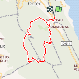
Randonnée Marche de 8,4 km à découvrir à Auvergne-Rhône-Alpes, Savoie, Ontex. Cette randonnée est proposée par tracegps.
Description
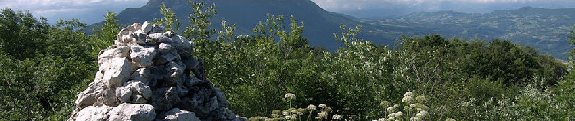
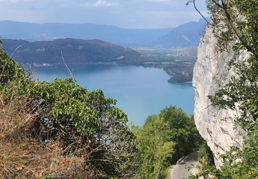
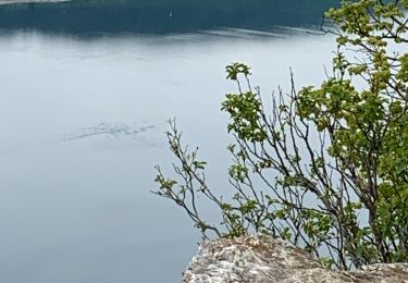
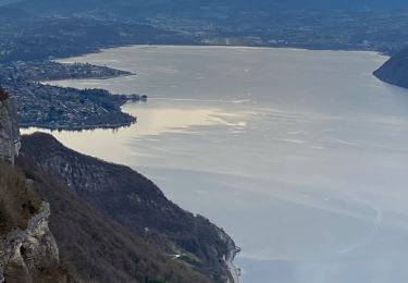
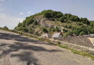
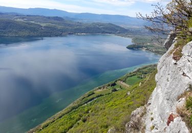
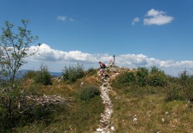
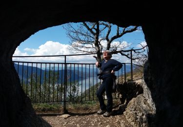
Grumeau, hameau de Ontex au dessus du Lac du Bourget, domine l'Abbaye Royale de Hautecombe. C'est un autre point de départ pour une randonnée en boucle par la cime de la Charvaz. Le Mont de la Charvaz, située au Nord du Col du Chat, domine à l'Est le Lac du Bourget et le pays de Yenne à l'Ouest. Souvent sous le couvert de la forêt, le parcours emprunte des vieux sentiers et des pistes par toujours évidentes à suivre – cartes et boussole obligatoires ! Description complète sur sentier-nature.com : La Charvaz 1158m, depuis Grumeau (Ontex)
Localisation
Commentaires
Randonnées à proximité
![Randonnée Marche Entrelacs - 30-08-2022 La Chambotte - Croix de Meyrieu - Photo](https://media.geolcdn.com/t/375/260/c8704b3f-8048-446a-89ef-a79ba6fd2504.jpg&format=jpg&maxdim=2)
![Marche Marche](https://static1.geolcdn.com/sitytour/trail-icons/101.png)
Marche
![](/images/other/stat-length.png)
![](https://static1.geolcdn.com/siteimages/upload/files/16400158638029165_repeat_loop_refresh_sync_direction_icon.png)
![Randonnée Marche Entrelacs - Belvédère de la Chambotte - Mont de Corsuet - Photo](https://media.geolcdn.com/t/375/260/320ab627-8a91-46ea-b3a7-34db91702556.jpg&format=jpg&maxdim=2)
![Marche Marche](https://static1.geolcdn.com/sitytour/trail-icons/101.png)
Marche
![](/images/other/stat-length.png)
![](https://static1.geolcdn.com/siteimages/upload/files/16400158638029165_repeat_loop_refresh_sync_direction_icon.png)
![Randonnée Marche Entrelacs - La chambotte mont laval aix les bains - Photo](https://media.geolcdn.com/t/375/260/83780321-69f1-4ca1-9229-55e6ffa1c410.jpg&format=jpg&maxdim=2)
![Marche Marche](https://static1.geolcdn.com/sitytour/trail-icons/101.png)
Marche
![](/images/other/stat-length.png)
![](https://static1.geolcdn.com/siteimages/upload/files/16400158638029165_repeat_loop_refresh_sync_direction_icon.png)
![Randonnée Marche Entrelacs - Bellevedere de la Chambotte - Photo](https://media.geolcdn.com/t/375/260/69045582-c557-4058-9efb-585a49f48118.jpg&format=jpg&maxdim=2)
![Marche Marche](https://static1.geolcdn.com/sitytour/trail-icons/101.png)
Marche
![](/images/other/stat-length.png)
![](https://static1.geolcdn.com/siteimages/upload/files/16400158638029165_repeat_loop_refresh_sync_direction_icon.png)
![Randonnée Marche Entrelacs - CHAMBOTTE: DECRASSAGE SUR LES CRETES - Photo](https://media.geolcdn.com/t/375/260/ddde69c3-3462-4077-ba6c-e835ee2db56d.jpg&format=jpg&maxdim=2)
![Marche Marche](https://static1.geolcdn.com/sitytour/trail-icons/101.png)
Marche
![](/images/other/stat-length.png)
![](https://static1.geolcdn.com/siteimages/upload/files/16400158638029165_repeat_loop_refresh_sync_direction_icon.png)
![Randonnée Marche Entrelacs - La Chambotte - Photo](https://media.geolcdn.com/t/375/260/54b00156-aea0-4e56-847d-f6d0a544d754.jpg&format=jpg&maxdim=2)
![Marche Marche](https://static1.geolcdn.com/sitytour/trail-icons/101.png)
Marche
![](/images/other/stat-length.png)
![](https://static1.geolcdn.com/siteimages/upload/files/16400158638029165_repeat_loop_refresh_sync_direction_icon.png)
![Randonnée Marche Ontex - MONT DE LA CHARVAZ: POINT GEODESIQUE DE LA CHARVAZ - Photo](https://media.geolcdn.com/t/375/260/c02ada1f-5da7-42d1-9b0b-f7ee1aec644e.jpg&format=jpg&maxdim=2)
![Marche Marche](https://static1.geolcdn.com/sitytour/trail-icons/101.png)
Marche
![](/images/other/stat-length.png)
![](https://static1.geolcdn.com/siteimages/upload/files/16400158638029165_repeat_loop_refresh_sync_direction_icon.png)
![Randonnée Marche Entrelacs - MONT DE CORSUET: CHAMBOTTE - GROTTE DES FEES - MEYRIEUX (retour par les crêtes) - Photo](https://media.geolcdn.com/t/375/260/0c50d685-d075-41b0-b8b2-19210294885b.jpg&format=jpg&maxdim=2)
![Marche Marche](https://static1.geolcdn.com/sitytour/trail-icons/101.png)
Marche
![](/images/other/stat-length.png)
![](https://static1.geolcdn.com/siteimages/upload/files/16400158638029165_repeat_loop_refresh_sync_direction_icon.png)
![Randonnée Marche Brison-Saint-Innocent - Brison-Chambotte-Cx Meyrieu - Photo](https://media.geolcdn.com/t/375/260/ext.jpg?maxdim=2&url=https%3A%2F%2Fservices.sitytrail.com%2FGeolivesWS%2FDownloadMedia.ashx%3FTrailID%3D668797%26Media%3D20161205130707.jpg)
![Marche Marche](https://static1.geolcdn.com/sitytour/trail-icons/101.png)
Marche
![](/images/other/stat-length.png)
![](https://static1.geolcdn.com/siteimages/upload/files/16400158638029165_repeat_loop_refresh_sync_direction_icon.png)