![](/images/other/stat-length.png)
![Randonnée V.T.T. Besançon - Chemins du Sud de Besançon - Photo](https://media.geolcdn.com/t/1900/400/ext.pjpeg?maxdim=2&url=https%3A%2F%2Fservices.sitytrail.com%2FGeolivesWS%2FDownloadMedia.ashx%3FTrailID%3D103497%26Media%3D5628_1.jpg)
Chemins du Sud de Besançon
tracegps
Utilisateur
![Longueur](/images/other/stat-length.png)
![Altitude max](https://static1.geolcdn.com/siteimages/upload/files/1508320355ic_sort_altitude_max_24dp.png)
![Dénivelé positif](https://static1.geolcdn.com/siteimages/upload/files/1508320355ic_sort_den_pos_24dp.png)
![Km-Effort](/images/other/stat-length.png)
![Altitude min](https://static1.geolcdn.com/siteimages/upload/files/1508320355ic_sort_altitude_min_24dp.png)
![Dénivelé négatif](https://static1.geolcdn.com/siteimages/upload/files/1508320355ic_sort_den_neg_24dp.png)
![Boucle](https://static1.geolcdn.com/siteimages/upload/files/16400158638029165_repeat_loop_refresh_sync_direction_icon.png)
![V.T.T.](https://static1.geolcdn.com/sitytour/trail-icons/202.png)
3h00
Difficulté : Difficile
![Scannez ce code QR pour ouvrir la randonnée dans l'application SityTrail](https://capi.geolives.com/qq0zvz2zws4bq2lad0pu/sitytour/trails/103497/qr.png?size=200)
Application GPS de randonnée GRATUITE
À propos
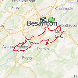
Randonnée V.T.T. de 29 km à découvrir à Bourgogne-Franche-Comté, Doubs, Besançon. Cette randonnée est proposée par tracegps.
Description
Ce parcours est très varié. On y retrouve du goudron, des singles, des pierres etc... Le début du parcours vous emmène par une petite route le long du Doubs sur les hauteurs du fort de Planoise. La descente de l'autre coté du fort est pentue et assez accidentée. En rejoignant le village d'Avanne, on traverse la route nationale et ici débute la montée au rocher de Valmy, puis la descente dans un petit sentier très agréable. Nous voici à Beure, sur la droite, une magnifique cascade se cache entre les branches des arbres. Entre sentiers et petites routes, nous arrivons au fort de Fontain, puis sur la crête, nous rejoignons le village de Morre. Dernière descente sur un single parsemé de traversées de cours d'eau. Retour au point de départ par les berges du Doubs.
Localisation
Commentaires
Randonnées à proximité
![Randonnée Marche Beure - Beure de la pisseur au mercureau - Photo](https://media.geolcdn.com/t/375/260/af87c349-0861-4e70-9a13-b157a632bd51.jpg&format=jpg&maxdim=2)
![Marche Marche](https://static1.geolcdn.com/sitytour/trail-icons/101.png)
Marche
![](/images/other/stat-length.png)
![](https://static1.geolcdn.com/siteimages/upload/files/16400158638029165_repeat_loop_refresh_sync_direction_icon.png)
![Randonnée Marche Beure -](https://media.geolcdn.com/t/375/260/1d465e36-f50c-4143-b089-4392e69daccf.jpg&format=jpg&maxdim=2)
![Marche Marche](https://static1.geolcdn.com/sitytour/trail-icons/101.png)
Marche
![](/images/other/stat-length.png)
![](https://static1.geolcdn.com/siteimages/upload/files/16400158638029165_repeat_loop_refresh_sync_direction_icon.png)
![Randonnée Marche Beure - Beure, fort Planoise, Valmy, Roche trouée, vieille église. - Photo](https://media.geolcdn.com/t/375/260/f17b22e5-5227-4f08-8b37-03856be840af.jpg&format=jpg&maxdim=2)
![Marche Marche](https://static1.geolcdn.com/sitytour/trail-icons/101.png)
Marche
![](/images/other/stat-length.png)
![](https://static1.geolcdn.com/siteimages/upload/files/16400158638029165_repeat_loop_refresh_sync_direction_icon.png)
![Randonnée Marche Montfaucon - Du chateau au fort de Monfaucon - Photo](https://media.geolcdn.com/t/375/260/ext.jpg?maxdim=2&url=https%3A%2F%2Fservices.sitytrail.com%2FGeolivesWS%2FDownloadMedia.ashx%3FTrailID%3D705744%26Media%3Dfix__20170226154846.jpg)
![Marche Marche](https://static1.geolcdn.com/sitytour/trail-icons/101.png)
Marche
![](/images/other/stat-length.png)
![](https://static1.geolcdn.com/siteimages/upload/files/16400158638029165_repeat_loop_refresh_sync_direction_icon.png)
![Randonnée Marche Besançon - Colline de Besançon 29-08-2020 - Photo](https://media.geolcdn.com/t/375/260/1e155548-d400-46d3-8b28-207c9933a379.jpg&format=jpg&maxdim=2)
![Marche Marche](https://static1.geolcdn.com/sitytour/trail-icons/101.png)
Marche
![](/images/other/stat-length.png)
![](https://static1.geolcdn.com/siteimages/upload/files/16400158638029165_repeat_loop_refresh_sync_direction_icon.png)
![Randonnée Marche Fontain - fontain - fort de Fontain - forêt de Fontain - Photo](https://media.geolcdn.com/t/375/260/dda8671d-de1b-4872-afba-e5376a2d57f0.jpg&format=jpg&maxdim=2)
![Marche Marche](https://static1.geolcdn.com/sitytour/trail-icons/101.png)
Marche
![](/images/other/stat-length.png)
![](https://static1.geolcdn.com/siteimages/upload/files/16400158638029165_repeat_loop_refresh_sync_direction_icon.png)
![Randonnée A pied Montfaucon - Boucle de Nacra - Photo](https://media.geolcdn.com/t/375/260/754b99f9-55b9-4375-839c-408b044dfd0e.jpeg&format=jpg&maxdim=2)
![A pied A pied](https://static1.geolcdn.com/sitytour/trail-icons/100.png)
A pied
![](/images/other/stat-length.png)
![](https://static1.geolcdn.com/siteimages/upload/files/16400158638029165_repeat_loop_refresh_sync_direction_icon.png)
![Randonnée A pied Montfaucon - Sentier des Falaises et du château - Photo](https://media.geolcdn.com/t/375/260/5325d98d-322b-4b71-b21b-224d670c2150.jpeg&format=jpg&maxdim=2)
![A pied A pied](https://static1.geolcdn.com/sitytour/trail-icons/100.png)
A pied
![](/images/other/stat-length.png)
![](https://static1.geolcdn.com/siteimages/upload/files/16400158638029165_repeat_loop_refresh_sync_direction_icon.png)
![Randonnée A pied Montfaucon - Sentier du Fort et des Batteries - Photo](https://media.geolcdn.com/t/375/260/465eae89-7ad3-4616-8710-419d54be2030.jpeg&format=jpg&maxdim=2)
![A pied A pied](https://static1.geolcdn.com/sitytour/trail-icons/100.png)
A pied
![](/images/other/stat-length.png)
![](https://static1.geolcdn.com/siteimages/upload/files/16400158638029165_repeat_loop_refresh_sync_direction_icon.png)