![](/images/other/stat-length.png)
![Randonnée Marche Lestelle-Bétharram - Lestelle - Boucle des Bastides - Photo](https://media.geolcdn.com/t/1900/400/ext.pjpeg?maxdim=2&url=https%3A%2F%2Fservices.sitytrail.com%2FGeolivesWS%2FDownloadMedia.ashx%3FTrailID%3D103322%26Media%3D5314_6.jpg)
Lestelle - Boucle des Bastides
tracegps
Utilisateur
![Longueur](/images/other/stat-length.png)
![Altitude max](https://static1.geolcdn.com/siteimages/upload/files/1508320355ic_sort_altitude_max_24dp.png)
![Dénivelé positif](https://static1.geolcdn.com/siteimages/upload/files/1508320355ic_sort_den_pos_24dp.png)
![Km-Effort](/images/other/stat-length.png)
![Altitude min](https://static1.geolcdn.com/siteimages/upload/files/1508320355ic_sort_altitude_min_24dp.png)
![Dénivelé négatif](https://static1.geolcdn.com/siteimages/upload/files/1508320355ic_sort_den_neg_24dp.png)
![Boucle](https://static1.geolcdn.com/siteimages/upload/files/16400158638029165_repeat_loop_refresh_sync_direction_icon.png)
![Marche](https://static1.geolcdn.com/sitytour/trail-icons/101.png)
3h00
Difficulté : Moyen
![Scannez ce code QR pour ouvrir la randonnée dans l'application SityTrail](https://capi.geolives.com/qq0zvz2zws4bq2lad0pu/sitytour/trails/103322/qr.png?size=200)
Application GPS de randonnée GRATUITE
À propos
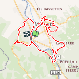
Randonnée Marche de 12,2 km à découvrir à Nouvelle-Aquitaine, Pyrénées-Atlantiques, Lestelle-Bétharram. Cette randonnée est proposée par tracegps.
Description
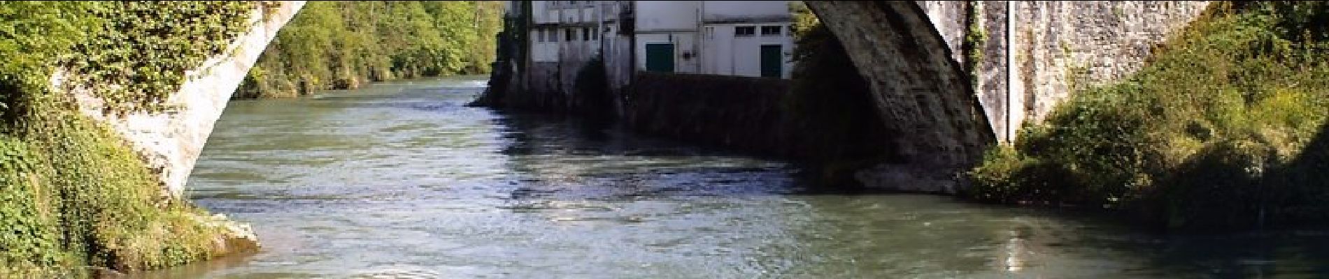
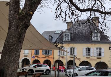
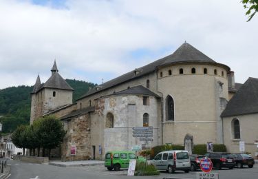
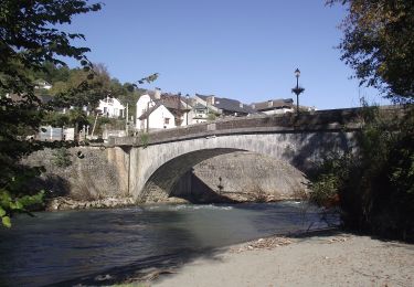
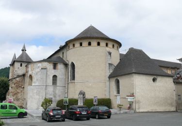
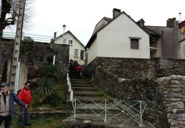
Beau parcours sans difficulté autour de Montaut et de Lestelle qui sont d'anciennes bastides. Le circuit longe d'abord le gave de Pau rive droite avant de passer sur les collines environnantes qui offrent de beaux paysages. A voir : le sanctuaire de Betharram, le pont des grottes et le slalom pour les kayakistes, la vue depuis la Croix des Hauteurs, les berges du gave au retour à Lestelle.
Localisation
Commentaires
Randonnées à proximité
![Randonnée Marche Lestelle-Bétharram - Lestelle les grottes G4 - Photo](https://media.geolcdn.com/t/375/260/7f7b50d2-f2bb-47c5-8f12-711bf0f3d7e6.jpg&format=jpg&maxdim=2)
![Marche Marche](https://static1.geolcdn.com/sitytour/trail-icons/101.png)
Marche
![](/images/other/stat-length.png)
![](https://static1.geolcdn.com/siteimages/upload/files/16400158638029165_repeat_loop_refresh_sync_direction_icon.png)
![Randonnée A pied Saint-Pé-de-Bigorre - SAINT PE DE BIGORRE Le grand tour de saint pe](https://media.geolcdn.com/t/375/260/d4e35e12-fcd4-45d8-ab2c-c6eef77cd69d.jpg&format=jpg&maxdim=2)
![A pied A pied](https://static1.geolcdn.com/sitytour/trail-icons/100.png)
A pied
![](/images/other/stat-length.png)
![](https://static1.geolcdn.com/siteimages/upload/files/16400158638029165_repeat_loop_refresh_sync_direction_icon.png)
![Randonnée A pied Saint-Pé-de-Bigorre - Le Plateau du Mousqué - Photo](https://media.geolcdn.com/t/375/260/42583d43-4f8c-4618-a872-ff80c3533f76.jpeg&format=jpg&maxdim=2)
![A pied A pied](https://static1.geolcdn.com/sitytour/trail-icons/100.png)
A pied
![](/images/other/stat-length.png)
![](https://static1.geolcdn.com/siteimages/upload/files/16400158638029165_repeat_loop_refresh_sync_direction_icon.png)
![Randonnée A pied Saint-Pé-de-Bigorre - Lengous et Montagnou - Photo](https://media.geolcdn.com/t/375/260/3d171576-7edb-45cf-8fd4-ef8c6e3c3bb3.jpeg&format=jpg&maxdim=2)
![A pied A pied](https://static1.geolcdn.com/sitytour/trail-icons/100.png)
A pied
![](/images/other/stat-length.png)
![](https://static1.geolcdn.com/siteimages/upload/files/16400158638029165_repeat_loop_refresh_sync_direction_icon.png)
![Randonnée A pied Saint-Pé-de-Bigorre - Les Coteaux de Saint-Pé - Photo](https://media.geolcdn.com/t/375/260/a489e4e4-1a5e-4103-b616-7e0cacda4ef5.jpeg&format=jpg&maxdim=2)
![A pied A pied](https://static1.geolcdn.com/sitytour/trail-icons/100.png)
A pied
![](/images/other/stat-length.png)
![](https://static1.geolcdn.com/siteimages/upload/files/16400158638029165_repeat_loop_refresh_sync_direction_icon.png)
![Randonnée Marche Saint-Pé-de-Bigorre - SAINT PE de BIGORRE et ses côteaux G4 faite avec LPC](https://media.geolcdn.com/t/375/260/80dcc544-2fa3-498d-9bdc-669b61c91573.jpg&format=jpg&maxdim=2)
![Marche Marche](https://static1.geolcdn.com/sitytour/trail-icons/101.png)
Marche
![](/images/other/stat-length.png)
![](https://static1.geolcdn.com/siteimages/upload/files/16400158638029165_repeat_loop_refresh_sync_direction_icon.png)
![Randonnée Marche Saint-Pé-de-Bigorre - Les Soums Saint-Péens - Saint Pé de Bigorre - Photo](https://media.geolcdn.com/t/375/260/ext.jpg?maxdim=2&url=https%3A%2F%2Fstatic1.geolcdn.com%2Fsiteimages%2Fupload%2Ffiles%2F1553511878bg_sport_marche.png)
![Marche Marche](https://static1.geolcdn.com/sitytour/trail-icons/101.png)
Marche
![](/images/other/stat-length.png)
![](https://static1.geolcdn.com/siteimages/upload/files/16400158638029165_repeat_loop_refresh_sync_direction_icon.png)
![Randonnée Marche Lestelle-Bétharram - 2023 10 10 CHEMIN du PIÉMONT PYRÉNÉEN - 18ème étape : Lestelle-Bétharram - Asson - Bruges - Mifaget - Ste Colome - Arudy - Photo](https://media.geolcdn.com/t/375/260/cf775eff-bc3f-4ffa-8e7c-bf58d3fbf382.jpg&format=jpg&maxdim=2)
![Marche Marche](https://static1.geolcdn.com/sitytour/trail-icons/101.png)
Marche
![](/images/other/stat-length.png)
![](https://static1.geolcdn.com/siteimages/upload/files/16400158638029165_repeat_loop_refresh_sync_direction_icon.png)
![Randonnée Marche Asson - ASSON Igon Touyas de Capsus](https://media.geolcdn.com/t/375/260/693cb2b3-525d-47a7-bda6-b1f6e19b3dcb.jpg&format=jpg&maxdim=2)
![Marche Marche](https://static1.geolcdn.com/sitytour/trail-icons/101.png)
Marche
![](/images/other/stat-length.png)
![](https://static1.geolcdn.com/siteimages/upload/files/16400158638029165_repeat_loop_refresh_sync_direction_icon.png)