![](/images/other/stat-length.png)
![Randonnée Marche Lignereuil - Lignereuil Allée des tilleuls - Blavincourt - Denier - Photo](https://media.geolcdn.com/t/1900/400/ext.pjpeg?maxdim=2&url=https%3A%2F%2Fstatic1.geolcdn.com%2Fsiteimages%2Fupload%2Ffiles%2F1553511878bg_sport_marche.png)
Lignereuil Allée des tilleuls - Blavincourt - Denier
tracegps
Utilisateur
![Longueur](/images/other/stat-length.png)
Longueur
11,2 km
![Altitude max](https://static1.geolcdn.com/siteimages/upload/files/1508320355ic_sort_altitude_max_24dp.png)
Altitude max
154 m
![Dénivelé positif](https://static1.geolcdn.com/siteimages/upload/files/1508320355ic_sort_den_pos_24dp.png)
Dénivelé positif
111 m
![Km-Effort](/images/other/stat-length.png)
Km-Effort
12,7 km
![Altitude min](https://static1.geolcdn.com/siteimages/upload/files/1508320355ic_sort_altitude_min_24dp.png)
Altitude min
110 m
![Dénivelé négatif](https://static1.geolcdn.com/siteimages/upload/files/1508320355ic_sort_den_neg_24dp.png)
Dénivelé négatif
113 m
![Boucle](https://static1.geolcdn.com/siteimages/upload/files/16400158638029165_repeat_loop_refresh_sync_direction_icon.png)
Boucle
Oui
Date de création :
2014-12-10 00:00:00.0
Dernière modification :
2014-12-10 00:00:00.0
![Marche](https://static1.geolcdn.com/sitytour/trail-icons/101.png)
2h00
Difficulté : Moyen
![Scannez ce code QR pour ouvrir la randonnée dans l'application SityTrail](https://capi.geolives.com/qq0zvz2zws4bq2lad0pu/sitytour/trails/103250/qr.png?size=200)
Application GPS de randonnée GRATUITE
À propos
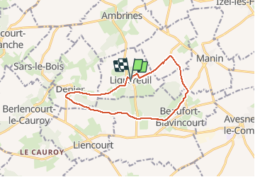
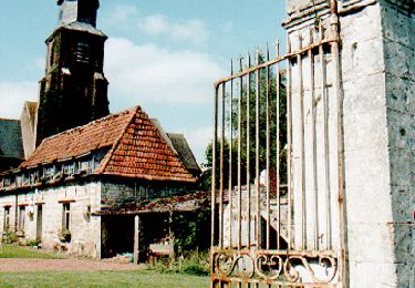
Randonnée Marche de 11,2 km à découvrir à Hauts-de-France, Pas-de-Calais, Lignereuil. Cette randonnée est proposée par tracegps.
Description
Randonnée du club Arras Inter Génération du 9 avril 2009. Très belle randonnée qui emprunte l'allée des tilleuls de Lignereuil à Gigenchy le Noble.
Localisation
Pays :
France
Région :
Hauts-de-France
Département/Province :
Pas-de-Calais
Commune :
Lignereuil
Localité :
Unknown
Départ:(Dec)
Départ:(UTM)
462462 ; 5570975 (31U) N.
Commentaires
Randonnées à proximité
![Randonnée V.T.T. Avesnes-le-Comte - Les 6 châteaux - Avesnes le Comte - Photo](https://media.geolcdn.com/t/375/260/ext.jpg?maxdim=2&url=https%3A%2F%2Fstatic1.geolcdn.com%2Fsiteimages%2Fupload%2Ffiles%2F1524743154velo.jpg)
![V.T.T. V.T.T.](https://static1.geolcdn.com/sitytour/trail-icons/202.png)
Les 6 châteaux - Avesnes le Comte
V.T.T.
Difficile
(1)
Avesnes-le-Comte,
Hauts-de-France,
Pas-de-Calais,
France
![](/images/other/stat-length.png)
44 km | 50 km-effort
2h 10min
![](https://static1.geolcdn.com/siteimages/upload/files/16400158638029165_repeat_loop_refresh_sync_direction_icon.png)
Oui
![Randonnée Marche Penin - Chemin des piedsentes (Penin) - Photo](https://media.geolcdn.com/t/375/260/ext.jpg?maxdim=2&url=https%3A%2F%2Fservices.sitytrail.com%2FGeolivesWS%2FDownloadMedia.ashx%3FTrailID%3D109845%26Media%3D4816_2.jpg)
![Marche Marche](https://static1.geolcdn.com/sitytour/trail-icons/101.png)
Chemin des piedsentes (Penin)
Marche
Difficile
Penin,
Hauts-de-France,
Pas-de-Calais,
France
![](/images/other/stat-length.png)
14,5 km | 15,7 km-effort
3h 40min
![](https://static1.geolcdn.com/siteimages/upload/files/16400158638029165_repeat_loop_refresh_sync_direction_icon.png)
Oui
![Randonnée Marche Berlencourt-le-Cauroy - Le sentier du loup (Berlencourt-le-cauroy) - Photo](https://media.geolcdn.com/t/375/260/ext.jpg?maxdim=2&url=https%3A%2F%2Fservices.sitytrail.com%2FGeolivesWS%2FDownloadMedia.ashx%3FTrailID%3D109827%26Media%3D4795_4.jpg)
![Marche Marche](https://static1.geolcdn.com/sitytour/trail-icons/101.png)
Le sentier du loup (Berlencourt-le-cauroy)
Marche
Difficile
Berlencourt-le-Cauroy,
Hauts-de-France,
Pas-de-Calais,
France
![](/images/other/stat-length.png)
15,2 km | 17,3 km-effort
3h 45min
![](https://static1.geolcdn.com/siteimages/upload/files/16400158638029165_repeat_loop_refresh_sync_direction_icon.png)
Oui
![Randonnée Marche Lignereuil - LIGNEREUIL (62) - Par le bois du Fay - Photo](https://media.geolcdn.com/t/375/260/ext.jpg?maxdim=2&url=https%3A%2F%2Fmedia.geolcdn.com%2Ff%2Fe01597ee-8b1e-43c0-8cff-a8ed0fa88de1.jpg)
![Marche Marche](https://static1.geolcdn.com/sitytour/trail-icons/101.png)
LIGNEREUIL (62) - Par le bois du Fay
Marche
Difficile
Lignereuil,
Hauts-de-France,
Pas-de-Calais,
France
![](/images/other/stat-length.png)
12,1 km | 13,5 km-effort
3h 4min
![](https://static1.geolcdn.com/siteimages/upload/files/16400158638029165_repeat_loop_refresh_sync_direction_icon.png)
Oui
![Randonnée Marche Avesnes-le-Comte - Avesnes le Comte, Noyelle-Vion, Manin, Beaufort-Blavincourt - Photo](https://media.geolcdn.com/t/375/260/ext.jpg?maxdim=2&url=https%3A%2F%2Fservices.sitytrail.com%2FGeolivesWS%2FDownloadMedia.ashx%3FTrailID%3D191466%26Media%3D15058_1.jpg)
![Marche Marche](https://static1.geolcdn.com/sitytour/trail-icons/101.png)
Avesnes le Comte, Noyelle-Vion, Manin, Beaufort-Blavincourt
Marche
Moyen
Avesnes-le-Comte,
Hauts-de-France,
Pas-de-Calais,
France
![](/images/other/stat-length.png)
10,8 km | 12,2 km-effort
2h 30min
![](https://static1.geolcdn.com/siteimages/upload/files/16400158638029165_repeat_loop_refresh_sync_direction_icon.png)
Oui
![Randonnée Marche Givenchy-le-Noble - Givenchy le Noble - Ambrines - Denier - Lignereuil - Photo](https://media.geolcdn.com/t/375/260/ext.jpg?maxdim=2&url=https%3A%2F%2Fservices.sitytrail.com%2FGeolivesWS%2FDownloadMedia.ashx%3FTrailID%3D104002%26Media%3D6942_2.jpg)
![Marche Marche](https://static1.geolcdn.com/sitytour/trail-icons/101.png)
Givenchy le Noble - Ambrines - Denier - Lignereuil
Marche
Moyen
Givenchy-le-Noble,
Hauts-de-France,
Pas-de-Calais,
France
![](/images/other/stat-length.png)
11 km | 12,5 km-effort
2h 0min
![](https://static1.geolcdn.com/siteimages/upload/files/16400158638029165_repeat_loop_refresh_sync_direction_icon.png)
Oui
![Randonnée V.T.T. Avesnes-le-Comte - Les six châteaux - Photo](https://media.geolcdn.com/t/375/260/ext.jpg?maxdim=2&url=https%3A%2F%2Fstatic1.geolcdn.com%2Fsiteimages%2Fupload%2Ffiles%2F1524743154velo.jpg)
![V.T.T. V.T.T.](https://static1.geolcdn.com/sitytour/trail-icons/202.png)
Les six châteaux
V.T.T.
Moyen
Avesnes-le-Comte,
Hauts-de-France,
Pas-de-Calais,
France
![](/images/other/stat-length.png)
44 km | 50 km-effort
Inconnu
![](https://static1.geolcdn.com/siteimages/upload/files/16400158638029165_repeat_loop_refresh_sync_direction_icon.png)
Oui
![Randonnée Marche Berlencourt-le-Cauroy - Berlencourt/Lucheux 23Kms Dén P 266m - Photo](https://media.geolcdn.com/t/375/260/ext.jpg?maxdim=2&url=https%3A%2F%2Fstatic1.geolcdn.com%2Fsiteimages%2Fupload%2Ffiles%2F1553511878bg_sport_marche.png)
![Marche Marche](https://static1.geolcdn.com/sitytour/trail-icons/101.png)
Berlencourt/Lucheux 23Kms Dén P 266m
Marche
Moyen
Berlencourt-le-Cauroy,
Hauts-de-France,
Pas-de-Calais,
France
![](/images/other/stat-length.png)
23 km | 27 km-effort
5h 49min
![](https://static1.geolcdn.com/siteimages/upload/files/16400158638029165_repeat_loop_refresh_sync_direction_icon.png)
Non
![Randonnée Marche Berlencourt-le-Cauroy - La Cauroy 11.3Kms Dén P 134m - Photo](https://media.geolcdn.com/t/375/260/ext.jpg?maxdim=2&url=https%3A%2F%2Fstatic1.geolcdn.com%2Fsiteimages%2Fupload%2Ffiles%2F1553511878bg_sport_marche.png)
![Marche Marche](https://static1.geolcdn.com/sitytour/trail-icons/101.png)
La Cauroy 11.3Kms Dén P 134m
Marche
Facile
Berlencourt-le-Cauroy,
Hauts-de-France,
Pas-de-Calais,
France
![](/images/other/stat-length.png)
11,5 km | 13,2 km-effort
2h 54min
![](https://static1.geolcdn.com/siteimages/upload/files/16400158638029165_repeat_loop_refresh_sync_direction_icon.png)
Oui