![](/images/other/stat-length.png)
![Randonnée Marche Saint-Félix-de-Villadeix - Saint Félix de Villadeix - Photo](https://media.geolcdn.com/t/1900/400/ext.pjpeg?maxdim=2&url=https%3A%2F%2Fstatic1.geolcdn.com%2Fsiteimages%2Fupload%2Ffiles%2F1553511878bg_sport_marche.png)
Saint Félix de Villadeix
tracegps
Utilisateur
![Longueur](/images/other/stat-length.png)
![Altitude max](https://static1.geolcdn.com/siteimages/upload/files/1508320355ic_sort_altitude_max_24dp.png)
![Dénivelé positif](https://static1.geolcdn.com/siteimages/upload/files/1508320355ic_sort_den_pos_24dp.png)
![Km-Effort](/images/other/stat-length.png)
![Altitude min](https://static1.geolcdn.com/siteimages/upload/files/1508320355ic_sort_altitude_min_24dp.png)
![Dénivelé négatif](https://static1.geolcdn.com/siteimages/upload/files/1508320355ic_sort_den_neg_24dp.png)
![Boucle](https://static1.geolcdn.com/siteimages/upload/files/16400158638029165_repeat_loop_refresh_sync_direction_icon.png)
![Marche](https://static1.geolcdn.com/sitytour/trail-icons/101.png)
3h07
Difficulté : Moyen
![Scannez ce code QR pour ouvrir la randonnée dans l'application SityTrail](https://capi.geolives.com/qq0zvz2zws4bq2lad0pu/sitytour/trails/103215/qr.png?size=200)
Application GPS de randonnée GRATUITE
À propos
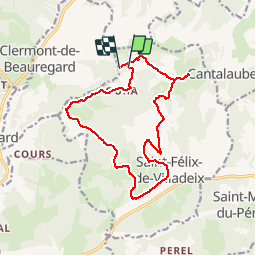
Randonnée Marche de 15,4 km à découvrir à Nouvelle-Aquitaine, Dordogne, Saint-Félix-de-Villadeix. Cette randonnée est proposée par tracegps.
Description
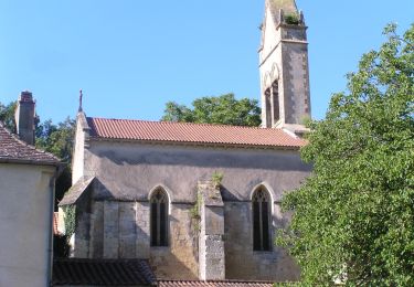
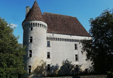
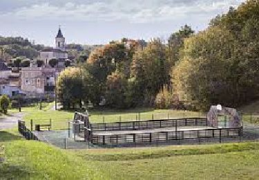
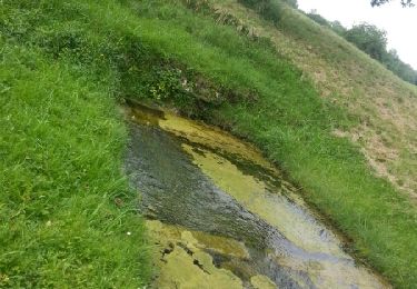
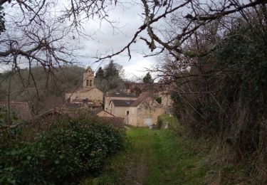
Balade autour de Saint Félix de Villadeix, un petit village situé à l’extrême nord du canton de Lalinde. Par le caractère de ses paysages et culture, c’est la fin du Périgord Pourpre et le début du Périgord Noir. On y accède en empruntant la route départementale N°32 qui part de Bergerac (18 Kms) en direction Nord-Est vers Ste Alvère (11 Kms). Autre possibilité, en prenant la RN 21 entre Périgueux et Bergerac. Situé sur la Louyre, sous affluent de la Dordogne, St Félix se partage entre bois et landes, d’une part et prés et culture d’autre part. D’une superficie de 1690 ha dont la moitié est occupée par une forêt périgourdine traditionnelle. La commune compte 293 habitants.(source Mairie de St Félix)
Localisation
Commentaires
Randonnées à proximité
![Randonnée A pied Saint-Marcel-du-Périgord - Tiregrand - Photo](https://media.geolcdn.com/t/375/260/d76ad4fb-69cd-4e5c-941f-cd26c9c0802e.jpeg&format=jpg&maxdim=2)
![A pied A pied](https://static1.geolcdn.com/sitytour/trail-icons/100.png)
A pied
![](/images/other/stat-length.png)
![](https://static1.geolcdn.com/siteimages/upload/files/16400158638029165_repeat_loop_refresh_sync_direction_icon.png)
![Randonnée A pied Saint-Georges-de-Montclard - Boucle de Saint-Georges-de-Monclard - Photo](https://media.geolcdn.com/t/375/260/807de1be-4d48-4c71-ad3a-97ab304f6622.jpeg&format=jpg&maxdim=2)
![A pied A pied](https://static1.geolcdn.com/sitytour/trail-icons/100.png)
A pied
![](/images/other/stat-length.png)
![](https://static1.geolcdn.com/siteimages/upload/files/16400158638029165_repeat_loop_refresh_sync_direction_icon.png)
![Randonnée Marche Clermont-de-Beauregard - Boucle de St Martin des Combes - Photo](https://media.geolcdn.com/t/375/260/ext.jpg?maxdim=2&url=https%3A%2F%2Fservices.sitytrail.com%2FGeolivesWS%2FDownloadMedia.ashx%3FTrailID%3D1118074%26Media%3Dfix__20190303122636.jpg)
![Marche Marche](https://static1.geolcdn.com/sitytour/trail-icons/101.png)
Marche
![](/images/other/stat-length.png)
![](https://static1.geolcdn.com/siteimages/upload/files/16400158638029165_repeat_loop_refresh_sync_direction_icon.png)
![Randonnée Marche Fouleix - Fouleix - Photo](https://media.geolcdn.com/t/375/260/aa8e9b84-78fe-4825-ba6c-0363c55c9dee.jpg&format=jpg&maxdim=2)
![Marche Marche](https://static1.geolcdn.com/sitytour/trail-icons/101.png)
Marche
![](/images/other/stat-length.png)
![](https://static1.geolcdn.com/siteimages/upload/files/16400158638029165_repeat_loop_refresh_sync_direction_icon.png)
![Randonnée Marche Fouleix - St Mayme de P. 20,2km - Photo](https://media.geolcdn.com/t/375/260/9e18d665-beb3-4bd8-afba-2d0a937195dd.jpg&format=jpg&maxdim=2)
![Marche Marche](https://static1.geolcdn.com/sitytour/trail-icons/101.png)
Marche
![](/images/other/stat-length.png)
![](https://static1.geolcdn.com/siteimages/upload/files/16400158638029165_repeat_loop_refresh_sync_direction_icon.png)
![Randonnée A pied Saint-Félix-de-Villadeix - La Peyrouse - Photo](https://media.geolcdn.com/t/375/260/9cb9bfb4-bb69-4fc5-bf21-b699d679142d.jpeg&format=jpg&maxdim=2)
![A pied A pied](https://static1.geolcdn.com/sitytour/trail-icons/100.png)
A pied
![](/images/other/stat-length.png)
![](https://static1.geolcdn.com/siteimages/upload/files/16400158638029165_repeat_loop_refresh_sync_direction_icon.png)
![Randonnée Marche Saint-Michel-de-Villadeix - Boucle des Vallons - Photo](https://media.geolcdn.com/t/375/260/03bd4373-9d33-4a6d-88e5-b397ee37a44d.jpg&format=jpg&maxdim=2)
![Marche Marche](https://static1.geolcdn.com/sitytour/trail-icons/101.png)
Marche
![](/images/other/stat-length.png)
![](https://static1.geolcdn.com/siteimages/upload/files/16400158638029165_repeat_loop_refresh_sync_direction_icon.png)
![Randonnée Marche Beauregard-et-Bassac - Boucle des Fontaines 11,7km - Photo](https://media.geolcdn.com/t/375/260/ext.jpg?maxdim=2&url=https%3A%2F%2Fservices.sitytrail.com%2FGeolivesWS%2FDownloadMedia.ashx%3FTrailID%3D987121%26Media%3Dfix__20180615182458.jpg)
![Marche Marche](https://static1.geolcdn.com/sitytour/trail-icons/101.png)
Marche
![](/images/other/stat-length.png)
![](https://static1.geolcdn.com/siteimages/upload/files/16400158638029165_repeat_loop_refresh_sync_direction_icon.png)
![Randonnée Marche Pressignac-Vicq - St Marcel du P. 13,1km - Photo](https://media.geolcdn.com/t/375/260/2e4edb75-a471-4285-bc24-e5ba0fde6119.jpg&format=jpg&maxdim=2)
![Marche Marche](https://static1.geolcdn.com/sitytour/trail-icons/101.png)
Marche
![](/images/other/stat-length.png)
![](https://static1.geolcdn.com/siteimages/upload/files/16400158638029165_repeat_loop_refresh_sync_direction_icon.png)