![](/images/other/stat-length.png)
![Randonnée V.T.T. Pezou - Rando Pezou 2009 - Photo](https://media.geolcdn.com/t/1900/400/ext.pjpeg?maxdim=2&url=https%3A%2F%2Fstatic1.geolcdn.com%2Fsiteimages%2Fupload%2Ffiles%2F1524743154velo.jpg)
Rando Pezou 2009
tracegps
Utilisateur
![Longueur](/images/other/stat-length.png)
Longueur
43 km
![Altitude max](https://static1.geolcdn.com/siteimages/upload/files/1508320355ic_sort_altitude_max_24dp.png)
Altitude max
151 m
![Dénivelé positif](https://static1.geolcdn.com/siteimages/upload/files/1508320355ic_sort_den_pos_24dp.png)
Dénivelé positif
583 m
![Km-Effort](/images/other/stat-length.png)
Km-Effort
50 km
![Altitude min](https://static1.geolcdn.com/siteimages/upload/files/1508320355ic_sort_altitude_min_24dp.png)
Altitude min
79 m
![Dénivelé négatif](https://static1.geolcdn.com/siteimages/upload/files/1508320355ic_sort_den_neg_24dp.png)
Dénivelé négatif
584 m
![Boucle](https://static1.geolcdn.com/siteimages/upload/files/16400158638029165_repeat_loop_refresh_sync_direction_icon.png)
Boucle
Oui
Date de création :
2014-12-10 00:00:00.0
Dernière modification :
2014-12-10 00:00:00.0
![V.T.T.](https://static1.geolcdn.com/sitytour/trail-icons/202.png)
2h45
Difficulté : Difficile
![Scannez ce code QR pour ouvrir la randonnée dans l'application SityTrail](https://capi.geolives.com/qq0zvz2zws4bq2lad0pu/sitytour/trails/103213/qr.png?size=200)
Application GPS de randonnée GRATUITE
À propos
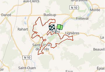
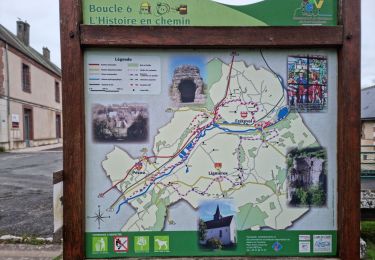
Randonnée V.T.T. de 43 km à découvrir à Centre-Val de Loire, Loir-et-Cher, Pezou. Cette randonnée est proposée par tracegps.
Description
Rando sur Pezou bien sympa, bonne montée par moment, de la route pour récupérer, du bois, pas trop de plaine et passage le long du Loir.
Localisation
Pays :
France
Région :
Centre-Val de Loire
Département/Province :
Loir-et-Cher
Commune :
Pezou
Localité :
Unknown
Départ:(Dec)
Départ:(UTM)
361295 ; 5302740 (31T) N.
Commentaires
Randonnées à proximité
![Randonnée Marche Fréteval - Fréteval - Champs Bois Grotte Étang - Photo](https://media.geolcdn.com/t/375/260/34045ca4-04f5-42e9-b8a9-99df3505cc2e.jpg&format=jpg&maxdim=2)
![Marche Marche](https://static1.geolcdn.com/sitytour/trail-icons/101.png)
Fréteval - Champs Bois Grotte Étang
Marche
Moyen
Fréteval,
Centre-Val de Loire,
Loir-et-Cher,
France
![](/images/other/stat-length.png)
11 km | 12,4 km-effort
2h 49min
![](https://static1.geolcdn.com/siteimages/upload/files/16400158638029165_repeat_loop_refresh_sync_direction_icon.png)
Oui
![Randonnée Marche La Chapelle-Enchérie - La Chapelle-Enchérie - Bois de Bricsard - Photo](https://media.geolcdn.com/t/375/260/0862f641-e319-4701-963f-83d27a100897.jpg&format=jpg&maxdim=2)
![Marche Marche](https://static1.geolcdn.com/sitytour/trail-icons/101.png)
La Chapelle-Enchérie - Bois de Bricsard
Marche
Facile
La Chapelle-Enchérie,
Centre-Val de Loire,
Loir-et-Cher,
France
![](/images/other/stat-length.png)
9,1 km | 10,9 km-effort
2h 20min
![](https://static1.geolcdn.com/siteimages/upload/files/16400158638029165_repeat_loop_refresh_sync_direction_icon.png)
Oui
![Randonnée Marche Lisle - Lisle - Bord du Loir - Photo](https://media.geolcdn.com/t/375/260/4f9116bd-eecc-48ec-adb9-fd3c5cad4087.jpg&format=jpg&maxdim=2)
![Marche Marche](https://static1.geolcdn.com/sitytour/trail-icons/101.png)
Lisle - Bord du Loir
Marche
Facile
Lisle,
Centre-Val de Loire,
Loir-et-Cher,
France
![](/images/other/stat-length.png)
8,9 km | 9,5 km-effort
2h 9min
![](https://static1.geolcdn.com/siteimages/upload/files/16400158638029165_repeat_loop_refresh_sync_direction_icon.png)
Oui
![Randonnée Marche Saint-Firmin-des-Prés - Saint-Firmin-des-Prés - Photo](https://media.geolcdn.com/t/375/260/a5813cc0-d151-48d6-b693-f67e132742f6.jpg&format=jpg&maxdim=2)
![Marche Marche](https://static1.geolcdn.com/sitytour/trail-icons/101.png)
Saint-Firmin-des-Prés
Marche
Facile
Saint-Firmin-des-Prés,
Centre-Val de Loire,
Loir-et-Cher,
France
![](/images/other/stat-length.png)
8,9 km | 9,9 km-effort
1h 58min
![](https://static1.geolcdn.com/siteimages/upload/files/16400158638029165_repeat_loop_refresh_sync_direction_icon.png)
Oui
![Randonnée Marche Fréteval - Fréteval - Etang Champs Bois Donjon - Photo](https://media.geolcdn.com/t/375/260/dbe14c3b-b458-4462-84f4-1045ca1ab83b.jpg&format=jpg&maxdim=2)
![Marche Marche](https://static1.geolcdn.com/sitytour/trail-icons/101.png)
Fréteval - Etang Champs Bois Donjon
Marche
Moyen
Fréteval,
Centre-Val de Loire,
Loir-et-Cher,
France
![](/images/other/stat-length.png)
10,8 km | 12,5 km-effort
2h 50min
![](https://static1.geolcdn.com/siteimages/upload/files/16400158638029165_repeat_loop_refresh_sync_direction_icon.png)
Oui
![Randonnée Marche Lisle - Lisle - Bois de l'Epau - Photo](https://media.geolcdn.com/t/375/260/f2ea5793-eafb-48f8-8f49-2ef6ceea9d28.jpg&format=jpg&maxdim=2)
![Marche Marche](https://static1.geolcdn.com/sitytour/trail-icons/101.png)
Lisle - Bois de l'Epau
Marche
Facile
Lisle,
Centre-Val de Loire,
Loir-et-Cher,
France
![](/images/other/stat-length.png)
8,9 km | 10,2 km-effort
2h 19min
![](https://static1.geolcdn.com/siteimages/upload/files/16400158638029165_repeat_loop_refresh_sync_direction_icon.png)
Oui
![Randonnée Marche Renay - Renay - Champs Bois Chapelle Eglise - Photo](https://media.geolcdn.com/t/375/260/ddc8d202-9993-403c-b2f2-d3983276bdc7.jpg&format=jpg&maxdim=2)
![Marche Marche](https://static1.geolcdn.com/sitytour/trail-icons/101.png)
Renay - Champs Bois Chapelle Eglise
Marche
Moyen
Renay,
Centre-Val de Loire,
Loir-et-Cher,
France
![](/images/other/stat-length.png)
13,8 km | 15,8 km-effort
3h 35min
![](https://static1.geolcdn.com/siteimages/upload/files/16400158638029165_repeat_loop_refresh_sync_direction_icon.png)
Oui
![Randonnée Marche Fréteval - Fréteval - L'histoire en chemin - Photo](https://media.geolcdn.com/t/375/260/dd7bbd73-a31b-4596-b9ef-a372bb9665f7.jpg&format=jpg&maxdim=2)
![Marche Marche](https://static1.geolcdn.com/sitytour/trail-icons/101.png)
Fréteval - L'histoire en chemin
Marche
Facile
Fréteval,
Centre-Val de Loire,
Loir-et-Cher,
France
![](/images/other/stat-length.png)
19,7 km | 22 km-effort
6h 25min
![](https://static1.geolcdn.com/siteimages/upload/files/16400158638029165_repeat_loop_refresh_sync_direction_icon.png)
Oui
![Randonnée Vélo Fréteval - Circuit des 2 coteaux - Fréteval - Photo](https://media.geolcdn.com/t/375/260/ext.jpg?maxdim=2&url=https%3A%2F%2Fservices.sitytrail.com%2FGeolivesWS%2FDownloadMedia.ashx%3FTrailID%3D112184%26Media%3D10045_6.jpg)
![Vélo Vélo](https://static1.geolcdn.com/sitytour/trail-icons/200.png)
Circuit des 2 coteaux - Fréteval
Vélo
Difficile
Fréteval,
Centre-Val de Loire,
Loir-et-Cher,
France
![](/images/other/stat-length.png)
48 km | 54 km-effort
3h 0min
![](https://static1.geolcdn.com/siteimages/upload/files/16400158638029165_repeat_loop_refresh_sync_direction_icon.png)
Oui