![](/images/other/stat-length.png)
![Randonnée Marche Orlu - En Beys Naguille - Photo](https://media.geolcdn.com/t/1900/400/ext.pjpeg?maxdim=2&url=https%3A%2F%2Fstatic1.geolcdn.com%2Fsiteimages%2Fupload%2Ffiles%2F1553511878bg_sport_marche.png)
En Beys Naguille
tracegps
Utilisateur
![Longueur](/images/other/stat-length.png)
![Altitude max](https://static1.geolcdn.com/siteimages/upload/files/1508320355ic_sort_altitude_max_24dp.png)
![Dénivelé positif](https://static1.geolcdn.com/siteimages/upload/files/1508320355ic_sort_den_pos_24dp.png)
![Km-Effort](/images/other/stat-length.png)
![Altitude min](https://static1.geolcdn.com/siteimages/upload/files/1508320355ic_sort_altitude_min_24dp.png)
![Dénivelé négatif](https://static1.geolcdn.com/siteimages/upload/files/1508320355ic_sort_den_neg_24dp.png)
![Boucle](https://static1.geolcdn.com/siteimages/upload/files/16400158638029165_repeat_loop_refresh_sync_direction_icon.png)
![Marche](https://static1.geolcdn.com/sitytour/trail-icons/101.png)
8h00
Difficulté : Difficile
![Scannez ce code QR pour ouvrir la randonnée dans l'application SityTrail](https://capi.geolives.com/qq0zvz2zws4bq2lad0pu/sitytour/trails/103152/qr.png?size=200)
Application GPS de randonnée GRATUITE
À propos
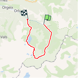
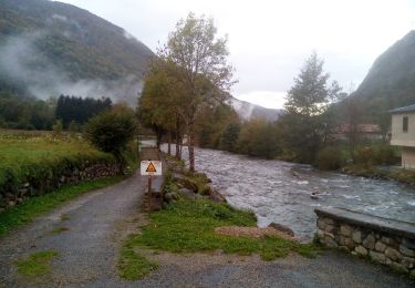
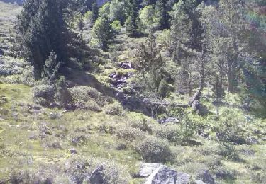
Randonnée Marche de 18,1 km à découvrir à Occitanie, Ariège, Orlu. Cette randonnée est proposée par tracegps.
Description
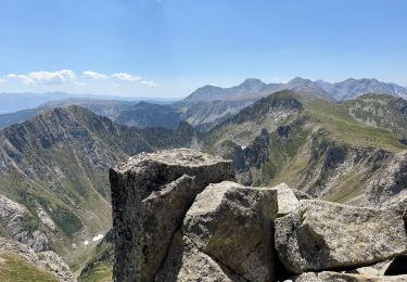
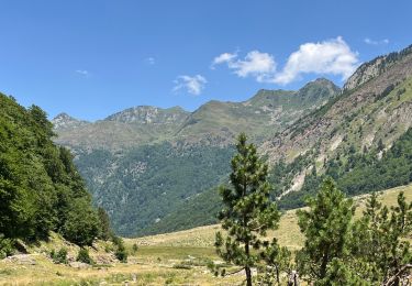
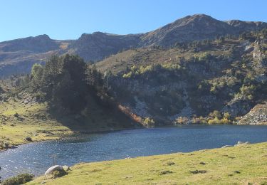
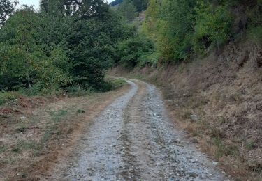
Départ du parking de Caralp, montée dans la réserve d'enBeys, passage par le refuge gardé d'En Beys puis la couillade d'en Beys, redescente par les lacs étangs des Peyrisses et grand lac de Naguille jusqu'au parking de la centrale. A ce parking reprendre la route pour remonter au parking de Caralp.
Localisation
Commentaires
Randonnées à proximité
![Randonnée Marche Orlu - Le Fanguil - Photo](https://media.geolcdn.com/t/375/260/c3accd76-1509-4827-a01c-0e33052ccaa5.jpg&format=jpg&maxdim=2)
![Marche Marche](https://static1.geolcdn.com/sitytour/trail-icons/101.png)
![Randonnée Marche Mijanès - Les 3 étangs de rabassoles - Photo](https://media.geolcdn.com/t/375/260/807f0f4c-4bca-4248-a54c-7fda09f527fc.jpg&format=jpg&maxdim=2)
![Marche Marche](https://static1.geolcdn.com/sitytour/trail-icons/101.png)
Marche
![](/images/other/stat-length.png)
![](https://static1.geolcdn.com/siteimages/upload/files/16400158638029165_repeat_loop_refresh_sync_direction_icon.png)
![Randonnée Marche Orlu - Le roc de la péra - Photo](https://media.geolcdn.com/t/375/260/73155c20-8e48-42b7-9201-111106b56065.jpg&format=jpg&maxdim=2)
![Marche Marche](https://static1.geolcdn.com/sitytour/trail-icons/101.png)
Marche
![](/images/other/stat-length.png)
![](https://static1.geolcdn.com/siteimages/upload/files/16400158638029165_repeat_loop_refresh_sync_direction_icon.png)
![Randonnée Marche Orlu - Vers le roc Blanc en partant du Fanguil puis les étangs de Baxouillade - Photo](https://media.geolcdn.com/t/375/260/039269ed-b0a9-4cb7-bbae-7a407c762425.jpg&format=jpg&maxdim=2)
![Marche Marche](https://static1.geolcdn.com/sitytour/trail-icons/101.png)
Marche
![](/images/other/stat-length.png)
![](https://static1.geolcdn.com/siteimages/upload/files/16400158638029165_repeat_loop_refresh_sync_direction_icon.png)
![Randonnée Marche Orlu - Orlu promenade des marmottes - Photo](https://media.geolcdn.com/t/375/260/5b2a5531-e3cc-44c5-8612-d73d9e8195ce.jpg&format=jpg&maxdim=2)
![Marche Marche](https://static1.geolcdn.com/sitytour/trail-icons/101.png)
Marche
![](/images/other/stat-length.png)
![](https://static1.geolcdn.com/siteimages/upload/files/16400158638029165_repeat_loop_refresh_sync_direction_icon.png)
![Randonnée Marche Mijanès - col de l'Egue par les etgs de Balbone et les Rebassoles (10.2021) - Photo](https://media.geolcdn.com/t/375/260/3801f39a-142a-4689-b05d-eaf1eb8d4416.jpg&format=jpg&maxdim=2)
![Marche Marche](https://static1.geolcdn.com/sitytour/trail-icons/101.png)
Marche
![](/images/other/stat-length.png)
![](https://static1.geolcdn.com/siteimages/upload/files/16400158638029165_repeat_loop_refresh_sync_direction_icon.png)
![Randonnée Marche nordique Orlu - Orlu, col de l'Osque, Porteille d'Orgeix, Orgeix - Photo](https://media.geolcdn.com/t/375/260/bb96309c-1ffe-4fdf-ba7a-51865c84fc15.jpg&format=jpg&maxdim=2)
![Marche nordique Marche nordique](https://static1.geolcdn.com/sitytour/trail-icons/102.png)
Marche nordique
![](/images/other/stat-length.png)
![](https://static1.geolcdn.com/siteimages/upload/files/16400158638029165_repeat_loop_refresh_sync_direction_icon.png)
![Randonnée Marche Orlu - LaLiau - Photo](https://media.geolcdn.com/t/375/260/a1553a6f-6a25-457e-a62d-a8e503e31d85.jpg&format=jpg&maxdim=2)
![Marche Marche](https://static1.geolcdn.com/sitytour/trail-icons/101.png)
![Randonnée Marche Mijanès - etangs rabassoles - Photo](https://media.geolcdn.com/t/375/260/ext.jpg?maxdim=2&url=https%3A%2F%2Fservices.sitytrail.com%2FGeolivesWS%2FDownloadMedia.ashx%3FTrailID%3D148387%26Media%3D20120807155919.jpeg)
![Marche Marche](https://static1.geolcdn.com/sitytour/trail-icons/101.png)
Marche
![](/images/other/stat-length.png)
![](https://static1.geolcdn.com/siteimages/upload/files/16400158638029165_repeat_loop_refresh_sync_direction_icon.png)