![](/images/other/stat-length.png)
![Randonnée Marche Hautecour - Crêt Coquet - Photo](https://media.geolcdn.com/t/1900/400/ext.pjpeg?maxdim=2&url=https%3A%2F%2Fstatic1.geolcdn.com%2Fsiteimages%2Fupload%2Ffiles%2F1553511878bg_sport_marche.png)
Crêt Coquet
tracegps
Utilisateur
![Longueur](/images/other/stat-length.png)
![Altitude max](https://static1.geolcdn.com/siteimages/upload/files/1508320355ic_sort_altitude_max_24dp.png)
![Dénivelé positif](https://static1.geolcdn.com/siteimages/upload/files/1508320355ic_sort_den_pos_24dp.png)
![Km-Effort](/images/other/stat-length.png)
![Altitude min](https://static1.geolcdn.com/siteimages/upload/files/1508320355ic_sort_altitude_min_24dp.png)
![Dénivelé négatif](https://static1.geolcdn.com/siteimages/upload/files/1508320355ic_sort_den_neg_24dp.png)
![Boucle](https://static1.geolcdn.com/siteimages/upload/files/16400158638029165_repeat_loop_refresh_sync_direction_icon.png)
![Marche](https://static1.geolcdn.com/sitytour/trail-icons/101.png)
3h30
Difficulté : Moyen
![Scannez ce code QR pour ouvrir la randonnée dans l'application SityTrail](https://capi.geolives.com/qq0zvz2zws4bq2lad0pu/sitytour/trails/103037/qr.png?size=200)
Application GPS de randonnée GRATUITE
À propos
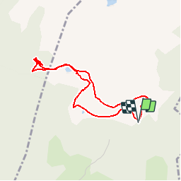
Randonnée Marche de 6,5 km à découvrir à Auvergne-Rhône-Alpes, Savoie, Hautecour. Cette randonnée est proposée par tracegps.
Description
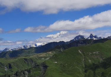
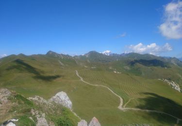
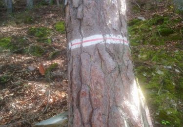
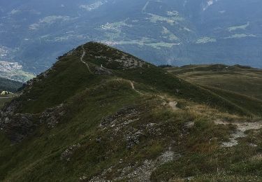
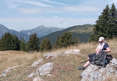
Accessible en été depuis le bout de la route, juste avant les chalets de la Faverge, mais aussi en hiver mais à partir de Pradier. Jolie balade avec une belle vue (au niveau du lac du Bouchet) sur les montagnes de La Plagne et des Arcs ainsi qu'en direction du Mont-Blanc. Le chalet de Crêt Coquet est très dépaysant mais la vue est plus dissimulée par les arbres.
Points d'intérêt
Localisation
Commentaires
Randonnées à proximité
![Randonnée Marche Hautecour - Le sentier artistique de Hautecour - Photo](https://media.geolcdn.com/t/375/260/ext.jpg?maxdim=2&url=https%3A%2F%2Fstatic1.geolcdn.com%2Fsiteimages%2Fupload%2Ffiles%2F1553511878bg_sport_marche.png)
![Marche Marche](https://static1.geolcdn.com/sitytour/trail-icons/101.png)
Marche
![](/images/other/stat-length.png)
![](https://static1.geolcdn.com/siteimages/upload/files/16400158638029165_repeat_loop_refresh_sync_direction_icon.png)
![Randonnée Marche La Léchère - Col des Génisses par le refuge du Nant du Beurre - Photo](https://media.geolcdn.com/t/375/260/c621086d-e802-4fc9-b77f-57f582faf42d.jpg&format=jpg&maxdim=2)
![Marche Marche](https://static1.geolcdn.com/sitytour/trail-icons/101.png)
Marche
![](/images/other/stat-length.png)
![](https://static1.geolcdn.com/siteimages/upload/files/16400158638029165_repeat_loop_refresh_sync_direction_icon.png)
![Randonnée Marche Aime-la-Plagne - croix de tessins roche de janatan - Photo](https://media.geolcdn.com/t/375/260/70bd5170-f1a0-4370-a8a9-2bd84b4c62f8.jpg&format=jpg&maxdim=2)
![Marche Marche](https://static1.geolcdn.com/sitytour/trail-icons/101.png)
Marche
![](/images/other/stat-length.png)
![](https://static1.geolcdn.com/siteimages/upload/files/16400158638029165_repeat_loop_refresh_sync_direction_icon.png)
![Randonnée Marche Grand-Aigueblanche - Cascade du Morel-20-07-22 - Photo](https://media.geolcdn.com/t/375/260/f72b1eaf-d1a3-4853-ba57-b26ebe92f90e.jpg&format=jpg&maxdim=2)
![Marche Marche](https://static1.geolcdn.com/sitytour/trail-icons/101.png)
Marche
![](/images/other/stat-length.png)
![](https://static1.geolcdn.com/siteimages/upload/files/16400158638029165_repeat_loop_refresh_sync_direction_icon.png)
![Randonnée Marche La Léchère - Tour du Quermoz par Grand Naves - Photo](https://media.geolcdn.com/t/375/260/b6009670-ce5c-4d7e-9ab7-0ee7a59863d7.jpg&format=jpg&maxdim=2)
![Marche Marche](https://static1.geolcdn.com/sitytour/trail-icons/101.png)
Marche
![](/images/other/stat-length.png)
![](https://static1.geolcdn.com/siteimages/upload/files/16400158638029165_repeat_loop_refresh_sync_direction_icon.png)
![Randonnée Marche La Léchère - Ronchat La Cudraz Navette Plan des Heures Balcon des Adrets de Tarentaise - Photo](https://media.geolcdn.com/t/375/260/31bbd3e5-7eb6-4ecd-afbb-fb24a4602b0f.jpg&format=jpg&maxdim=2)
![Marche Marche](https://static1.geolcdn.com/sitytour/trail-icons/101.png)
Marche
![](/images/other/stat-length.png)
![](https://static1.geolcdn.com/siteimages/upload/files/16400158638029165_repeat_loop_refresh_sync_direction_icon.png)
![Randonnée Marche Aime-la-Plagne - Circuit par les cretes Dzonfie, Quermoz depuis La Combe. - Photo](https://media.geolcdn.com/t/375/260/ext.jpg?maxdim=2&url=https%3A%2F%2Fservices.sitytrail.com%2FGeolivesWS%2FDownloadMedia.ashx%3FTrailID%3D629822%26Media%3D20160910133917.jpg)
![Marche Marche](https://static1.geolcdn.com/sitytour/trail-icons/101.png)
Marche
![](/images/other/stat-length.png)
![](https://static1.geolcdn.com/siteimages/upload/files/16400158638029165_repeat_loop_refresh_sync_direction_icon.png)
![Randonnée Raquettes à neige La Léchère - poinye du dzonfie - Photo](https://media.geolcdn.com/t/375/260/ext.jpg?maxdim=2&url=https%3A%2F%2Fservices.sitytrail.com%2FGeolivesWS%2FDownloadMedia.ashx%3FTrailID%3D175759%26Media%3D20130218114702.jpeg)
![Raquettes à neige Raquettes à neige](https://static1.geolcdn.com/sitytour/trail-icons/504.png)
Raquettes à neige
![](/images/other/stat-length.png)
![](https://static1.geolcdn.com/siteimages/upload/files/16400158638029165_repeat_loop_refresh_sync_direction_icon.png)
![Randonnée Marche La Léchère - grand naves Beaufortain - Photo](https://media.geolcdn.com/t/375/260/0d5c1464-9afe-40cd-a3c1-52f7950d0659.jpg&format=jpg&maxdim=2)
![Marche Marche](https://static1.geolcdn.com/sitytour/trail-icons/101.png)
Marche
![](/images/other/stat-length.png)
![](https://static1.geolcdn.com/siteimages/upload/files/16400158638029165_repeat_loop_refresh_sync_direction_icon.png)
Merci pour cette belle balade qui permet d'évoluer dans l'alpage sans qu'il y ait de sentier matérialisé. Très beau panorama depuis le Crêt Coquet et son refuge est sympa, par contre impossible de voir le Mont Blanc depuis ce lieu.
nyons 26