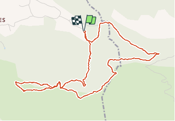
![](/images/other/stat-length.png)
![Randonnée Marche Simiane-Collongue - Pilon du Roy - Photo](https://media.geolcdn.com/t/1900/400/ext.pjpeg?maxdim=2&url=https%3A%2F%2Fstatic1.geolcdn.com%2Fsiteimages%2Fupload%2Ffiles%2F1553511878bg_sport_marche.png)
Pilon du Roy
tracegps
Utilisateur
![Longueur](/images/other/stat-length.png)
Longueur
6,7 km
![Altitude max](https://static1.geolcdn.com/siteimages/upload/files/1508320355ic_sort_altitude_max_24dp.png)
Altitude max
669 m
![Dénivelé positif](https://static1.geolcdn.com/siteimages/upload/files/1508320355ic_sort_den_pos_24dp.png)
Dénivelé positif
318 m
![Km-Effort](/images/other/stat-length.png)
Km-Effort
10,9 km
![Altitude min](https://static1.geolcdn.com/siteimages/upload/files/1508320355ic_sort_altitude_min_24dp.png)
Altitude min
402 m
![Dénivelé négatif](https://static1.geolcdn.com/siteimages/upload/files/1508320355ic_sort_den_neg_24dp.png)
Dénivelé négatif
318 m
![Boucle](https://static1.geolcdn.com/siteimages/upload/files/16400158638029165_repeat_loop_refresh_sync_direction_icon.png)
Boucle
Oui
Date de création :
2014-12-10 00:00:00.0
Dernière modification :
2014-12-10 00:00:00.0
![Marche](https://static1.geolcdn.com/sitytour/trail-icons/101.png)
3h00
Difficulté : Moyen
![Scannez ce code QR pour ouvrir la randonnée dans l'application SityTrail](https://capi.geolives.com/qq0zvz2zws4bq2lad0pu/sitytour/trails/103009/qr.png?size=200)
Application GPS de randonnée GRATUITE
À propos
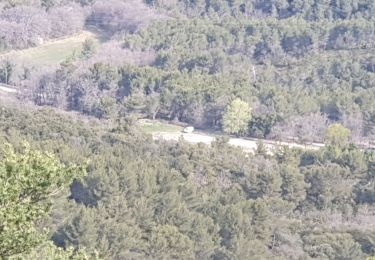
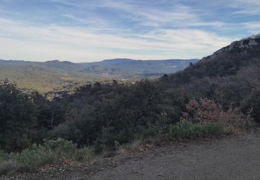
Randonnée Marche de 6,7 km à découvrir à Provence-Alpes-Côte d'Azur, Bouches-du-Rhône, Simiane-Collongue. Cette randonnée est proposée par tracegps.
Description
Vue magnifique sur Aix en Provence, Gardanne et sur Marseille. Par temps clair, on peut voir le mont Ventoux, et la chaine des Alpes...
Localisation
Pays :
France
Région :
Provence-Alpes-Côte d'Azur
Département/Province :
Bouches-du-Rhône
Commune :
Simiane-Collongue
Localité :
Unknown
Départ:(Dec)
Départ:(UTM)
700191 ; 4809642 (31T) N.
Commentaires
Randonnées à proximité
![Randonnée Marche Simiane-Collongue - chemin de gui - Photo](https://media.geolcdn.com/t/375/260/ext.jpg?maxdim=2&url=https%3A%2F%2Fservices.sitytrail.com%2FGeolivesWS%2FDownloadMedia.ashx%3FTrailID%3D902615%26Media%3D20180210121457.jpg)
![Marche Marche](https://static1.geolcdn.com/sitytour/trail-icons/101.png)
chemin de gui
Marche
Facile
(1)
Simiane-Collongue,
Provence-Alpes-Côte d'Azur,
Bouches-du-Rhône,
France
![](/images/other/stat-length.png)
5,9 km | 8,1 km-effort
1h 45min
![](https://static1.geolcdn.com/siteimages/upload/files/16400158638029165_repeat_loop_refresh_sync_direction_icon.png)
Oui
![Randonnée Course à pied Bouc-Bel-Air - Balade à Bouc Bel Air - Photo](https://media.geolcdn.com/t/375/260/ext.jpg?maxdim=2&url=https%3A%2F%2Fservices.sitytrail.com%2FGeolivesWS%2FDownloadMedia.ashx%3FTrailID%3D106593%26Media%3D11177_1.jpg)
![Course à pied Course à pied](https://static1.geolcdn.com/sitytour/trail-icons/103.png)
Balade à Bouc Bel Air
Course à pied
Moyen
(1)
Bouc-Bel-Air,
Provence-Alpes-Côte d'Azur,
Bouches-du-Rhône,
France
![](/images/other/stat-length.png)
6,6 km | 8,7 km-effort
34min
![](https://static1.geolcdn.com/siteimages/upload/files/16400158638029165_repeat_loop_refresh_sync_direction_icon.png)
Oui
![Randonnée Marche Allauch - N D des Anges massif de l'étoile - Photo](https://media.geolcdn.com/t/375/260/ext.jpg?maxdim=2&url=https%3A%2F%2Fmedia.geolcdn.com%2Ff%2F6a0032d7-e92c-4350-b286-01fec953b30e.jpg)
![Marche Marche](https://static1.geolcdn.com/sitytour/trail-icons/101.png)
N D des Anges massif de l'étoile
Marche
Moyen
Allauch,
Provence-Alpes-Côte d'Azur,
Bouches-du-Rhône,
France
![](/images/other/stat-length.png)
13,1 km | 19,5 km-effort
6h 51min
![](https://static1.geolcdn.com/siteimages/upload/files/16400158638029165_repeat_loop_refresh_sync_direction_icon.png)
Oui
![Randonnée Vélo électrique Simiane-Collongue - LES MARRES PILON DU ROI - Photo](https://media.geolcdn.com/t/375/260/ext.jpg?maxdim=2&url=https%3A%2F%2Fmedia.geolcdn.com%2Ff%2Fc4b78727-69dd-44a9-a9a1-4c1c067165d9.jpg)
![Vélo électrique Vélo électrique](https://static1.geolcdn.com/sitytour/trail-icons/205.png)
LES MARRES PILON DU ROI
Vélo électrique
Facile
Simiane-Collongue,
Provence-Alpes-Côte d'Azur,
Bouches-du-Rhône,
France
![](/images/other/stat-length.png)
26 km | 36 km-effort
2h 18min
![](https://static1.geolcdn.com/siteimages/upload/files/16400158638029165_repeat_loop_refresh_sync_direction_icon.png)
Oui
![Randonnée Marche Saint-Savournin - St Savourin Col Ste Anne - Photo](https://media.geolcdn.com/t/375/260/ext.jpg?maxdim=2&url=https%3A%2F%2Fmedia.geolcdn.com%2Ff%2Ff9c37524-8911-43ee-b603-d899fd2f39ae.jpg)
![Marche Marche](https://static1.geolcdn.com/sitytour/trail-icons/101.png)
St Savourin Col Ste Anne
Marche
Moyen
Saint-Savournin,
Provence-Alpes-Côte d'Azur,
Bouches-du-Rhône,
France
![](/images/other/stat-length.png)
9,2 km | 15,2 km-effort
2h 59min
![](https://static1.geolcdn.com/siteimages/upload/files/16400158638029165_repeat_loop_refresh_sync_direction_icon.png)
Oui
![Randonnée Marche Mimet - Massif de l'Etoile: Col Ste Anne, Pilon, Col des Ouides - Photo](https://media.geolcdn.com/t/375/260/ext.jpg?maxdim=2&url=https%3A%2F%2Fstatic1.geolcdn.com%2Fsiteimages%2Fupload%2Ffiles%2F1553511878bg_sport_marche.png)
![Marche Marche](https://static1.geolcdn.com/sitytour/trail-icons/101.png)
Massif de l'Etoile: Col Ste Anne, Pilon, Col des Ouides
Marche
Très difficile
(1)
Mimet,
Provence-Alpes-Côte d'Azur,
Bouches-du-Rhône,
France
![](/images/other/stat-length.png)
12,3 km | 19,4 km-effort
4h 49min
![](https://static1.geolcdn.com/siteimages/upload/files/16400158638029165_repeat_loop_refresh_sync_direction_icon.png)
Oui
![Randonnée Marche Mimet - le Baou traouca et la grotte des fées - Photo](https://media.geolcdn.com/t/375/260/ext.jpg?maxdim=2&url=https%3A%2F%2Fmedia.geolcdn.com%2Ff%2F2650f318-3cbd-4fde-bfd8-8343a2dcf579.jpg)
![Marche Marche](https://static1.geolcdn.com/sitytour/trail-icons/101.png)
le Baou traouca et la grotte des fées
Marche
Moyen
Mimet,
Provence-Alpes-Côte d'Azur,
Bouches-du-Rhône,
France
![](/images/other/stat-length.png)
11,2 km | 17,7 km-effort
5h 11min
![](https://static1.geolcdn.com/siteimages/upload/files/16400158638029165_repeat_loop_refresh_sync_direction_icon.png)
Oui
![Randonnée Marche Mimet - la chaîne de l'étoile au départ du col Sainte-Anne - Photo](https://media.geolcdn.com/t/375/260/ext.jpg?maxdim=2&url=https%3A%2F%2Fmedia.geolcdn.com%2Ff%2F424f934c-af97-4c20-a1dc-0385c23f9f2a.jpg)
![Marche Marche](https://static1.geolcdn.com/sitytour/trail-icons/101.png)
la chaîne de l'étoile au départ du col Sainte-Anne
Marche
Difficile
Mimet,
Provence-Alpes-Côte d'Azur,
Bouches-du-Rhône,
France
![](/images/other/stat-length.png)
16,2 km | 25 km-effort
5h 58min
![](https://static1.geolcdn.com/siteimages/upload/files/16400158638029165_repeat_loop_refresh_sync_direction_icon.png)
Oui
![Randonnée Marche Simiane-Collongue - PF-Simiane-Collongue - La Grande Etoile et le Petit Sanguin - ST - Photo](https://media.geolcdn.com/t/375/260/ext.jpg?maxdim=2&url=https%3A%2F%2Fmedia.geolcdn.com%2Ff%2F82a74cf5-866f-40df-bc18-cb0499817c37.jpg)
![Marche Marche](https://static1.geolcdn.com/sitytour/trail-icons/101.png)
PF-Simiane-Collongue - La Grande Etoile et le Petit Sanguin - ST
Marche
Très difficile
Simiane-Collongue,
Provence-Alpes-Côte d'Azur,
Bouches-du-Rhône,
France
![](/images/other/stat-length.png)
14,8 km | 21 km-effort
4h 23min
![](https://static1.geolcdn.com/siteimages/upload/files/16400158638029165_repeat_loop_refresh_sync_direction_icon.png)
Oui