![](/images/other/stat-length.png)
![Randonnée Marche Eyne - Le Cambre d'Ase - Photo](https://media.geolcdn.com/t/1900/400/ext.pjpeg?maxdim=2&url=https%3A%2F%2Fservices.sitytrail.com%2FGeolivesWS%2FDownloadMedia.ashx%3FTrailID%3D102891%26Media%3D4141_2.jpg)
Le Cambre d'Ase
tracegps
Utilisateur
![Longueur](/images/other/stat-length.png)
Longueur
8,9 km
![Altitude max](https://static1.geolcdn.com/siteimages/upload/files/1508320355ic_sort_altitude_max_24dp.png)
Altitude max
2730 m
![Dénivelé positif](https://static1.geolcdn.com/siteimages/upload/files/1508320355ic_sort_den_pos_24dp.png)
Dénivelé positif
955 m
![Km-Effort](/images/other/stat-length.png)
Km-Effort
22 km
![Altitude min](https://static1.geolcdn.com/siteimages/upload/files/1508320355ic_sort_altitude_min_24dp.png)
Altitude min
1794 m
![Dénivelé négatif](https://static1.geolcdn.com/siteimages/upload/files/1508320355ic_sort_den_neg_24dp.png)
Dénivelé négatif
951 m
![Boucle](https://static1.geolcdn.com/siteimages/upload/files/16400158638029165_repeat_loop_refresh_sync_direction_icon.png)
Boucle
Oui
Date de création :
2014-12-10 00:00:00.0
Dernière modification :
2014-12-10 00:00:00.0
![Marche](https://static1.geolcdn.com/sitytour/trail-icons/101.png)
4h00
Difficulté : Difficile
![Scannez ce code QR pour ouvrir la randonnée dans l'application SityTrail](https://capi.geolives.com/qq0zvz2zws4bq2lad0pu/sitytour/trails/102891/qr.png?size=200)
Application GPS de randonnée GRATUITE
À propos
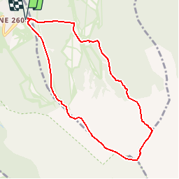
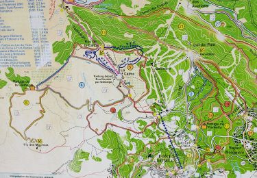
Randonnée Marche de 8,9 km à découvrir à Occitanie, Pyrénées-Orientales, Eyne. Cette randonnée est proposée par tracegps.
Description
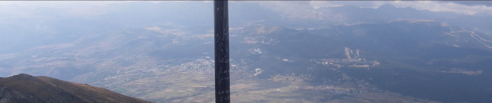
Belle randonnée qui domine Font Romeu et MontLouis. Départ raide sur les pistes de ski mais qui devient plus facile sur la deuxième partie. Vue sur l'Espagne au sommet.
Localisation
Pays :
France
Région :
Occitanie
Département/Province :
Pyrénées-Orientales
Commune :
Eyne
Localité :
Unknown
Départ:(Dec)
Départ:(UTM)
426349 ; 4703081 (31T) N.
Commentaires
Randonnées à proximité
![Randonnée Marche Eyne - Eyne,col de Nuria,pic d'Eyne,Torre d'Eyne,Eyne. - Photo](https://media.geolcdn.com/t/375/260/ext.jpg?maxdim=2&url=https%3A%2F%2Fservices.sitytrail.com%2FGeolivesWS%2FDownloadMedia.ashx%3FTrailID%3D530520%26Media%3D20150811115220.jpg)
![Marche Marche](https://static1.geolcdn.com/sitytour/trail-icons/101.png)
Eyne,col de Nuria,pic d'Eyne,Torre d'Eyne,Eyne.
Marche
Très difficile
(1)
Eyne,
Occitanie,
Pyrénées-Orientales,
France
![](/images/other/stat-length.png)
24 km | 43 km-effort
8h 44min
![](https://static1.geolcdn.com/siteimages/upload/files/16400158638029165_repeat_loop_refresh_sync_direction_icon.png)
Oui
![Randonnée Marche Planès - étang de Planès - Photo](https://media.geolcdn.com/t/375/260/ext.jpg?maxdim=2&url=https%3A%2F%2Fservices.sitytrail.com%2FGeolivesWS%2FDownloadMedia.ashx%3FTrailID%3D330882%26Media%3Dfix__20140804135744.jpg)
![Marche Marche](https://static1.geolcdn.com/sitytour/trail-icons/101.png)
étang de Planès
Marche
Moyen
(2)
Planès,
Occitanie,
Pyrénées-Orientales,
France
![](/images/other/stat-length.png)
10,8 km | 19,6 km-effort
3h 54min
![](https://static1.geolcdn.com/siteimages/upload/files/16400158638029165_repeat_loop_refresh_sync_direction_icon.png)
Non
![Randonnée Marche Eyne - Vallée d'Eyne - Photo](https://media.geolcdn.com/t/375/260/93dd56ed-3f9b-487e-93c8-7f2ec1ca29ff.jpg&format=jpg&maxdim=2)
![Marche Marche](https://static1.geolcdn.com/sitytour/trail-icons/101.png)
Vallée d'Eyne
Marche
Moyen
Eyne,
Occitanie,
Pyrénées-Orientales,
France
![](/images/other/stat-length.png)
10,7 km | 17,6 km-effort
4h 40min
![](https://static1.geolcdn.com/siteimages/upload/files/16400158638029165_repeat_loop_refresh_sync_direction_icon.png)
Oui
![Randonnée Marche Bolquère - bolqueres - Photo](https://media.geolcdn.com/t/375/260/0114987c-c8cc-4b45-b859-e4b1075b9834.jpg&format=jpg&maxdim=2)
![Marche Marche](https://static1.geolcdn.com/sitytour/trail-icons/101.png)
bolqueres
Marche
Très facile
(1)
Bolquère,
Occitanie,
Pyrénées-Orientales,
France
![](/images/other/stat-length.png)
3,8 km | 4,6 km-effort
1h 1min
![](https://static1.geolcdn.com/siteimages/upload/files/16400158638029165_repeat_loop_refresh_sync_direction_icon.png)
Oui
![Randonnée Marche La Cabanasse - Mois pontpedrouse après montée en train jaune - Photo](https://media.geolcdn.com/t/375/260/faab2c37-8bf8-419b-a8bb-43eea6c57cc7.jpg&format=jpg&maxdim=2)
![Marche Marche](https://static1.geolcdn.com/sitytour/trail-icons/101.png)
Mois pontpedrouse après montée en train jaune
Marche
Très facile
La Cabanasse,
Occitanie,
Pyrénées-Orientales,
France
![](/images/other/stat-length.png)
9,2 km | 14,3 km-effort
3h 33min
![](https://static1.geolcdn.com/siteimages/upload/files/16400158638029165_repeat_loop_refresh_sync_direction_icon.png)
Non
![Randonnée Marche Saint-Pierre-dels-Forcats - bains de St Thomas - Photo](https://media.geolcdn.com/t/375/260/ext.jpg?maxdim=2&url=https%3A%2F%2Fstatic1.geolcdn.com%2Fsiteimages%2Fupload%2Ffiles%2F1553511878bg_sport_marche.png)
![Marche Marche](https://static1.geolcdn.com/sitytour/trail-icons/101.png)
bains de St Thomas
Marche
Moyen
(1)
Saint-Pierre-dels-Forcats,
Occitanie,
Pyrénées-Orientales,
France
![](/images/other/stat-length.png)
8,6 km | 12,2 km-effort
2h 42min
![](https://static1.geolcdn.com/siteimages/upload/files/16400158638029165_repeat_loop_refresh_sync_direction_icon.png)
Non
![Randonnée Marche Eyne - eyne - Photo](https://media.geolcdn.com/t/375/260/ext.jpg?maxdim=2&url=https%3A%2F%2Fstatic1.geolcdn.com%2Fsiteimages%2Fupload%2Ffiles%2F1553511878bg_sport_marche.png)
![Marche Marche](https://static1.geolcdn.com/sitytour/trail-icons/101.png)
eyne
Marche
Moyen
(2)
Eyne,
Occitanie,
Pyrénées-Orientales,
France
![](/images/other/stat-length.png)
6,2 km | 8,2 km-effort
2h 1min
![](https://static1.geolcdn.com/siteimages/upload/files/16400158638029165_repeat_loop_refresh_sync_direction_icon.png)
Oui
![Randonnée Marche La Cabanasse - train jaune 01 - Photo](https://media.geolcdn.com/t/375/260/089f6d29-ecf8-4421-b837-b8b1a2c0c8be.jpg&format=jpg&maxdim=2)
![Marche Marche](https://static1.geolcdn.com/sitytour/trail-icons/101.png)
train jaune 01
Marche
Difficile
La Cabanasse,
Occitanie,
Pyrénées-Orientales,
France
![](/images/other/stat-length.png)
11,1 km | 15,1 km-effort
5h 3min
![](https://static1.geolcdn.com/siteimages/upload/files/16400158638029165_repeat_loop_refresh_sync_direction_icon.png)
Non
![Randonnée sport La Llagonne - La borde - Photo](https://media.geolcdn.com/t/375/260/d7b7e3d8-e8f3-4194-8414-fafc7f329da6.jpg&format=jpg&maxdim=2)
La borde
sport
Très facile
La Llagonne,
Occitanie,
Pyrénées-Orientales,
France
![](/images/other/stat-length.png)
7,3 km | 8,2 km-effort
Inconnu
![](https://static1.geolcdn.com/siteimages/upload/files/16400158638029165_repeat_loop_refresh_sync_direction_icon.png)
Non
excellente application !