![](/images/other/stat-length.png)
![Randonnée V.T.T. Aix-les-Bains - Randolac 2008 - Epine Chat Chambotte - Photo](https://media.geolcdn.com/t/1900/400/ext.pjpeg?maxdim=2&url=https%3A%2F%2Fservices.sitytrail.com%2FGeolivesWS%2FDownloadMedia.ashx%3FTrailID%3D102831%26Media%3D3994_2.jpg)
Randolac 2008 - Epine Chat Chambotte
tracegps
Utilisateur
![Longueur](/images/other/stat-length.png)
![Altitude max](https://static1.geolcdn.com/siteimages/upload/files/1508320355ic_sort_altitude_max_24dp.png)
![Dénivelé positif](https://static1.geolcdn.com/siteimages/upload/files/1508320355ic_sort_den_pos_24dp.png)
![Km-Effort](/images/other/stat-length.png)
![Altitude min](https://static1.geolcdn.com/siteimages/upload/files/1508320355ic_sort_altitude_min_24dp.png)
![Dénivelé négatif](https://static1.geolcdn.com/siteimages/upload/files/1508320355ic_sort_den_neg_24dp.png)
![Boucle](https://static1.geolcdn.com/siteimages/upload/files/16400158638029165_repeat_loop_refresh_sync_direction_icon.png)
![V.T.T.](https://static1.geolcdn.com/sitytour/trail-icons/202.png)
7h00
Difficulté : Très difficile
![Scannez ce code QR pour ouvrir la randonnée dans l'application SityTrail](https://capi.geolives.com/qq0zvz2zws4bq2lad0pu/sitytour/trails/102831/qr.png?size=200)
Application GPS de randonnée GRATUITE
À propos
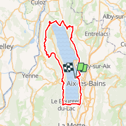
Randonnée V.T.T. de 64 km à découvrir à Auvergne-Rhône-Alpes, Savoie, Aix-les-Bains. Cette randonnée est proposée par tracegps.
Description
Circuit proposé par Alpes Tour Le départ se fait depuis la l'esplanade d'Aix-les-Bains. Ce parcours est un mini raid à lui tout seul. Pensez à prendre avec vous de quoi vous alimenter en eau et nourritures. Prenez aussi des pastilles de sel et des morceaux de sucre en cas de coup dur. Tous les conseils, recommandations indispensables de ce remarquable parcours sont ICI
Localisation
Commentaires
Randonnées à proximité
![Randonnée Marche Brison-Saint-Innocent - La Croix de Meyrieu, retour par la Grotte des Fées, depuis les Combes - Photo](https://media.geolcdn.com/t/375/260/ext.jpg?maxdim=2&url=https%3A%2F%2Fservices.sitytrail.com%2FGeolivesWS%2FDownloadMedia.ashx%3FTrailID%3D317495%26Media%3D16730_1.jpg)
![Marche Marche](https://static1.geolcdn.com/sitytour/trail-icons/101.png)
Marche
![](/images/other/stat-length.png)
![](https://static1.geolcdn.com/siteimages/upload/files/16400158638029165_repeat_loop_refresh_sync_direction_icon.png)
![Randonnée Marche Le Bourget-du-Lac - La Dent du Chat 1390m, le Molard Noir 1452m - Photo](https://media.geolcdn.com/t/375/260/ext.jpg?maxdim=2&url=https%3A%2F%2Fservices.sitytrail.com%2FGeolivesWS%2FDownloadMedia.ashx%3FTrailID%3D102504%26Media%3D3313_1.jpg)
![Marche Marche](https://static1.geolcdn.com/sitytour/trail-icons/101.png)
Marche
![](/images/other/stat-length.png)
![](https://static1.geolcdn.com/siteimages/upload/files/16400158638029165_repeat_loop_refresh_sync_direction_icon.png)
![Randonnée Marche Brison-Saint-Innocent - Grotte des fées, Croix de Meyrieu, Mont Corsuet 843m 1.7.24 - Photo](https://media.geolcdn.com/t/375/260/40c03b1e-7ecc-48c9-b0a4-5c8c250e48e1.jpg&format=jpg&maxdim=2)
![Marche Marche](https://static1.geolcdn.com/sitytour/trail-icons/101.png)
Marche
![](/images/other/stat-length.png)
![](https://static1.geolcdn.com/siteimages/upload/files/16400158638029165_repeat_loop_refresh_sync_direction_icon.png)
![Randonnée Marche Saint-Jean-de-Chevelu - st jean le chevelu - Photo](https://media.geolcdn.com/t/375/260/f752bdfc-b9bc-4dfb-b673-6eb9a7dfceae.jpg&format=jpg&maxdim=2)
![Marche Marche](https://static1.geolcdn.com/sitytour/trail-icons/101.png)
Marche
![](/images/other/stat-length.png)
![](https://static1.geolcdn.com/siteimages/upload/files/16400158638029165_repeat_loop_refresh_sync_direction_icon.png)
![Randonnée Vélo électrique Aix-les-Bains - Aix les bains tour lac de Bourget abbaye Hautecombes - Photo](https://media.geolcdn.com/t/375/260/6de4fae3-0815-4d48-bb94-d895cfa7b1bb.jpg&format=jpg&maxdim=2)
![Vélo électrique Vélo électrique](https://static1.geolcdn.com/sitytour/trail-icons/205.png)
Vélo électrique
![](/images/other/stat-length.png)
![](https://static1.geolcdn.com/siteimages/upload/files/16400158638029165_repeat_loop_refresh_sync_direction_icon.png)
![Randonnée Marche Saint-Jean-de-Chevelu - La dent du chat - Photo](https://media.geolcdn.com/t/375/260/ext.jpg?maxdim=2&url=https%3A%2F%2Fstatic1.geolcdn.com%2Fsiteimages%2Fupload%2Ffiles%2F1553511878bg_sport_marche.png)
![Marche Marche](https://static1.geolcdn.com/sitytour/trail-icons/101.png)
Marche
![](/images/other/stat-length.png)
![](https://static1.geolcdn.com/siteimages/upload/files/16400158638029165_repeat_loop_refresh_sync_direction_icon.png)
![Randonnée Via ferrata La Chapelle-du-Mont-du-Chat - 2011-04-03 via ferrata Col du chat - Photo](https://media.geolcdn.com/t/375/260/ext.jpg?maxdim=2&url=https%3A%2F%2Fstatic1.geolcdn.com%2Fsiteimages%2Fupload%2Ffiles%2F1545311037marcheuse_200dpi.jpg)
![Via ferrata Via ferrata](https://static1.geolcdn.com/sitytour/trail-icons/902.png)
Via ferrata
![](/images/other/stat-length.png)
![](https://static1.geolcdn.com/siteimages/upload/files/16400158638029165_repeat_loop_refresh_sync_direction_icon.png)
![Randonnée sport Aix-les-Bains - Colline du poète - Photo](https://media.geolcdn.com/t/375/260/52193566-3029-4655-87e0-73eaaebe11d3.jpg&format=jpg&maxdim=2)
sport
![](/images/other/stat-length.png)
![](https://static1.geolcdn.com/siteimages/upload/files/16400158638029165_repeat_loop_refresh_sync_direction_icon.png)
![Randonnée Marche Le Bourget-du-Lac - Dent du Chat, Mollard Noir, Refuge du Relais du Chat au départ du Sentier Botanique - Photo](https://media.geolcdn.com/t/375/260/89fa4c90-58f1-4891-bad5-9bd4924cd4f6.jpg&format=jpg&maxdim=2)
![Marche Marche](https://static1.geolcdn.com/sitytour/trail-icons/101.png)
Marche
![](/images/other/stat-length.png)
![](https://static1.geolcdn.com/siteimages/upload/files/16400158638029165_repeat_loop_refresh_sync_direction_icon.png)
Super