![](/images/other/stat-length.png)
![Randonnée V.T.T. Lacquy - De Lacquy à Pouydesseaux - Photo](https://media.geolcdn.com/t/1900/400/ext.pjpeg?maxdim=2&url=https%3A%2F%2Fservices.sitytrail.com%2FGeolivesWS%2FDownloadMedia.ashx%3FTrailID%3D102818%26Media%3D3978_1.jpg)
De Lacquy à Pouydesseaux
tracegps
Utilisateur
![Longueur](/images/other/stat-length.png)
Longueur
21 km
![Altitude max](https://static1.geolcdn.com/siteimages/upload/files/1508320355ic_sort_altitude_max_24dp.png)
Altitude max
137 m
![Dénivelé positif](https://static1.geolcdn.com/siteimages/upload/files/1508320355ic_sort_den_pos_24dp.png)
Dénivelé positif
187 m
![Km-Effort](/images/other/stat-length.png)
Km-Effort
24 km
![Altitude min](https://static1.geolcdn.com/siteimages/upload/files/1508320355ic_sort_altitude_min_24dp.png)
Altitude min
87 m
![Dénivelé négatif](https://static1.geolcdn.com/siteimages/upload/files/1508320355ic_sort_den_neg_24dp.png)
Dénivelé négatif
192 m
![Boucle](https://static1.geolcdn.com/siteimages/upload/files/16400158638029165_repeat_loop_refresh_sync_direction_icon.png)
Boucle
Oui
Date de création :
2014-12-10 00:00:00.0
Dernière modification :
2014-12-10 00:00:00.0
![V.T.T.](https://static1.geolcdn.com/sitytour/trail-icons/202.png)
2h00
Difficulté : Moyen
![Scannez ce code QR pour ouvrir la randonnée dans l'application SityTrail](https://capi.geolives.com/qq0zvz2zws4bq2lad0pu/sitytour/trails/102818/qr.png?size=200)
Application GPS de randonnée GRATUITE
À propos
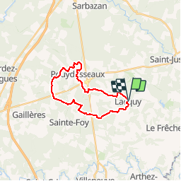
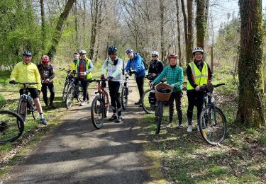
Randonnée V.T.T. de 21 km à découvrir à Nouvelle-Aquitaine, Landes, Lacquy. Cette randonnée est proposée par tracegps.
Description
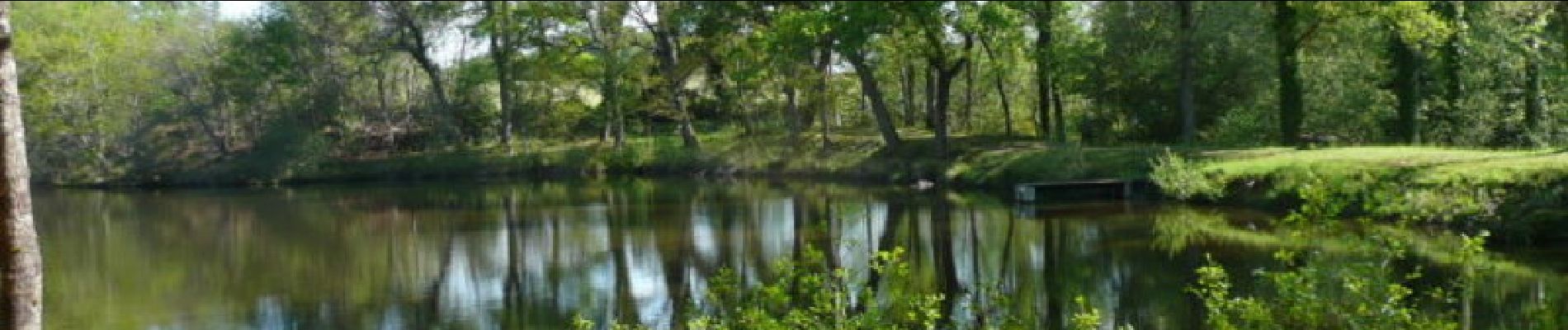
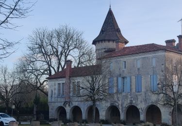
De Lacquy à Pouydesseaux. Intérêt : étangs, forêt, architecture traditionnelle landaise. Retrouvez d’autres photos et la description complète sur Ciron VTT, des circuits de randonnées VTT et traces GPS dans la vallée du Ciron (Gironde, Landes) et au-delà …
Localisation
Pays :
France
Région :
Nouvelle-Aquitaine
Département/Province :
Landes
Commune :
Lacquy
Localité :
Unknown
Départ:(Dec)
Départ:(UTM)
718690 ; 4870111 (30T) N.
Commentaires
Randonnées à proximité
![Randonnée V.T.C. Le Frêche - le freche Mont de Marsan - Photo](https://media.geolcdn.com/t/375/260/b1ca82d7-7be6-4db0-a13f-2bc75a5bb968.jpg&format=jpg&maxdim=2)
![V.T.C. V.T.C.](https://static1.geolcdn.com/sitytour/trail-icons/203.png)
le freche Mont de Marsan
V.T.C.
Facile
Le Frêche,
Nouvelle-Aquitaine,
Landes,
France
![](/images/other/stat-length.png)
50 km | 57 km-effort
3h 22min
![](https://static1.geolcdn.com/siteimages/upload/files/16400158638029165_repeat_loop_refresh_sync_direction_icon.png)
Oui
![Randonnée Marche Saint-Justin - Saint Justin boucle de l'église de Douzevieille - Photo](https://media.geolcdn.com/t/375/260/5db9b261-5962-497e-bf9d-aa57a6bbf44e.jpg&format=jpg&maxdim=2)
![Marche Marche](https://static1.geolcdn.com/sitytour/trail-icons/101.png)
Saint Justin boucle de l'église de Douzevieille
Marche
Très facile
(1)
Saint-Justin,
Nouvelle-Aquitaine,
Landes,
France
![](/images/other/stat-length.png)
10,1 km | 11,3 km-effort
2h 16min
![](https://static1.geolcdn.com/siteimages/upload/files/16400158638029165_repeat_loop_refresh_sync_direction_icon.png)
Oui
![Randonnée Marche Pouydesseaux - Pouydesseaux - Photo](https://media.geolcdn.com/t/375/260/ext.jpg?maxdim=2&url=https%3A%2F%2Fstatic1.geolcdn.com%2Fsiteimages%2Fupload%2Ffiles%2F1553511878bg_sport_marche.png)
![Marche Marche](https://static1.geolcdn.com/sitytour/trail-icons/101.png)
Pouydesseaux
Marche
Facile
Pouydesseaux,
Nouvelle-Aquitaine,
Landes,
France
![](/images/other/stat-length.png)
12,3 km | 13,6 km-effort
3h 0min
![](https://static1.geolcdn.com/siteimages/upload/files/16400158638029165_repeat_loop_refresh_sync_direction_icon.png)
Oui
![Randonnée Course à pied Pouydesseaux - CO étang mouliot - Photo](https://media.geolcdn.com/t/375/260/ext.jpg?maxdim=2&url=https%3A%2F%2Fstatic1.geolcdn.com%2Fsiteimages%2Fupload%2Ffiles%2F1524743154running.jpg)
![Course à pied Course à pied](https://static1.geolcdn.com/sitytour/trail-icons/103.png)
CO étang mouliot
Course à pied
Difficile
Pouydesseaux,
Nouvelle-Aquitaine,
Landes,
France
![](/images/other/stat-length.png)
9,7 km | 10,8 km-effort
3h 12min
![](https://static1.geolcdn.com/siteimages/upload/files/16400158638029165_repeat_loop_refresh_sync_direction_icon.png)
Oui
![Randonnée Marche Saint-Justin - boucle d Douzevielle 1 - Photo](https://media.geolcdn.com/t/375/260/ext.jpg?maxdim=2&url=https%3A%2F%2Fstatic1.geolcdn.com%2Fsiteimages%2Fupload%2Ffiles%2F1553511878bg_sport_marche.png)
![Marche Marche](https://static1.geolcdn.com/sitytour/trail-icons/101.png)
boucle d Douzevielle 1
Marche
Très facile
Saint-Justin,
Nouvelle-Aquitaine,
Landes,
France
![](/images/other/stat-length.png)
9,8 km | 11 km-effort
2h 35min
![](https://static1.geolcdn.com/siteimages/upload/files/16400158638029165_repeat_loop_refresh_sync_direction_icon.png)
Oui
![Randonnée Marche Saint-Justin - boucle de Douzevielle - Photo](https://media.geolcdn.com/t/375/260/ext.jpg?maxdim=2&url=https%3A%2F%2Fstatic1.geolcdn.com%2Fsiteimages%2Fupload%2Ffiles%2F1553511878bg_sport_marche.png)
![Marche Marche](https://static1.geolcdn.com/sitytour/trail-icons/101.png)
boucle de Douzevielle
Marche
Très facile
(1)
Saint-Justin,
Nouvelle-Aquitaine,
Landes,
France
![](/images/other/stat-length.png)
9,8 km | 11 km-effort
2h 21min
![](https://static1.geolcdn.com/siteimages/upload/files/16400158638029165_repeat_loop_refresh_sync_direction_icon.png)
Oui