![](/images/other/stat-length.png)
![Randonnée Marche La Hague - Ecalgrain et sa baie. - Photo](https://media.geolcdn.com/t/1900/400/ext.pjpeg?maxdim=2&url=https%3A%2F%2Fservices.sitytrail.com%2FGeolivesWS%2FDownloadMedia.ashx%3FTrailID%3D102758%26Media%3D3900_6.jpg)
Ecalgrain et sa baie.
tracegps
Utilisateur
![Longueur](/images/other/stat-length.png)
Longueur
13,4 km
![Altitude max](https://static1.geolcdn.com/siteimages/upload/files/1508320355ic_sort_altitude_max_24dp.png)
Altitude max
128 m
![Dénivelé positif](https://static1.geolcdn.com/siteimages/upload/files/1508320355ic_sort_den_pos_24dp.png)
Dénivelé positif
367 m
![Km-Effort](/images/other/stat-length.png)
Km-Effort
18,3 km
![Altitude min](https://static1.geolcdn.com/siteimages/upload/files/1508320355ic_sort_altitude_min_24dp.png)
Altitude min
8 m
![Dénivelé négatif](https://static1.geolcdn.com/siteimages/upload/files/1508320355ic_sort_den_neg_24dp.png)
Dénivelé négatif
370 m
![Boucle](https://static1.geolcdn.com/siteimages/upload/files/16400158638029165_repeat_loop_refresh_sync_direction_icon.png)
Boucle
Oui
Date de création :
2014-12-10 00:00:00.0
Dernière modification :
2014-12-10 00:00:00.0
![Marche](https://static1.geolcdn.com/sitytour/trail-icons/101.png)
3h15
Difficulté : Difficile
![Scannez ce code QR pour ouvrir la randonnée dans l'application SityTrail](https://capi.geolives.com/qq0zvz2zws4bq2lad0pu/sitytour/trails/102758/qr.png?size=200)
Application GPS de randonnée GRATUITE
À propos
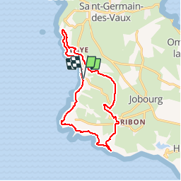
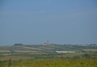
Randonnée Marche de 13,4 km à découvrir à Normandie, Manche, La Hague. Cette randonnée est proposée par tracegps.
Description
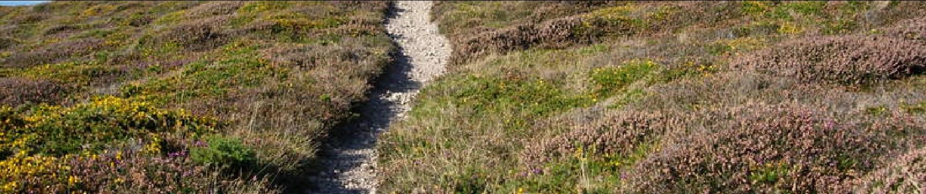
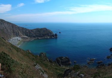
Départ et arrivée sur le parking de la baie d'Ecalgrain (circuit à déconseiller par grand vent). Vous serez émerveillés par ce circuit sur ces côtes encore sauvages et sa lande d'ajoncs et de bruyères. Voir le circuit FFRP n° 3519.
Localisation
Pays :
France
Région :
Normandie
Département/Province :
Manche
Commune :
La Hague
Localité :
Auderville
Départ:(Dec)
Départ:(UTM)
576842 ; 5504739 (30U) N.
Commentaires
Randonnées à proximité
![Randonnée Marche La Hague - NEZ JOBOURG - Photo](https://media.geolcdn.com/t/375/260/c98676c9-55e7-4381-9b91-05c742077aaf.jpg&format=jpg&maxdim=2)
![Marche Marche](https://static1.geolcdn.com/sitytour/trail-icons/101.png)
NEZ JOBOURG
Marche
Difficile
(2)
La Hague,
Normandie,
Manche,
France
![](/images/other/stat-length.png)
21 km | 27 km-effort
5h 48min
![](https://static1.geolcdn.com/siteimages/upload/files/16400158638029165_repeat_loop_refresh_sync_direction_icon.png)
Oui
![Randonnée V.T.T. La Hague - Le Tour des Echoués - Jobourg - Photo](https://media.geolcdn.com/t/375/260/ext.jpg?maxdim=2&url=https%3A%2F%2Fservices.sitytrail.com%2FGeolivesWS%2FDownloadMedia.ashx%3FTrailID%3D173186%26Media%3D14770_5.jpg)
![V.T.T. V.T.T.](https://static1.geolcdn.com/sitytour/trail-icons/202.png)
Le Tour des Echoués - Jobourg
V.T.T.
Moyen
(1)
La Hague,
Normandie,
Manche,
France
![](/images/other/stat-length.png)
26 km | 32 km-effort
2h 0min
![](https://static1.geolcdn.com/siteimages/upload/files/16400158638029165_repeat_loop_refresh_sync_direction_icon.png)
Oui
![Randonnée A pied La Hague - Séjour Cotentin Etape 3 Nez de Jobourg - Biville - Photo](https://media.geolcdn.com/t/375/260/0edaec19-e94e-4149-8092-0ff358c3dd07.jpg&format=jpg&maxdim=2)
![A pied A pied](https://static1.geolcdn.com/sitytour/trail-icons/100.png)
Séjour Cotentin Etape 3 Nez de Jobourg - Biville
A pied
Difficile
La Hague,
Normandie,
Manche,
France
![](/images/other/stat-length.png)
23 km | 33 km-effort
7h 30min
![](https://static1.geolcdn.com/siteimages/upload/files/16400158638029165_repeat_loop_refresh_sync_direction_icon.png)
Non
![Randonnée Marche La Hague - Séjour Cotentin Etape 3 Le nez de Jobourg et Biville a corriger - Photo](https://media.geolcdn.com/t/375/260/769074c5-2128-40cd-af27-847ab7c0e7c4.jpg&format=jpg&maxdim=2)
![Marche Marche](https://static1.geolcdn.com/sitytour/trail-icons/101.png)
Séjour Cotentin Etape 3 Le nez de Jobourg et Biville a corriger
Marche
Très difficile
La Hague,
Normandie,
Manche,
France
![](/images/other/stat-length.png)
23 km | 33 km-effort
7h 31min
![](https://static1.geolcdn.com/siteimages/upload/files/16400158638029165_repeat_loop_refresh_sync_direction_icon.png)
Non
![Randonnée A pied La Hague - Séjour Cotentin Etape 2 Boucle Jobourg La Hague - Port Racine - Omonville la petite - Photo](https://media.geolcdn.com/t/375/260/c0e0de9e-3bd4-4319-af5c-c6b5aff35ffd.jpg&format=jpg&maxdim=2)
![A pied A pied](https://static1.geolcdn.com/sitytour/trail-icons/100.png)
Séjour Cotentin Etape 2 Boucle Jobourg La Hague - Port Racine - Omonville la ...
A pied
Difficile
La Hague,
Normandie,
Manche,
France
![](/images/other/stat-length.png)
28 km | 34 km-effort
7h 44min
![](https://static1.geolcdn.com/siteimages/upload/files/16400158638029165_repeat_loop_refresh_sync_direction_icon.png)
Oui
![Randonnée Marche La Hague - goury / vauville - Photo](https://media.geolcdn.com/t/375/260/ext.jpg?maxdim=2&url=https%3A%2F%2Fstatic1.geolcdn.com%2Fsiteimages%2Fupload%2Ffiles%2F1553511878bg_sport_marche.png)
![Marche Marche](https://static1.geolcdn.com/sitytour/trail-icons/101.png)
goury / vauville
Marche
Difficile
(1)
La Hague,
Normandie,
Manche,
France
![](/images/other/stat-length.png)
16,5 km | 24 km-effort
5h 17min
![](https://static1.geolcdn.com/siteimages/upload/files/16400158638029165_repeat_loop_refresh_sync_direction_icon.png)
Non
![Randonnée Marche La Hague - Magiquement votre - Photo](https://media.geolcdn.com/t/375/260/c49fffc8-7c79-42cf-a4d6-b3c2cf7eec90.jpg&format=jpg&maxdim=2)
![Marche Marche](https://static1.geolcdn.com/sitytour/trail-icons/101.png)
Magiquement votre
Marche
Moyen
La Hague,
Normandie,
Manche,
France
![](/images/other/stat-length.png)
25 km | 33 km-effort
6h 12min
![](https://static1.geolcdn.com/siteimages/upload/files/16400158638029165_repeat_loop_refresh_sync_direction_icon.png)
Oui
![Randonnée Marche La Hague - Boucle St-Germain-des-Vaux - Auderville - La Roche - Goury - Photo](https://media.geolcdn.com/t/375/260/e5808f0a-2966-4fdc-bdca-55912ac6256a.jpg&format=jpg&maxdim=2)
![Marche Marche](https://static1.geolcdn.com/sitytour/trail-icons/101.png)
Boucle St-Germain-des-Vaux - Auderville - La Roche - Goury
Marche
Facile
La Hague,
Normandie,
Manche,
France
![](/images/other/stat-length.png)
12,4 km | 14,7 km-effort
5h 22min
![](https://static1.geolcdn.com/siteimages/upload/files/16400158638029165_repeat_loop_refresh_sync_direction_icon.png)
Oui
![Randonnée A pied La Hague - Le sentier du contrebandier - Photo](https://media.geolcdn.com/t/375/260/20887ba1-a1d2-4ea6-8734-c9a0180555a0.jpeg&format=jpg&maxdim=2)
![A pied A pied](https://static1.geolcdn.com/sitytour/trail-icons/100.png)
Le sentier du contrebandier
A pied
Facile
La Hague,
Normandie,
Manche,
France
![](/images/other/stat-length.png)
10,8 km | 15,3 km-effort
3h 28min
![](https://static1.geolcdn.com/siteimages/upload/files/16400158638029165_repeat_loop_refresh_sync_direction_icon.png)
Oui