![](/images/other/stat-length.png)
![Randonnée V.T.T. Roz-sur-Couesnon - Espace VTT FFC de la Baie du Mont St-Michel - 06 - Circuit panoramique - Photo](https://media.geolcdn.com/t/1900/400/ext.pjpeg?maxdim=2&url=https%3A%2F%2Fservices.sitytrail.com%2FGeolivesWS%2FDownloadMedia.ashx%3FTrailID%3D102733%26Media%3D3865_1.jpg)
Espace VTT FFC de la Baie du Mont St-Michel - 06 - Circuit panoramique
tracegps
Utilisateur
![Longueur](/images/other/stat-length.png)
![Altitude max](https://static1.geolcdn.com/siteimages/upload/files/1508320355ic_sort_altitude_max_24dp.png)
![Dénivelé positif](https://static1.geolcdn.com/siteimages/upload/files/1508320355ic_sort_den_pos_24dp.png)
![Km-Effort](/images/other/stat-length.png)
![Altitude min](https://static1.geolcdn.com/siteimages/upload/files/1508320355ic_sort_altitude_min_24dp.png)
![Dénivelé négatif](https://static1.geolcdn.com/siteimages/upload/files/1508320355ic_sort_den_neg_24dp.png)
![Boucle](https://static1.geolcdn.com/siteimages/upload/files/16400158638029165_repeat_loop_refresh_sync_direction_icon.png)
![V.T.T.](https://static1.geolcdn.com/sitytour/trail-icons/202.png)
2h30
Difficulté : Difficile
![Scannez ce code QR pour ouvrir la randonnée dans l'application SityTrail](https://capi.geolives.com/qq0zvz2zws4bq2lad0pu/sitytour/trails/102733/qr.png?size=200)
Application GPS de randonnée GRATUITE
À propos
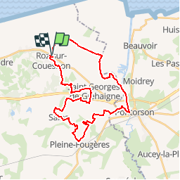
Randonnée V.T.T. de 33 km à découvrir à Bretagne, Ille-et-Vilaine, Roz-sur-Couesnon. Cette randonnée est proposée par tracegps.
Description
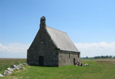
Espace VTT FFC de la Baie du Mont Saint-Michel Circuit labellisé par la Fédération Française de Cyclisme. Espace VTT FFC de la Baie du Mont St-Michel - 06 - Circuit panoramique Traverser les polders et leurs champs géométriques, couper en direction du Mont-Saint-Michel, escalader le balcon et découvrir la baie des premières hauteurs, emprunter les chemins creux entre les étangs, visiter la forêt de Villecartier, contourner le marais de Sougéal, et rencontrer les châteaux au milieu du bocage : autant de curiosités que vous offre ce site.
Localisation
Commentaires
Randonnées à proximité
![Randonnée A pied Saint-Georges-de-Gréhaigne - Circuit du Petit Bois & de la Grève - Photo](https://media.geolcdn.com/t/375/260/5902253f-7208-4ff1-b384-45fcc25c7a03.jpeg&format=jpg&maxdim=2)
![A pied A pied](https://static1.geolcdn.com/sitytour/trail-icons/100.png)
A pied
![](/images/other/stat-length.png)
![](https://static1.geolcdn.com/siteimages/upload/files/16400158638029165_repeat_loop_refresh_sync_direction_icon.png)
![Randonnée A pied Saint-Georges-de-Gréhaigne - Découverte des polders - Photo](https://media.geolcdn.com/t/375/260/1947c4ab-7a2f-4caa-9962-ed302558c2aa.jpeg&format=jpg&maxdim=2)
![A pied A pied](https://static1.geolcdn.com/sitytour/trail-icons/100.png)
A pied
![](/images/other/stat-length.png)
![](https://static1.geolcdn.com/siteimages/upload/files/16400158638029165_repeat_loop_refresh_sync_direction_icon.png)
![Randonnée A pied Saint-Broladre - Les deux vallées - Photo](https://media.geolcdn.com/t/375/260/f63071ef-4d51-4abc-a46c-a9d73085527b.jpeg&format=jpg&maxdim=2)
![A pied A pied](https://static1.geolcdn.com/sitytour/trail-icons/100.png)
A pied
![](/images/other/stat-length.png)
![](https://static1.geolcdn.com/siteimages/upload/files/16400158638029165_repeat_loop_refresh_sync_direction_icon.png)
![Randonnée A pied Saint-Marcan - Le télégraphe de Chappe - Photo](https://media.geolcdn.com/t/375/260/f63071ef-4d51-4abc-a46c-a9d73085527b.jpeg&format=jpg&maxdim=2)
![A pied A pied](https://static1.geolcdn.com/sitytour/trail-icons/100.png)
A pied
![](/images/other/stat-length.png)
![](https://static1.geolcdn.com/siteimages/upload/files/16400158638029165_repeat_loop_refresh_sync_direction_icon.png)
![Randonnée A pied Roz-sur-Couesnon - Les Polders - Photo](https://media.geolcdn.com/t/375/260/49a70907-bf3e-4690-a5ed-5ebe1f5addc4.jpeg&format=jpg&maxdim=2)
![A pied A pied](https://static1.geolcdn.com/sitytour/trail-icons/100.png)
A pied
![](/images/other/stat-length.png)
![](https://static1.geolcdn.com/siteimages/upload/files/16400158638029165_repeat_loop_refresh_sync_direction_icon.png)
![Randonnée A pied Roz-sur-Couesnon - Les Belvédères du Mont-Saint-Michel - Photo](https://media.geolcdn.com/t/375/260/49a70907-bf3e-4690-a5ed-5ebe1f5addc4.jpeg&format=jpg&maxdim=2)
![A pied A pied](https://static1.geolcdn.com/sitytour/trail-icons/100.png)
A pied
![](/images/other/stat-length.png)
![](https://static1.geolcdn.com/siteimages/upload/files/16400158638029165_repeat_loop_refresh_sync_direction_icon.png)
![Randonnée Marche Saint-Marcan - GR_34_AB_02_St-Marcan_Hirel_20230319 - Photo](https://media.geolcdn.com/t/375/260/9aaab890-2c82-469d-a309-c40a7479a6de.jpg&format=jpg&maxdim=2)
![Marche Marche](https://static1.geolcdn.com/sitytour/trail-icons/101.png)
Marche
![](/images/other/stat-length.png)
![](https://static1.geolcdn.com/siteimages/upload/files/16400158638029165_repeat_loop_refresh_sync_direction_icon.png)
![Randonnée Cheval Saint-Broladre - Voie Verte de la Baie du Mont-Saint-Michel - Photo](https://media.geolcdn.com/t/375/260/ext.jpg?maxdim=2&url=https%3A%2F%2Fservices.sitytrail.com%2FGeolivesWS%2FDownloadMedia.ashx%3FTrailID%3D317262%26Media%3D16446_5.jpg)
![Cheval Cheval](https://static1.geolcdn.com/sitytour/trail-icons/300.png)
Cheval
![](/images/other/stat-length.png)
![](https://static1.geolcdn.com/siteimages/upload/files/16400158638029165_repeat_loop_refresh_sync_direction_icon.png)
![Randonnée Cheval Roz-sur-Couesnon - Le Balcon de la Baie - Roz-sur-Couesnon - Photo](https://media.geolcdn.com/t/375/260/ext.jpg?maxdim=2&url=https%3A%2F%2Fservices.sitytrail.com%2FGeolivesWS%2FDownloadMedia.ashx%3FTrailID%3D317257%26Media%3D16442_5.jpg)
![Cheval Cheval](https://static1.geolcdn.com/sitytour/trail-icons/300.png)
Cheval
![](/images/other/stat-length.png)
![](https://static1.geolcdn.com/siteimages/upload/files/16400158638029165_repeat_loop_refresh_sync_direction_icon.png)