![](/images/other/stat-length.png)
![Randonnée V.T.T. Champagney - Champagney Ballastières - Photo](https://media.geolcdn.com/t/1900/400/ext.pjpeg?maxdim=2&url=https%3A%2F%2Fstatic1.geolcdn.com%2Fsiteimages%2Fupload%2Ffiles%2F1524743154velo.jpg)
Champagney Ballastières
tracegps
Utilisateur
![Longueur](/images/other/stat-length.png)
![Altitude max](https://static1.geolcdn.com/siteimages/upload/files/1508320355ic_sort_altitude_max_24dp.png)
![Dénivelé positif](https://static1.geolcdn.com/siteimages/upload/files/1508320355ic_sort_den_pos_24dp.png)
![Km-Effort](/images/other/stat-length.png)
![Altitude min](https://static1.geolcdn.com/siteimages/upload/files/1508320355ic_sort_altitude_min_24dp.png)
![Dénivelé négatif](https://static1.geolcdn.com/siteimages/upload/files/1508320355ic_sort_den_neg_24dp.png)
![Boucle](https://static1.geolcdn.com/siteimages/upload/files/16400158638029165_repeat_loop_refresh_sync_direction_icon.png)
![V.T.T.](https://static1.geolcdn.com/sitytour/trail-icons/202.png)
3h15
Difficulté : Difficile
![Scannez ce code QR pour ouvrir la randonnée dans l'application SityTrail](https://capi.geolives.com/qq0zvz2zws4bq2lad0pu/sitytour/trails/102720/qr.png?size=200)
Application GPS de randonnée GRATUITE
À propos
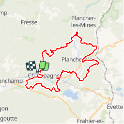
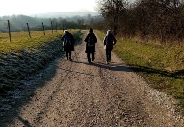
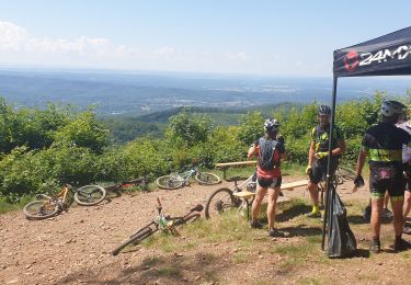
Randonnée V.T.T. de 37 km à découvrir à Bourgogne-Franche-Comté, Haute-Saône, Champagney. Cette randonnée est proposée par tracegps.
Description
Le départ se fait depuis les Ballastières de Champagney, et démarre tranquillement par du plat, sur une piste en herbe qui longe la route. Très vite, après la traversée de la route , on s'engage dans de jolis sentiers , avec qq racines. Vous longerez le parcours "Vita", faites un sourire aux jogueuses... peu après , qq maisons, quartier du Magny . La vous êtes chaud, ça tombe bien, les choses sérieuses vont commencer. Une belle et petite montée , et vous allez continuer ainsi, à travers le "Pays Sous Vosgien". Allez, bonne balade, pensez à prendre qq nourriture et boisson , surtout!!
Localisation
Commentaires
Randonnées à proximité
![Randonnée Marche Ronchamp - le tour par la chapelle Ronchamp - Photo](https://media.geolcdn.com/t/375/260/ext.jpg?maxdim=2&url=https%3A%2F%2Fservices.sitytrail.com%2FGeolivesWS%2FDownloadMedia.ashx%3FTrailID%3D200144%26Media%3D20130623170833.jpeg)
![Marche Marche](https://static1.geolcdn.com/sitytour/trail-icons/101.png)
Marche
![](/images/other/stat-length.png)
![](https://static1.geolcdn.com/siteimages/upload/files/16400158638029165_repeat_loop_refresh_sync_direction_icon.png)
![Randonnée Marche Ronchamp - Ronchamp - Chapelle ND du Haut - sentier de l'Etançon (puits de mines) - Photo](https://media.geolcdn.com/t/375/260/17f2d8a4-0385-46eb-a4ac-833c4b43d439.jpg&format=jpg&maxdim=2)
![Marche Marche](https://static1.geolcdn.com/sitytour/trail-icons/101.png)
Marche
![](/images/other/stat-length.png)
![](https://static1.geolcdn.com/siteimages/upload/files/16400158638029165_repeat_loop_refresh_sync_direction_icon.png)
![Randonnée Marche Champagney - Canal souterrain de la Haute-Saône - Photo](https://media.geolcdn.com/t/375/260/04c8dd3d-861a-49bc-aa06-88e783162bdc.jpg&format=jpg&maxdim=2)
![Marche Marche](https://static1.geolcdn.com/sitytour/trail-icons/101.png)
Marche
![](/images/other/stat-length.png)
![](https://static1.geolcdn.com/siteimages/upload/files/16400158638029165_repeat_loop_refresh_sync_direction_icon.png)
![Randonnée Marche Frahier-et-Chatebier - frahier - Photo](https://media.geolcdn.com/t/375/260/95f0d94d-e209-4293-8856-d410c2620589.jpg&format=jpg&maxdim=2)
![Marche Marche](https://static1.geolcdn.com/sitytour/trail-icons/101.png)
Marche
![](/images/other/stat-length.png)
![](https://static1.geolcdn.com/siteimages/upload/files/16400158638029165_repeat_loop_refresh_sync_direction_icon.png)
![Randonnée Marche Champagney - Champagney - canal de la Haute-Saône - tunnel - Photo](https://media.geolcdn.com/t/375/260/53752e24-7a78-44c3-b746-8236e26bab64.jpg&format=jpg&maxdim=2)
![Marche Marche](https://static1.geolcdn.com/sitytour/trail-icons/101.png)
Marche
![](/images/other/stat-length.png)
![](https://static1.geolcdn.com/siteimages/upload/files/16400158638029165_repeat_loop_refresh_sync_direction_icon.png)
![Randonnée Marche Champagney - Grotte prisonniers allemands - château Etobon - Etobon - Photo](https://media.geolcdn.com/t/375/260/f76125a8-85be-43f8-b3b5-d887afc7fd40.jpg&format=jpg&maxdim=2)
![Marche Marche](https://static1.geolcdn.com/sitytour/trail-icons/101.png)
Marche
![](/images/other/stat-length.png)
![](https://static1.geolcdn.com/siteimages/upload/files/16400158638029165_repeat_loop_refresh_sync_direction_icon.png)
![Randonnée Marche Champagney - parcours sportif des Épaisses à Champagney - Photo](https://media.geolcdn.com/t/375/260/5ea0a359-1d7e-46eb-81bb-44044f5bf7c9.jpg&format=jpg&maxdim=2)
![Marche Marche](https://static1.geolcdn.com/sitytour/trail-icons/101.png)
Marche
![](/images/other/stat-length.png)
![](https://static1.geolcdn.com/siteimages/upload/files/16400158638029165_repeat_loop_refresh_sync_direction_icon.png)
![Randonnée V.T.T. Ronchamp - rando VTT club lure, ronchamp la filature, le plainet - Photo](https://media.geolcdn.com/t/375/260/74582360-9399-4bb9-bd36-d524b524a244.jpg&format=jpg&maxdim=2)
![V.T.T. V.T.T.](https://static1.geolcdn.com/sitytour/trail-icons/202.png)
V.T.T.
![](/images/other/stat-length.png)
![](https://static1.geolcdn.com/siteimages/upload/files/16400158638029165_repeat_loop_refresh_sync_direction_icon.png)
![Randonnée V.T.T. Ronchamp - Filature de ronchamp, bassin de champagney - Photo](https://media.geolcdn.com/t/375/260/0fb0814e-f221-4c85-810a-089a0332e1ac.jpg&format=jpg&maxdim=2)
![V.T.T. V.T.T.](https://static1.geolcdn.com/sitytour/trail-icons/202.png)
V.T.T.
![](/images/other/stat-length.png)
![](https://static1.geolcdn.com/siteimages/upload/files/16400158638029165_repeat_loop_refresh_sync_direction_icon.png)