Randonnée Marche Linxe - Linxe 9.85 - Photo

Pignada nous voilà

© OpenStreetMap contributors
Longueur
Longueur
9,8 km
Altitude max
Altitude max
53 m
Dénivelé positif
Dénivelé positif
126 m
Km-Effort
Km-Effort  
11,5 km
Altitude min
Altitude min
13 m
Dénivelé négatif
Dénivelé négatif
127 m
Boucle
Boucle
Oui
Date de création :
2019-01-15 15:03:47.503
Dernière modification :
2020-09-17 16:51:55.235

(0 Avis)

Marche
Marche
2h00
Difficulté : Facile

Scannez ce code QR pour ouvrir la randonnée dans l'application SityTrail

Application GPS de randonnée GRATUITE

Logo SityTrail SityTrail

IGN / Instituts géographiques

Télécharger SityTrail sur l'App Store Télécharger SityTrail sur Google Play

Logo SityTrail SityTrail World

Le monde est à vous

Télécharger SityTrail sur l'App Store Télécharger SityTrail sur Google Play Télécharger SityTrail sur Huawei AppGallery

À propos

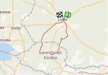
Randonnée Marche de 9,8 km à découvrir à Nouvelle-Aquitaine, Landes, Linxe. Cette randonnée est proposée par les randonneurs rionnais.

Profil altimétrique

Localisation

Pays :
France
Région :
Nouvelle-Aquitaine
Département/Province :
Landes
Commune :
Linxe
Localité :
Unknown
Départ:(UTM)
640783 ; 4864485 (30T) N.

Randonnées à proximité

Randonnée Vélo de route Vielle-Saint-Girons - Vielle Huchet Moliets - Photo
Vélo de route
philbea31

Vélo de route

Facile
Vielle-Saint-Girons, Nouvelle-Aquitaine, Landes, France
35 km | 41 km-effort
2h 21min
Oui
Randonnée Marche Linxe - marche gourmande 2024 - Photo
Marche
rionnais40

Marche

Moyen
Linxe, Nouvelle-Aquitaine, Landes, France
8,4 km | 10 km-effort
2h 14min
Oui
Randonnée Marche Vielle-Saint-Girons - jour 8 du 02/07/23 - Photo
Marche
Céline Charbonnieras

Marche

Très difficile
Vielle-Saint-Girons, Nouvelle-Aquitaine, Landes, France
17,1 km | 19,2 km-effort
4h 46min
Non
Randonnée V.T.C. Vielle-Saint-Girons - boucle St Girons 2 - Photo
V.T.C.
Sébastien Jeandidier

V.T.C.

Moyen
Vielle-Saint-Girons, Nouvelle-Aquitaine, Landes, France
22 km | 26 km-effort
1h 11min
Oui
Randonnée Marche Vielle-Saint-Girons - courant d'huchet, du camping de Vielle au pas du loup et retour par le pignada - 7.8 - Photo
Marche

Marche

Moyen
Vielle-Saint-Girons, Nouvelle-Aquitaine, Landes, France
7,8 km | 9,6 km-effort
1h 45min
Oui
Randonnée Marche Vielle-Saint-Girons - courant d'huchet, du camping de Vielle au pas du loup et retour par le pignada - 9.8 - Photo
Marche

Marche

Moyen
Vielle-Saint-Girons, Nouvelle-Aquitaine, Landes, France
9,8 km | 11,4 km-effort
2h 0min
Oui
Randonnée Marche Vielle-Saint-Girons - Comp 23 Étape 9 Saint Girons Vieux Boucau  - Photo
Marche
gwenola63

Marche

Difficile
Vielle-Saint-Girons, Nouvelle-Aquitaine, Landes, France
27 km | 31 km-effort
7h 0min
Non
Randonnée Marche Vielle-Saint-Girons - Vielle St-Girons à Moliets par le courant d'Huchet - 16 - Photo
Marche
hartmannpat

Marche

Difficile
Vielle-Saint-Girons, Nouvelle-Aquitaine, Landes, France
15,8 km | 17,8 km-effort
4h 3min
Non
Randonnée V.T.C. Vielle-Saint-Girons - boucle St Girons - Photo
V.T.C.
Sébastien Jeandidier

V.T.C.

Moyen
Vielle-Saint-Girons, Nouvelle-Aquitaine, Landes, France
21 km | 25 km-effort
1h 14min
Oui


Fermer
Mes abonnements