![](/images/other/stat-length.png)
![Randonnée Marche Saint-Mury-Monteymond - La Pointe de la Sitre - 2195m - Photo](https://media.geolcdn.com/t/1900/400/ext.pjpeg?maxdim=2&url=https%3A%2F%2Fservices.sitytrail.com%2FGeolivesWS%2FDownloadMedia.ashx%3FTrailID%3D102675%26Media%3D3690_1.jpg)
La Pointe de la Sitre - 2195m
tracegps
Utilisateur
![Longueur](/images/other/stat-length.png)
![Altitude max](https://static1.geolcdn.com/siteimages/upload/files/1508320355ic_sort_altitude_max_24dp.png)
![Dénivelé positif](https://static1.geolcdn.com/siteimages/upload/files/1508320355ic_sort_den_pos_24dp.png)
![Km-Effort](/images/other/stat-length.png)
![Altitude min](https://static1.geolcdn.com/siteimages/upload/files/1508320355ic_sort_altitude_min_24dp.png)
![Dénivelé négatif](https://static1.geolcdn.com/siteimages/upload/files/1508320355ic_sort_den_neg_24dp.png)
![Boucle](https://static1.geolcdn.com/siteimages/upload/files/16400158638029165_repeat_loop_refresh_sync_direction_icon.png)
![Marche](https://static1.geolcdn.com/sitytour/trail-icons/101.png)
5h00
Difficulté : Moyen
![Scannez ce code QR pour ouvrir la randonnée dans l'application SityTrail](https://capi.geolives.com/qq0zvz2zws4bq2lad0pu/sitytour/trails/102675/qr.png?size=200)
Application GPS de randonnée GRATUITE
À propos
Randonnée Marche de 9,6 km à découvrir à Auvergne-Rhône-Alpes, Isère, Saint-Mury-Monteymond. Cette randonnée est proposée par tracegps.
Description
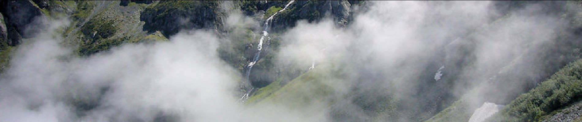
La Pointe de la Sitre, 2195m Le sommet herbeux, sorte d'antécime au Nord Ouest de la Grande Lance de Domène, permet de dessiner un circuit intéressant qui ne présente pas de grandes difficultés. Depuis, un lacet de la route forestière de Pré Long, l'itinéraire passe par la cabane bien aménagée du Habert des Sabottes avant d'atteindre la crête à proximité de la proéminence du Mont Saint-Mury pour gravir, toujours par un bon sentier, la Pointe de la Sitre. La descente se déroule d'abord dans le versant Est du Col de la Sitre jusqu'au Habert du Mousset. De là, il reste à suivre le GR549A jusqu'au point de départ. Description complète sur sentier-nature.com : La Pointe de la Sitre, 2195m
Localisation
Commentaires
Randonnées à proximité
![Randonnée A pied La Combe-de-Lancey - Chemin de Découverte (boucle Basse) - Photo](https://media.geolcdn.com/t/375/260/6915f95f-b034-4e84-88aa-9ed85af7f443.jpeg&format=jpg&maxdim=2)
![A pied A pied](https://static1.geolcdn.com/sitytour/trail-icons/100.png)
A pied
![](/images/other/stat-length.png)
![](https://static1.geolcdn.com/siteimages/upload/files/16400158638029165_repeat_loop_refresh_sync_direction_icon.png)
![Randonnée A pied La Combe-de-Lancey - Chemin de Découverte (boucle Haute) - Photo](https://media.geolcdn.com/t/375/260/6a0cb0d1-93da-4068-99ad-9a549161cacf.jpeg&format=jpg&maxdim=2)
![A pied A pied](https://static1.geolcdn.com/sitytour/trail-icons/100.png)
A pied
![](/images/other/stat-length.png)
![](https://static1.geolcdn.com/siteimages/upload/files/16400158638029165_repeat_loop_refresh_sync_direction_icon.png)
![Randonnée Ski de randonnée Laval-en-Belledonne - col du Rafour et couloir ouest de la montagne de Barlet - Photo](https://media.geolcdn.com/t/375/260/93573ad3-540b-4442-acb2-432d15b1a0ec.jpg&format=jpg&maxdim=2)
![Ski de randonnée Ski de randonnée](https://static1.geolcdn.com/sitytour/trail-icons/503.png)
Ski de randonnée
![](/images/other/stat-length.png)
![](https://static1.geolcdn.com/siteimages/upload/files/16400158638029165_repeat_loop_refresh_sync_direction_icon.png)
![Randonnée Marche Laval-en-Belledonne - PETITE RANDONNEE AU DEPART DU PONT DE LA BETTA - Photo](https://media.geolcdn.com/t/375/260/75136744-9eff-4307-a3ab-8becdc263614.jpg&format=jpg&maxdim=2)
![Marche Marche](https://static1.geolcdn.com/sitytour/trail-icons/101.png)
Marche
![](/images/other/stat-length.png)
![](https://static1.geolcdn.com/siteimages/upload/files/16400158638029165_repeat_loop_refresh_sync_direction_icon.png)
![Randonnée Marche Saint-Martin-d'Uriage - Les Seiglières. Circuit des Gardes n°9 raccourci à 8 km - Photo](https://media.geolcdn.com/t/375/260/e86aee80-f13d-4d4a-be38-285e5f19658e.jpg&format=jpg&maxdim=2)
![Marche Marche](https://static1.geolcdn.com/sitytour/trail-icons/101.png)
Marche
![](/images/other/stat-length.png)
![](https://static1.geolcdn.com/siteimages/upload/files/16400158638029165_repeat_loop_refresh_sync_direction_icon.png)
![Randonnée Marche La Combe-de-Lancey - Col du Pré du Molard - Photo](https://media.geolcdn.com/t/375/260/29dc783a-080e-448f-b06b-b4c5ed8fc906.jpg&format=jpg&maxdim=2)
![Marche Marche](https://static1.geolcdn.com/sitytour/trail-icons/101.png)
Marche
![](/images/other/stat-length.png)
![](https://static1.geolcdn.com/siteimages/upload/files/16400158638029165_repeat_loop_refresh_sync_direction_icon.png)
![Randonnée Marche Saint-Mury-Monteymond - Lac Blanc au pied de Belledonne - Photo](https://media.geolcdn.com/t/375/260/be8bcf54-d056-4226-93e0-f27b8cc25845.jpg&format=jpg&maxdim=2)
![Marche Marche](https://static1.geolcdn.com/sitytour/trail-icons/101.png)
Marche
![](/images/other/stat-length.png)
![](https://static1.geolcdn.com/siteimages/upload/files/16400158638029165_repeat_loop_refresh_sync_direction_icon.png)
![Randonnée Marche Revel - Montagne 15/08/2023 - Photo](https://media.geolcdn.com/t/375/260/ca509cb3-3847-45e2-a337-c41964fdee08.jpg&format=jpg&maxdim=2)
![Marche Marche](https://static1.geolcdn.com/sitytour/trail-icons/101.png)
Marche
![](/images/other/stat-length.png)
![](https://static1.geolcdn.com/siteimages/upload/files/16400158638029165_repeat_loop_refresh_sync_direction_icon.png)
![Randonnée Marche Saint-Mury-Monteymond - Col et Pointe de la Sitre - Photo](https://media.geolcdn.com/t/375/260/12aa835d-a61b-4dc5-8899-8748a81192a8.jpg&format=jpg&maxdim=2)
![Marche Marche](https://static1.geolcdn.com/sitytour/trail-icons/101.png)
Marche
![](/images/other/stat-length.png)
![](https://static1.geolcdn.com/siteimages/upload/files/16400158638029165_repeat_loop_refresh_sync_direction_icon.png)
dure