![](/images/other/stat-length.png)
![Randonnée V.T.T. Langogne - Espace VTT FFC du Gévaudan - n°01 - Circuit du Petit Lac - Photo](https://media.geolcdn.com/t/1900/400/ext.pjpeg?maxdim=2&url=https%3A%2F%2Fservices.sitytrail.com%2FGeolivesWS%2FDownloadMedia.ashx%3FTrailID%3D102658%26Media%3D3667_1.jpg)
Espace VTT FFC du Gévaudan - n°01 - Circuit du Petit Lac
tracegps
Utilisateur
![Longueur](/images/other/stat-length.png)
![Altitude max](https://static1.geolcdn.com/siteimages/upload/files/1508320355ic_sort_altitude_max_24dp.png)
![Dénivelé positif](https://static1.geolcdn.com/siteimages/upload/files/1508320355ic_sort_den_pos_24dp.png)
![Km-Effort](/images/other/stat-length.png)
![Altitude min](https://static1.geolcdn.com/siteimages/upload/files/1508320355ic_sort_altitude_min_24dp.png)
![Dénivelé négatif](https://static1.geolcdn.com/siteimages/upload/files/1508320355ic_sort_den_neg_24dp.png)
![Boucle](https://static1.geolcdn.com/siteimages/upload/files/16400158638029165_repeat_loop_refresh_sync_direction_icon.png)
![V.T.T.](https://static1.geolcdn.com/sitytour/trail-icons/202.png)
49m
Difficulté : Facile
![Scannez ce code QR pour ouvrir la randonnée dans l'application SityTrail](https://capi.geolives.com/qq0zvz2zws4bq2lad0pu/sitytour/trails/102658/qr.png?size=200)
Application GPS de randonnée GRATUITE
À propos
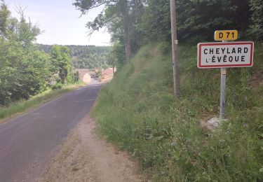
Randonnée V.T.T. de 8,5 km à découvrir à Occitanie, Lozère, Langogne. Cette randonnée est proposée par tracegps.
Description
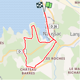
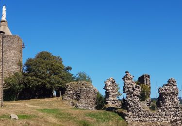
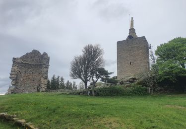
Espace VTT FFC Domaine VTT du Gévaudan Circuit labellisé par la Fédération Française de Cyclisme. Situé en plein coeur du Gévaudan, le domaine VTT s'étend sur 13 communes au départ de Langogne, du lac de Naussac au Moure de la Gardille, en passant par les gorges du Langouyrou ou de l'Allier, jusqu'aux hauts plateaux du Tartas, offrant une diversité incomparable de paysages somptueux et sauvages. Espace VTT FFC du Gévaudan - n°01 - Circuit du Petit Lac Ce circuit passe par les bords du « petit » plan d’eau de Naussac, après avoir longé le terrain de golf du Domaine de Barres. Mi-parcours, à l’écart du sentier, se trouve un observatoire à oiseaux. Carte détaillée des circuits en vente à l’Office du Tourisme de Langogne.
Localisation
Commentaires
Randonnées à proximité
![Randonnée Marche Naussac-Fontanes - naussac - Photo](https://media.geolcdn.com/t/375/260/ext.jpg?maxdim=2&url=https%3A%2F%2Fservices.sitytrail.com%2FGeolivesWS%2FDownloadMedia.ashx%3FTrailID%3D208949%26Media%3Dfix__20130730162442.jpg)
![Marche Marche](https://static1.geolcdn.com/sitytour/trail-icons/101.png)
Marche
![](/images/other/stat-length.png)
![](https://static1.geolcdn.com/siteimages/upload/files/16400158638029165_repeat_loop_refresh_sync_direction_icon.png)
![Randonnée V.T.T. Langogne - Espace VTT FFC du Gévaudan - n°08 - Circuit du Ras Chambon - Photo](https://media.geolcdn.com/t/375/260/ext.jpg?maxdim=2&url=https%3A%2F%2Fservices.sitytrail.com%2FGeolivesWS%2FDownloadMedia.ashx%3FTrailID%3D102665%26Media%3D3674_1.jpg)
![V.T.T. V.T.T.](https://static1.geolcdn.com/sitytour/trail-icons/202.png)
V.T.T.
![](/images/other/stat-length.png)
![](https://static1.geolcdn.com/siteimages/upload/files/16400158638029165_repeat_loop_refresh_sync_direction_icon.png)
![Randonnée Vélo de route Langogne - Langogne, le nouveau monde - Photo](https://media.geolcdn.com/t/375/260/da33af3e-6429-4314-8b80-a9ce97f3ff9d.jpg&format=jpg&maxdim=2)
![Vélo de route Vélo de route](https://static1.geolcdn.com/sitytour/trail-icons/201.png)
Vélo de route
![](/images/other/stat-length.png)
![](https://static1.geolcdn.com/siteimages/upload/files/16400158638029165_repeat_loop_refresh_sync_direction_icon.png)
![Randonnée Course à pied Rocles - Rocles - Photo](https://media.geolcdn.com/t/375/260/4b6604bf-38c6-4644-b4d1-e9fbcf2f9358.jpg&format=jpg&maxdim=2)
![Course à pied Course à pied](https://static1.geolcdn.com/sitytour/trail-icons/103.png)
![Randonnée Marche Langogne - E4 Langogne - Luc GR70 - Photo](https://media.geolcdn.com/t/375/260/1c56381b-c00a-405a-bfd0-d26b1cee708f.jpg&format=jpg&maxdim=2)
![Marche Marche](https://static1.geolcdn.com/sitytour/trail-icons/101.png)
Marche
![](/images/other/stat-length.png)
![](https://static1.geolcdn.com/siteimages/upload/files/16400158638029165_repeat_loop_refresh_sync_direction_icon.png)
![Randonnée Marche Pradelles - Etape 3 Pradelles Haut cheylard l évêque - Photo](https://media.geolcdn.com/t/375/260/ce1558d8-841b-4f17-9992-c0d9828b0b71.jpg&format=jpg&maxdim=2)
![Marche Marche](https://static1.geolcdn.com/sitytour/trail-icons/101.png)
Marche
![](/images/other/stat-length.png)
![](https://static1.geolcdn.com/siteimages/upload/files/16400158638029165_repeat_loop_refresh_sync_direction_icon.png)
![Randonnée Randonnée équestre Rocles - Jojo2 - Photo](https://media.geolcdn.com/t/375/260/ext.jpg?maxdim=2&url=https%3A%2F%2Fstatic1.geolcdn.com%2Fsiteimages%2Fupload%2Ffiles%2F1524743154cheval.jpg)
![Randonnée équestre Randonnée équestre](https://static1.geolcdn.com/sitytour/trail-icons/301.png)
Randonnée équestre
![](/images/other/stat-length.png)
![](https://static1.geolcdn.com/siteimages/upload/files/16400158638029165_repeat_loop_refresh_sync_direction_icon.png)
![Randonnée Marche Langogne - 09-05-2023 E4 Langogne - Luc - Photo](https://media.geolcdn.com/t/375/260/8aa4ecd6-c9b0-4973-b359-d5c3520516bf.jpg&format=jpg&maxdim=2)
![Marche Marche](https://static1.geolcdn.com/sitytour/trail-icons/101.png)
Marche
![](/images/other/stat-length.png)
![](https://static1.geolcdn.com/siteimages/upload/files/16400158638029165_repeat_loop_refresh_sync_direction_icon.png)
![Randonnée Marche Saint-Flour-de-Mercoire - le chélard - Photo](https://media.geolcdn.com/t/375/260/95b8db69-3dce-47bc-9f31-4efaab872b01.jpg&format=jpg&maxdim=2)
![Marche Marche](https://static1.geolcdn.com/sitytour/trail-icons/101.png)
Marche
![](/images/other/stat-length.png)
![](https://static1.geolcdn.com/siteimages/upload/files/16400158638029165_repeat_loop_refresh_sync_direction_icon.png)