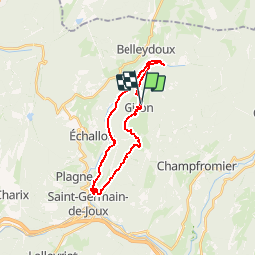
![](/images/other/stat-length.png)
![Randonnée V.T.T. Giron - Espace VTT FFC Entre Jura et Léman - Circuit n°14 - Photo](https://media.geolcdn.com/t/1900/400/ext.pjpeg?maxdim=2&url=https%3A%2F%2Fservices.sitytrail.com%2FGeolivesWS%2FDownloadMedia.ashx%3FTrailID%3D102577%26Media%3D3473_1.jpg)
Espace VTT FFC Entre Jura et Léman - Circuit n°14
tracegps
Utilisateur
![Longueur](/images/other/stat-length.png)
![Altitude max](https://static1.geolcdn.com/siteimages/upload/files/1508320355ic_sort_altitude_max_24dp.png)
![Dénivelé positif](https://static1.geolcdn.com/siteimages/upload/files/1508320355ic_sort_den_pos_24dp.png)
![Km-Effort](/images/other/stat-length.png)
![Altitude min](https://static1.geolcdn.com/siteimages/upload/files/1508320355ic_sort_altitude_min_24dp.png)
![Dénivelé négatif](https://static1.geolcdn.com/siteimages/upload/files/1508320355ic_sort_den_neg_24dp.png)
![Boucle](https://static1.geolcdn.com/siteimages/upload/files/16400158638029165_repeat_loop_refresh_sync_direction_icon.png)
![V.T.T.](https://static1.geolcdn.com/sitytour/trail-icons/202.png)
2h00
Difficulté : Difficile
![Scannez ce code QR pour ouvrir la randonnée dans l'application SityTrail](https://capi.geolives.com/qq0zvz2zws4bq2lad0pu/sitytour/trails/102577/qr.png?size=200)
Application GPS de randonnée GRATUITE
À propos
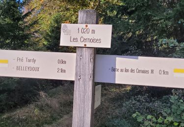
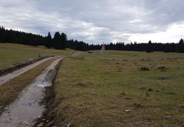
Randonnée V.T.T. de 21 km à découvrir à Auvergne-Rhône-Alpes, Ain, Giron. Cette randonnée est proposée par tracegps.
Description
Espace VTT FFC Entre Jura et Léman Circuit officiel labellisé par la Fédération Française de Cyclisme. L'espace VTT FFC Pays de Gex Bellegarde regroupe 13 circuits VTT au départ de 5 sites, répartis sur tout le territoire. Des Monts Jura au plateau de Retord, de la vallée de la Valserine à la plaine du Pays de Gex, le vététiste bucolique ou plus sportif y trouvera un choix d'itinéraires aussi varié que nos paysages. Vous pourrez emprunter les tracés des sentiers de La Grande Traversée du Jura, itinéraire de randonnées de 370 km traversant le Jura du Nord au Sud.Au Col de la Faucille, empruntez des itinéraires spécialement tracés pour découvrir le VTT en famille. Pour tout renseignement sur la pratique du VTT sur le Pays de Gex-Bellegarde, contacter Bruno LADET à bladet chez ccpg point fr
Localisation
Commentaires
Randonnées à proximité
![Randonnée Marche Échallon - prairie d'échallon belleydoux la borne aux lion des cernoises - Photo](https://media.geolcdn.com/t/375/260/da7a05d9-867e-415c-90dc-474e2d70cbe0.jpg&format=jpg&maxdim=2)
![Marche Marche](https://static1.geolcdn.com/sitytour/trail-icons/101.png)
Marche
![](/images/other/stat-length.png)
![](https://static1.geolcdn.com/siteimages/upload/files/16400158638029165_repeat_loop_refresh_sync_direction_icon.png)
![Randonnée Marche Belleydoux - belleydoux roches d'orvaz - Photo](https://media.geolcdn.com/t/375/260/ext.jpg?maxdim=2&url=https%3A%2F%2Fstatic1.geolcdn.com%2Fsiteimages%2Fupload%2Ffiles%2F1553511878bg_sport_marche.png)
![Marche Marche](https://static1.geolcdn.com/sitytour/trail-icons/101.png)
Marche
![](/images/other/stat-length.png)
![](https://static1.geolcdn.com/siteimages/upload/files/16400158638029165_repeat_loop_refresh_sync_direction_icon.png)
![Randonnée Marche Giron - giron - Photo](https://media.geolcdn.com/t/375/260/99f491d7-7281-4330-b0aa-0f336dca16fb.jpg&format=jpg&maxdim=2)
![Marche Marche](https://static1.geolcdn.com/sitytour/trail-icons/101.png)
![Randonnée Raquettes à neige Giron - giron - Photo](https://media.geolcdn.com/t/375/260/ffd83a0d-f23c-4dee-bfbc-162b2a4ae3d4.jpg&format=jpg&maxdim=2)
![Raquettes à neige Raquettes à neige](https://static1.geolcdn.com/sitytour/trail-icons/504.png)
Raquettes à neige
![](/images/other/stat-length.png)
![](https://static1.geolcdn.com/siteimages/upload/files/16400158638029165_repeat_loop_refresh_sync_direction_icon.png)
![Randonnée Marche Échallon - echallon - Photo](https://media.geolcdn.com/t/375/260/ext.jpg?maxdim=2&url=https%3A%2F%2Fstatic1.geolcdn.com%2Fsiteimages%2Fupload%2Ffiles%2F1553511878bg_sport_marche.png)
![Marche Marche](https://static1.geolcdn.com/sitytour/trail-icons/101.png)
Marche
![](/images/other/stat-length.png)
![](https://static1.geolcdn.com/siteimages/upload/files/16400158638029165_repeat_loop_refresh_sync_direction_icon.png)
![Randonnée Marche Échallon - Echallon: moyenne Semine - Photo](https://media.geolcdn.com/t/375/260/faf68926-9cf8-4b3a-af75-0d8aa555f58d.jpg&format=jpg&maxdim=2)
![Marche Marche](https://static1.geolcdn.com/sitytour/trail-icons/101.png)
Marche
![](/images/other/stat-length.png)
![](https://static1.geolcdn.com/siteimages/upload/files/16400158638029165_repeat_loop_refresh_sync_direction_icon.png)
![Randonnée Marche Échallon - Forêt d'Echallon, de Belleydoux - Photo](https://media.geolcdn.com/t/375/260/02785ae5-715e-48f3-ae7c-2ea4666ed26d.jpg&format=jpg&maxdim=2)
![Marche Marche](https://static1.geolcdn.com/sitytour/trail-icons/101.png)
Marche
![](/images/other/stat-length.png)
![](https://static1.geolcdn.com/siteimages/upload/files/16400158638029165_repeat_loop_refresh_sync_direction_icon.png)
![Randonnée Marche Champfromier - Champfromier les avalanches - Photo](https://media.geolcdn.com/t/375/260/81128839-d6c8-4d06-8106-f2beb8952e7a.jpg&format=jpg&maxdim=2)
![Marche Marche](https://static1.geolcdn.com/sitytour/trail-icons/101.png)
Marche
![](/images/other/stat-length.png)
![](https://static1.geolcdn.com/siteimages/upload/files/16400158638029165_repeat_loop_refresh_sync_direction_icon.png)
![Randonnée Randonnée équestre Giron - 202205 rallye Ain J2 Giron-Lelex - Photo](https://media.geolcdn.com/t/375/260/0b51345d-7bed-4f2b-8b3d-0e1840dcbf67.jpg&format=jpg&maxdim=2)
![Randonnée équestre Randonnée équestre](https://static1.geolcdn.com/sitytour/trail-icons/301.png)
Randonnée équestre
![](/images/other/stat-length.png)
![](https://static1.geolcdn.com/siteimages/upload/files/16400158638029165_repeat_loop_refresh_sync_direction_icon.png)