![](/images/other/stat-length.png)
![Randonnée V.T.T. Allos - Espace VTT FFC Val d'Allos - Circuit n° 04 - Le Brec - Photo](https://media.geolcdn.com/t/1900/400/ext.pjpeg?maxdim=2&url=https%3A%2F%2Fservices.sitytrail.com%2FGeolivesWS%2FDownloadMedia.ashx%3FTrailID%3D102546%26Media%3D3418_1.jpg)
Espace VTT FFC Val d'Allos - Circuit n° 04 - Le Brec
tracegps
Utilisateur
![Longueur](/images/other/stat-length.png)
![Altitude max](https://static1.geolcdn.com/siteimages/upload/files/1508320355ic_sort_altitude_max_24dp.png)
![Dénivelé positif](https://static1.geolcdn.com/siteimages/upload/files/1508320355ic_sort_den_pos_24dp.png)
![Km-Effort](/images/other/stat-length.png)
![Altitude min](https://static1.geolcdn.com/siteimages/upload/files/1508320355ic_sort_altitude_min_24dp.png)
![Dénivelé négatif](https://static1.geolcdn.com/siteimages/upload/files/1508320355ic_sort_den_neg_24dp.png)
![Boucle](https://static1.geolcdn.com/siteimages/upload/files/16400158638029165_repeat_loop_refresh_sync_direction_icon.png)
![V.T.T.](https://static1.geolcdn.com/sitytour/trail-icons/202.png)
1h00
Difficulté : Difficile
![Scannez ce code QR pour ouvrir la randonnée dans l'application SityTrail](https://capi.geolives.com/qq0zvz2zws4bq2lad0pu/sitytour/trails/102546/qr.png?size=200)
Application GPS de randonnée GRATUITE
À propos
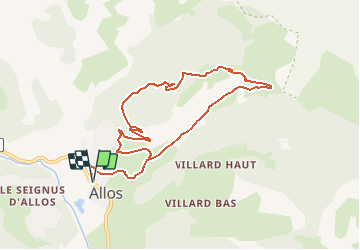
Randonnée V.T.T. de 10,1 km à découvrir à Provence-Alpes-Côte d'Azur, Alpes-de-Haute-Provence, Allos. Cette randonnée est proposée par tracegps.
Description
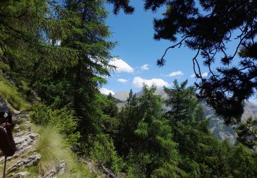
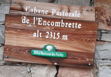
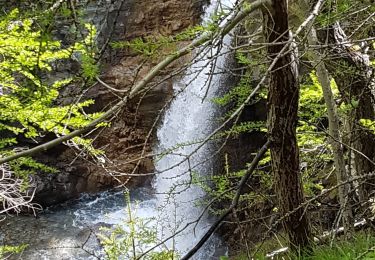
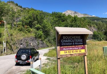
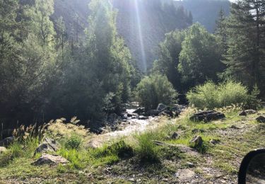
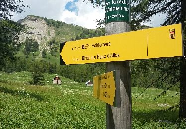
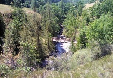
Espace VTT FFC Val d’Allos . Espace VTT FFC Val d'Allos - Circuit n° 04 - Le Brec Départ de Val d’Allos 1400 – Allos Circuit officiel labellisé par la Fédération Française de Cyclisme. Ce circuit traverse la forêt de Vacheresse puis le hameau du Brec avant de rejoindre Allos en longeant l’impétueux Chadoulin, torrent issu d’une résurgence du lac d’Allos. L’espace VTT FFC du Val d’Allos – Haut Verdon vous propose plus de 100 kilomètres de pistes et chemins forestiers. Sous le soleil des Alpes de Haute Provence vous profiterez de la montagne sur des circuits adaptés pour tous les niveaux et toutes les envies. Parcours à profil descendant sur le site de Val d’Allos 1500 – Le Seignus, ou parcours vallonnés dans le reste de la vallée vous roulerez dans les sous-bois ou les alpages du pays des sources, des lacs et des montagnes. De sapins en mélèzes, de prairies en alpages, plusieurs dizaines de kilomètres balisés pour la pratique du VTT vous attendent... De plus, une diversité d'itinéraires descendants vous sont proposés au départ des remontées mécaniques ouvertes. Envie d'une paisible randonnée ou d'une descente endiablée... un dépliant est à votre disposition dans les offices de tourisme.
Localisation
Commentaires
Randonnées à proximité
![Randonnée Marche Colmars - clignon encombrette - Photo](https://media.geolcdn.com/t/375/260/be8c3d38-73f7-4208-88b1-25cf6491a9c9.jpg&format=jpg&maxdim=2)
![Marche Marche](https://static1.geolcdn.com/sitytour/trail-icons/101.png)
Marche
![](/images/other/stat-length.png)
![](https://static1.geolcdn.com/siteimages/upload/files/16400158638029165_repeat_loop_refresh_sync_direction_icon.png)
![Randonnée Marche Colmars - Col de l](https://media.geolcdn.com/t/375/260/09a91b7d-2e2d-4897-a96c-c33d12bc529d.jpg&format=jpg&maxdim=2)
![Marche Marche](https://static1.geolcdn.com/sitytour/trail-icons/101.png)
Marche
![](/images/other/stat-length.png)
![](https://static1.geolcdn.com/siteimages/upload/files/16400158638029165_repeat_loop_refresh_sync_direction_icon.png)
![Randonnée Marche Allos - Allos:rando à partir de la Haute Colette - Photo](https://media.geolcdn.com/t/375/260/493206fb-ef34-4df9-a198-c7ff23e42e5c.jpg&format=jpg&maxdim=2)
![Marche Marche](https://static1.geolcdn.com/sitytour/trail-icons/101.png)
Marche
![](/images/other/stat-length.png)
![](https://static1.geolcdn.com/siteimages/upload/files/16400158638029165_repeat_loop_refresh_sync_direction_icon.png)
![Randonnée Marche Colmars - col de l'encombrette pas de L'Echellette - Photo](https://media.geolcdn.com/t/375/260/e4efe46f-86ba-4576-b21d-bdc6efd2fc20.jpg&format=jpg&maxdim=2)
![Marche Marche](https://static1.geolcdn.com/sitytour/trail-icons/101.png)
Marche
![](/images/other/stat-length.png)
![](https://static1.geolcdn.com/siteimages/upload/files/16400158638029165_repeat_loop_refresh_sync_direction_icon.png)
![Randonnée Marche Allos - lac d allos - Photo](https://media.geolcdn.com/t/375/260/e2c2cb96-4a4e-43e8-9ad1-3b50e7ed0175.jpg&format=jpg&maxdim=2)
![Marche Marche](https://static1.geolcdn.com/sitytour/trail-icons/101.png)
Marche
![](/images/other/stat-length.png)
![](https://static1.geolcdn.com/siteimages/upload/files/16400158638029165_repeat_loop_refresh_sync_direction_icon.png)
![Randonnée 4x4 Allos - Piste de Bouchier - Photo](https://media.geolcdn.com/t/375/260/ext.jpg?maxdim=2&url=https%3A%2F%2Fservices.sitytrail.com%2FGeolivesWS%2FDownloadMedia.ashx%3FTrailID%3D1019478%26Media%3D20180810112850.jpg)
![4x4 4x4](https://static1.geolcdn.com/sitytour/trail-icons/403.png)
4x4
![](/images/other/stat-length.png)
![](https://static1.geolcdn.com/siteimages/upload/files/16400158638029165_repeat_loop_refresh_sync_direction_icon.png)
![Randonnée 4x4 Villars-Colmars - Piste de chasse - Photo](https://media.geolcdn.com/t/375/260/ext.jpg?maxdim=2&url=https%3A%2F%2Fservices.sitytrail.com%2FGeolivesWS%2FDownloadMedia.ashx%3FTrailID%3D1018803%26Media%3D20180809093118.jpg)
![4x4 4x4](https://static1.geolcdn.com/sitytour/trail-icons/403.png)
4x4
![](/images/other/stat-length.png)
![](https://static1.geolcdn.com/siteimages/upload/files/16400158638029165_repeat_loop_refresh_sync_direction_icon.png)
![Randonnée Marche Allos - Le Seignus Haut - MF de Valdemars - Photo](https://media.geolcdn.com/t/375/260/ext.jpg?maxdim=2&url=https%3A%2F%2Fservices.sitytrail.com%2FGeolivesWS%2FDownloadMedia.ashx%3FTrailID%3D999663%26Media%3Dfix__20180705124814.jpg)
![Marche Marche](https://static1.geolcdn.com/sitytour/trail-icons/101.png)
Marche
![](/images/other/stat-length.png)
![](https://static1.geolcdn.com/siteimages/upload/files/16400158638029165_repeat_loop_refresh_sync_direction_icon.png)
![Randonnée Marche Allos - Allos -Le Brec - Allos - Photo](https://media.geolcdn.com/t/375/260/ext.jpg?maxdim=2&url=https%3A%2F%2Fservices.sitytrail.com%2FGeolivesWS%2FDownloadMedia.ashx%3FTrailID%3D148002%26Media%3D20120818140647.jpeg)
![Marche Marche](https://static1.geolcdn.com/sitytour/trail-icons/101.png)
Marche
![](/images/other/stat-length.png)
![](https://static1.geolcdn.com/siteimages/upload/files/16400158638029165_repeat_loop_refresh_sync_direction_icon.png)