![](/images/other/stat-length.png)
![Randonnée Marche Saint-Léger-sous-Cholet - Randonnée du Boudin - Photo](https://media.geolcdn.com/t/1900/400/ext.pjpeg?maxdim=2&url=https%3A%2F%2Fstatic1.geolcdn.com%2Fsiteimages%2Fupload%2Ffiles%2F1553511878bg_sport_marche.png)
Randonnée du Boudin
tracegps
Utilisateur
![Longueur](/images/other/stat-length.png)
Longueur
16,7 km
![Altitude max](https://static1.geolcdn.com/siteimages/upload/files/1508320355ic_sort_altitude_max_24dp.png)
Altitude max
129 m
![Dénivelé positif](https://static1.geolcdn.com/siteimages/upload/files/1508320355ic_sort_den_pos_24dp.png)
Dénivelé positif
102 m
![Km-Effort](/images/other/stat-length.png)
Km-Effort
18,1 km
![Altitude min](https://static1.geolcdn.com/siteimages/upload/files/1508320355ic_sort_altitude_min_24dp.png)
Altitude min
92 m
![Dénivelé négatif](https://static1.geolcdn.com/siteimages/upload/files/1508320355ic_sort_den_neg_24dp.png)
Dénivelé négatif
100 m
![Boucle](https://static1.geolcdn.com/siteimages/upload/files/16400158638029165_repeat_loop_refresh_sync_direction_icon.png)
Boucle
Oui
Date de création :
2014-12-10 00:00:00.0
Dernière modification :
2014-12-10 00:00:00.0
![Marche](https://static1.geolcdn.com/sitytour/trail-icons/101.png)
2h40
Difficulté : Moyen
![Scannez ce code QR pour ouvrir la randonnée dans l'application SityTrail](https://capi.geolives.com/qq0zvz2zws4bq2lad0pu/sitytour/trails/102445/qr.png?size=200)
Application GPS de randonnée GRATUITE
À propos
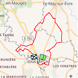
Randonnée Marche de 16,7 km à découvrir à Pays de la Loire, Maine-et-Loire, Saint-Léger-sous-Cholet. Cette randonnée est proposée par tracegps.
Description
Circuit sans grande difficulté, sauf que le passage dans des propriétés privées a été autorisés pour cette randonnée.
Localisation
Pays :
France
Région :
Pays de la Loire
Département/Province :
Maine-et-Loire
Commune :
Saint-Léger-sous-Cholet
Localité :
Unknown
Départ:(Dec)
Départ:(UTM)
658349 ; 5217413 (30T) N.
Commentaires
Randonnées à proximité
![Randonnée Autre activité Cholet - Cholet-Nantes - Photo](https://media.geolcdn.com/t/375/260/ext.jpg?maxdim=2&url=https%3A%2F%2Fstatic1.geolcdn.com%2Fsiteimages%2Fupload%2Ffiles%2F1545311037marcheuse_200dpi.jpg)
![Autre activité Autre activité](https://static1.geolcdn.com/sitytour/trail-icons/900.png)
Cholet-Nantes
Autre activité
Très facile
(2)
Cholet,
Pays de la Loire,
Maine-et-Loire,
France
![](/images/other/stat-length.png)
78 km | 86 km-effort
Inconnu
![](https://static1.geolcdn.com/siteimages/upload/files/16400158638029165_repeat_loop_refresh_sync_direction_icon.png)
Non
![Randonnée Course à pied Cholet - Autour de Cholet - Photo](https://media.geolcdn.com/t/375/260/ext.jpg?maxdim=2&url=https%3A%2F%2Fservices.sitytrail.com%2FGeolivesWS%2FDownloadMedia.ashx%3FTrailID%3D215228%26Media%3D15843_3.jpg)
![Course à pied Course à pied](https://static1.geolcdn.com/sitytour/trail-icons/103.png)
Autour de Cholet
Course à pied
Moyen
Cholet,
Pays de la Loire,
Maine-et-Loire,
France
![](/images/other/stat-length.png)
11,9 km | 13,5 km-effort
1h 15min
![](https://static1.geolcdn.com/siteimages/upload/files/16400158638029165_repeat_loop_refresh_sync_direction_icon.png)
Oui
![Randonnée Marche Cholet - Autour de Cholet - Photo](https://media.geolcdn.com/t/375/260/ext.jpg?maxdim=2&url=https%3A%2F%2Fservices.sitytrail.com%2FGeolivesWS%2FDownloadMedia.ashx%3FTrailID%3D215227%26Media%3D15843_3.jpg)
![Marche Marche](https://static1.geolcdn.com/sitytour/trail-icons/101.png)
Autour de Cholet
Marche
Moyen
Cholet,
Pays de la Loire,
Maine-et-Loire,
France
![](/images/other/stat-length.png)
11,9 km | 13,5 km-effort
2h 30min
![](https://static1.geolcdn.com/siteimages/upload/files/16400158638029165_repeat_loop_refresh_sync_direction_icon.png)
Oui
![Randonnée V.T.T. La Séguinière - La Séguinière 2023 - Photo](https://media.geolcdn.com/t/375/260/ext.jpg?maxdim=2&url=https%3A%2F%2Fstatic1.geolcdn.com%2Fsiteimages%2Fupload%2Ffiles%2F1524743154velo.jpg)
![V.T.T. V.T.T.](https://static1.geolcdn.com/sitytour/trail-icons/202.png)
La Séguinière 2023
V.T.T.
Difficile
La Séguinière,
Pays de la Loire,
Maine-et-Loire,
France
![](/images/other/stat-length.png)
36 km | 42 km-effort
3h 54min
![](https://static1.geolcdn.com/siteimages/upload/files/16400158638029165_repeat_loop_refresh_sync_direction_icon.png)
Oui
![Randonnée V.T.T. La Séguinière - La Séguinière 2022 - Photo](https://media.geolcdn.com/t/375/260/ext.jpg?maxdim=2&url=https%3A%2F%2Fstatic1.geolcdn.com%2Fsiteimages%2Fupload%2Ffiles%2F1524743154velo.jpg)
![V.T.T. V.T.T.](https://static1.geolcdn.com/sitytour/trail-icons/202.png)
La Séguinière 2022
V.T.T.
Difficile
La Séguinière,
Pays de la Loire,
Maine-et-Loire,
France
![](/images/other/stat-length.png)
32 km | 36 km-effort
2h 51min
![](https://static1.geolcdn.com/siteimages/upload/files/16400158638029165_repeat_loop_refresh_sync_direction_icon.png)
Oui
![Randonnée Marche La Séguinière - La Séguinière - Photo](https://media.geolcdn.com/t/375/260/ext.jpg?maxdim=2&url=https%3A%2F%2Fstatic1.geolcdn.com%2Fsiteimages%2Fupload%2Ffiles%2F1553511878bg_sport_marche.png)
![Marche Marche](https://static1.geolcdn.com/sitytour/trail-icons/101.png)
La Séguinière
Marche
Facile
La Séguinière,
Pays de la Loire,
Maine-et-Loire,
France
![](/images/other/stat-length.png)
10,9 km | 12,7 km-effort
2h 47min
![](https://static1.geolcdn.com/siteimages/upload/files/16400158638029165_repeat_loop_refresh_sync_direction_icon.png)
Oui
![Randonnée Marche La Séguinière - rando du bouchot 2013 - Photo](https://media.geolcdn.com/t/375/260/ext.jpg?maxdim=2&url=https%3A%2F%2Fstatic1.geolcdn.com%2Fsiteimages%2Fupload%2Ffiles%2F1553511878bg_sport_marche.png)
![Marche Marche](https://static1.geolcdn.com/sitytour/trail-icons/101.png)
rando du bouchot 2013
Marche
Très facile
La Séguinière,
Pays de la Loire,
Maine-et-Loire,
France
![](/images/other/stat-length.png)
17,2 km | 20 km-effort
3h 6min
![](https://static1.geolcdn.com/siteimages/upload/files/16400158638029165_repeat_loop_refresh_sync_direction_icon.png)
Oui
![Randonnée V.T.T. Saint-Léger-sous-Cholet - Rando VTT St Leger sous Cholet - Photo](https://media.geolcdn.com/t/375/260/ext.jpg?maxdim=2&url=https%3A%2F%2Fstatic1.geolcdn.com%2Fsiteimages%2Fupload%2Ffiles%2F1524743154velo.jpg)
![V.T.T. V.T.T.](https://static1.geolcdn.com/sitytour/trail-icons/202.png)
Rando VTT St Leger sous Cholet
V.T.T.
Très facile
Saint-Léger-sous-Cholet,
Pays de la Loire,
Maine-et-Loire,
France
![](/images/other/stat-length.png)
39 km | 44 km-effort
1h 49min
![](https://static1.geolcdn.com/siteimages/upload/files/16400158638029165_repeat_loop_refresh_sync_direction_icon.png)
Oui
![Randonnée V.T.T. Cholet - Tour du Lac de Verdon - Photo](https://media.geolcdn.com/t/375/260/ext.jpg?maxdim=2&url=https%3A%2F%2Fstatic1.geolcdn.com%2Fsiteimages%2Fupload%2Ffiles%2F1524743154velo.jpg)
![V.T.T. V.T.T.](https://static1.geolcdn.com/sitytour/trail-icons/202.png)
Tour du Lac de Verdon
V.T.T.
Moyen
Cholet,
Pays de la Loire,
Maine-et-Loire,
France
![](/images/other/stat-length.png)
31 km | 34 km-effort
2h 0min
![](https://static1.geolcdn.com/siteimages/upload/files/16400158638029165_repeat_loop_refresh_sync_direction_icon.png)
Oui