![](/images/other/stat-length.png)
![Randonnée V.T.T. Belvédère-Campomoro - Piopelii - Campomoro - Photo](https://media.geolcdn.com/t/1900/400/ext.pjpeg?maxdim=2&url=https%3A%2F%2Fstatic1.geolcdn.com%2Fsiteimages%2Fupload%2Ffiles%2F1524743154velo.jpg)
Piopelii - Campomoro
tracegps
Utilisateur
![Longueur](/images/other/stat-length.png)
![Altitude max](https://static1.geolcdn.com/siteimages/upload/files/1508320355ic_sort_altitude_max_24dp.png)
![Dénivelé positif](https://static1.geolcdn.com/siteimages/upload/files/1508320355ic_sort_den_pos_24dp.png)
![Km-Effort](/images/other/stat-length.png)
![Altitude min](https://static1.geolcdn.com/siteimages/upload/files/1508320355ic_sort_altitude_min_24dp.png)
![Dénivelé négatif](https://static1.geolcdn.com/siteimages/upload/files/1508320355ic_sort_den_neg_24dp.png)
![Boucle](https://static1.geolcdn.com/siteimages/upload/files/16400158638029165_repeat_loop_refresh_sync_direction_icon.png)
![V.T.T.](https://static1.geolcdn.com/sitytour/trail-icons/202.png)
3h00
Difficulté : Très difficile
![Scannez ce code QR pour ouvrir la randonnée dans l'application SityTrail](https://capi.geolives.com/qq0zvz2zws4bq2lad0pu/sitytour/trails/102409/qr.png?size=200)
Application GPS de randonnée GRATUITE
À propos
Randonnée V.T.T. de 11,2 km à découvrir à Corse, Corse-du-Sud, Belvédère-Campomoro. Cette randonnée est proposée par tracegps.
Description
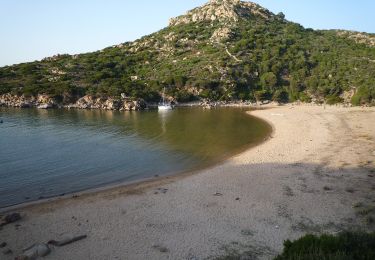
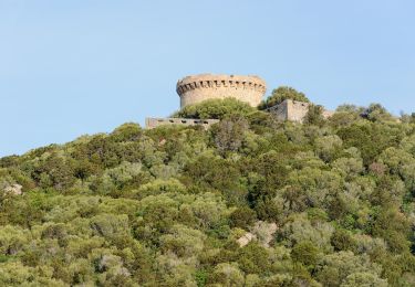
Circuit de découverte du maquis Corse, prévoir des gants long et bien se protéger bras et jambes. Le maquis, ça pique! Passages difficiles avec portage. Prévoir une bonne réserve d'eau par forte chaleur. Au sud de Propriano en longeant la côte, le petit village de Campomoro est situé sur un site classé et protégé. Cette ville tire son nom de "camp des maures". Une fois de plus l'histoire n'est pas bien loin. Cette petite bourgade a su garder son originalité et loin des grandes concentrations touristiques, reste un endroit privilégié pour des vacances calmes en bord de mer. De Campomoro vous pouvez rejoindre Belvédère situé un peu plus dans les terres. De là, la vue sur le Golfe de Valinco est des plus exceptionnelle. Source Vacances Corse.
Localisation
Commentaires
Randonnées à proximité
![Randonnée Marche Belvédère-Campomoro - campomoro le jardin du vent - Photo](https://media.geolcdn.com/t/375/260/8a1d6b32-5ef7-4851-a4c5-9cde8d1396fb.jpg&format=jpg&maxdim=2)
![Marche Marche](https://static1.geolcdn.com/sitytour/trail-icons/101.png)
Marche
![](/images/other/stat-length.png)
![](https://static1.geolcdn.com/siteimages/upload/files/16400158638029165_repeat_loop_refresh_sync_direction_icon.png)
![Randonnée Marche Belvédère-Campomoro - Corse-Cala Agulia 14.09.2015 - Photo](https://media.geolcdn.com/t/375/260/ext.jpg?maxdim=2&url=https%3A%2F%2Fstatic1.geolcdn.com%2Fsiteimages%2Fupload%2Ffiles%2F1553511878bg_sport_marche.png)
![Marche Marche](https://static1.geolcdn.com/sitytour/trail-icons/101.png)
Marche
![](/images/other/stat-length.png)
![](https://static1.geolcdn.com/siteimages/upload/files/16400158638029165_repeat_loop_refresh_sync_direction_icon.png)
![Randonnée Marche Belvédère-Campomoro - Tour de Campomoro - Photo](https://media.geolcdn.com/t/375/260/09c9781f-81c6-41eb-a1ef-19cdbb83c180.jpg&format=jpg&maxdim=2)
![Marche Marche](https://static1.geolcdn.com/sitytour/trail-icons/101.png)
Marche
![](/images/other/stat-length.png)
![](https://static1.geolcdn.com/siteimages/upload/files/16400158638029165_repeat_loop_refresh_sync_direction_icon.png)
![Randonnée Marche Belvédère-Campomoro - Campomoro - Photo](https://media.geolcdn.com/t/375/260/55292ca0-df13-41a4-b38c-b44822832324.jpg&format=jpg&maxdim=2)
![Marche Marche](https://static1.geolcdn.com/sitytour/trail-icons/101.png)
Marche
![](/images/other/stat-length.png)
![](https://static1.geolcdn.com/siteimages/upload/files/16400158638029165_repeat_loop_refresh_sync_direction_icon.png)
![Randonnée Marche Belvédère-Campomoro - Tour de Campomoro - Photo](https://media.geolcdn.com/t/375/260/42c99279-a72c-44b7-a9a7-7aad71bf9cdc.jpg&format=jpg&maxdim=2)
![Marche Marche](https://static1.geolcdn.com/sitytour/trail-icons/101.png)
Marche
![](/images/other/stat-length.png)
![](https://static1.geolcdn.com/siteimages/upload/files/16400158638029165_repeat_loop_refresh_sync_direction_icon.png)
![Randonnée A pied Belvédère-Campomoro - Sentier Littoral - Photo](https://media.geolcdn.com/t/375/260/f5fb84e2-387c-49b8-8e2d-0ed48a13d84e.jpeg&format=jpg&maxdim=2)
![A pied A pied](https://static1.geolcdn.com/sitytour/trail-icons/100.png)
A pied
![](/images/other/stat-length.png)
![](https://static1.geolcdn.com/siteimages/upload/files/16400158638029165_repeat_loop_refresh_sync_direction_icon.png)
![Randonnée A pied Belvédère-Campomoro - Sentier de Belvédère à Campomoro - Photo](https://media.geolcdn.com/t/375/260/ce17b825-d9cf-4592-a59e-d7bf486b4479.jpeg&format=jpg&maxdim=2)
![A pied A pied](https://static1.geolcdn.com/sitytour/trail-icons/100.png)
A pied
![](/images/other/stat-length.png)
![](https://static1.geolcdn.com/siteimages/upload/files/16400158638029165_repeat_loop_refresh_sync_direction_icon.png)
![Randonnée A pied Belvédère-Campomoro - Boucle de Manna Mulina - Photo](https://media.geolcdn.com/t/375/260/2a22e36d-8e0e-4988-9c9f-1a8e4f123173.jpeg&format=jpg&maxdim=2)
![A pied A pied](https://static1.geolcdn.com/sitytour/trail-icons/100.png)
A pied
![](/images/other/stat-length.png)
![](https://static1.geolcdn.com/siteimages/upload/files/16400158638029165_repeat_loop_refresh_sync_direction_icon.png)
![Randonnée A pied Belvédère-Campomoro - Boucle des Canuseddu - Photo](https://media.geolcdn.com/t/375/260/2a22e36d-8e0e-4988-9c9f-1a8e4f123173.jpeg&format=jpg&maxdim=2)
![A pied A pied](https://static1.geolcdn.com/sitytour/trail-icons/100.png)
A pied
![](/images/other/stat-length.png)
![](https://static1.geolcdn.com/siteimages/upload/files/16400158638029165_repeat_loop_refresh_sync_direction_icon.png)