![](/images/other/stat-length.png)
![Randonnée Marche La Ferrière - Autout de La Ferrière et Marray - Photo](https://media.geolcdn.com/t/1900/400/ext.pjpeg?maxdim=2&url=https%3A%2F%2Fstatic1.geolcdn.com%2Fsiteimages%2Fupload%2Ffiles%2F1553511878bg_sport_marche.png)
Autout de La Ferrière et Marray
tracegps
Utilisateur
![Longueur](/images/other/stat-length.png)
Longueur
16,7 km
![Altitude max](https://static1.geolcdn.com/siteimages/upload/files/1508320355ic_sort_altitude_max_24dp.png)
Altitude max
186 m
![Dénivelé positif](https://static1.geolcdn.com/siteimages/upload/files/1508320355ic_sort_den_pos_24dp.png)
Dénivelé positif
219 m
![Km-Effort](/images/other/stat-length.png)
Km-Effort
19,6 km
![Altitude min](https://static1.geolcdn.com/siteimages/upload/files/1508320355ic_sort_altitude_min_24dp.png)
Altitude min
98 m
![Dénivelé négatif](https://static1.geolcdn.com/siteimages/upload/files/1508320355ic_sort_den_neg_24dp.png)
Dénivelé négatif
219 m
![Boucle](https://static1.geolcdn.com/siteimages/upload/files/16400158638029165_repeat_loop_refresh_sync_direction_icon.png)
Boucle
Oui
Date de création :
2014-12-10 00:00:00.0
Dernière modification :
2014-12-10 00:00:00.0
![Marche](https://static1.geolcdn.com/sitytour/trail-icons/101.png)
3h00
Difficulté : Moyen
![Scannez ce code QR pour ouvrir la randonnée dans l'application SityTrail](https://capi.geolives.com/qq0zvz2zws4bq2lad0pu/sitytour/trails/102363/qr.png?size=200)
Application GPS de randonnée GRATUITE
À propos
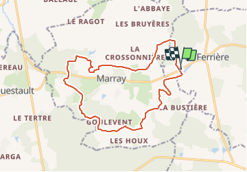
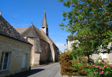
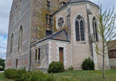
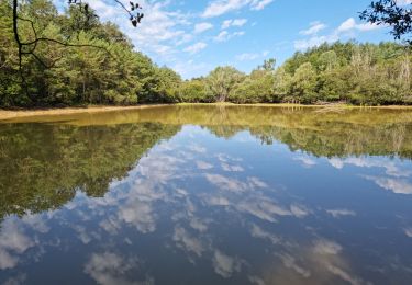
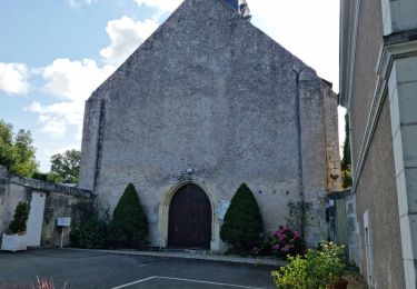
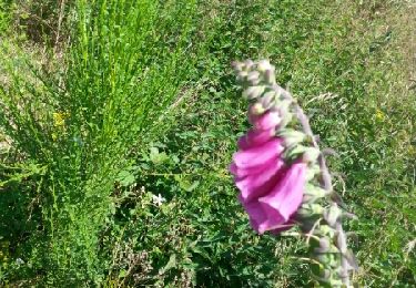
Randonnée Marche de 16,7 km à découvrir à Centre-Val de Loire, Indre-et-Loire, La Ferrière. Cette randonnée est proposée par tracegps.
Description
Boucle autour de La Ferrière et Marray, 17km avec beaucoup de forêt, balisage bleu, balisage temporaire probable, circuit proposé pour une sortie du comité local.
Localisation
Pays :
France
Région :
Centre-Val de Loire
Département/Province :
Indre-et-Loire
Commune :
La Ferrière
Localité :
Unknown
Départ:(Dec)
Départ:(UTM)
329721 ; 5276997 (31T) N.
Commentaires
Randonnées à proximité
![Randonnée Marche Saint-Laurent-en-Gâtines - Saint-Laurent-en-Gâtines - variante du PR Chemin de Chenusson - 10.2km 90m 2h25 - 2023 07 30 - Photo](https://media.geolcdn.com/t/375/260/9480277e-5582-454b-ba7d-ba1780556f7f.jpg&format=jpg&maxdim=2)
![Marche Marche](https://static1.geolcdn.com/sitytour/trail-icons/101.png)
Saint-Laurent-en-Gâtines - variante du PR Chemin de Chenusson - 10.2km 90m 2h...
Marche
Facile
Saint-Laurent-en-Gâtines,
Centre-Val de Loire,
Indre-et-Loire,
France
![](/images/other/stat-length.png)
10,3 km | 11,5 km-effort
2h 25min
![](https://static1.geolcdn.com/siteimages/upload/files/16400158638029165_repeat_loop_refresh_sync_direction_icon.png)
Oui
![Randonnée Marche La Ferrière - la Ferrière - le Moulin à Vent à Saint-Laurent-en-Gâtines - 14.9km 115m 3h20 (30mn) - 2023 07 30 - Photo](https://media.geolcdn.com/t/375/260/d3c77c4c-8983-42fc-ab09-ce988903c800.jpg&format=jpg&maxdim=2)
![Marche Marche](https://static1.geolcdn.com/sitytour/trail-icons/101.png)
la Ferrière - le Moulin à Vent à Saint-Laurent-en-Gâtines - 14.9km 115m 3h20 ...
Marche
Facile
La Ferrière,
Centre-Val de Loire,
Indre-et-Loire,
France
![](/images/other/stat-length.png)
14,9 km | 16,5 km-effort
3h 20min
![](https://static1.geolcdn.com/siteimages/upload/files/16400158638029165_repeat_loop_refresh_sync_direction_icon.png)
Oui
![Randonnée Marche Saint-Laurent-en-Gâtines - Saint-Laurent-en-Gâtines - Circuit jaune avec variante le Sentier - 18.7km 120m 4h30 - 2022 05 01 - Photo](https://media.geolcdn.com/t/375/260/8fa477e2-239d-46b3-938e-82d894cde1c1.jpg&format=jpg&maxdim=2)
![Marche Marche](https://static1.geolcdn.com/sitytour/trail-icons/101.png)
Saint-Laurent-en-Gâtines - Circuit jaune avec variante le Sentier - 18.7km 12...
Marche
Facile
Saint-Laurent-en-Gâtines,
Centre-Val de Loire,
Indre-et-Loire,
France
![](/images/other/stat-length.png)
18,7 km | 20 km-effort
4h 30min
![](https://static1.geolcdn.com/siteimages/upload/files/16400158638029165_repeat_loop_refresh_sync_direction_icon.png)
Oui
![Randonnée Marche Marray - Marray - 2 boucles - 19.2km 245m 5h05 (30mn) - 2021 06 09 - Photo](https://media.geolcdn.com/t/375/260/45a2bb2e-f724-44bd-9abd-5e3ed1735943.jpg&format=jpg&maxdim=2)
![Marche Marche](https://static1.geolcdn.com/sitytour/trail-icons/101.png)
Marray - 2 boucles - 19.2km 245m 5h05 (30mn) - 2021 06 09
Marche
Moyen
Marray,
Centre-Val de Loire,
Indre-et-Loire,
France
![](/images/other/stat-length.png)
19,2 km | 22 km-effort
5h 5min
![](https://static1.geolcdn.com/siteimages/upload/files/16400158638029165_repeat_loop_refresh_sync_direction_icon.png)
Oui
![Randonnée Marche Saint-Laurent-en-Gâtines - Saint-Laurent-en-Gatines - Photo](https://media.geolcdn.com/t/375/260/3bcc51bc-dce3-484e-8c68-f9b9dd3f130d.jpg&format=jpg&maxdim=2)
![Marche Marche](https://static1.geolcdn.com/sitytour/trail-icons/101.png)
Saint-Laurent-en-Gatines
Marche
Difficile
Saint-Laurent-en-Gâtines,
Centre-Val de Loire,
Indre-et-Loire,
France
![](/images/other/stat-length.png)
13,1 km | 14,9 km-effort
3h 23min
![](https://static1.geolcdn.com/siteimages/upload/files/16400158638029165_repeat_loop_refresh_sync_direction_icon.png)
Oui
![Randonnée Marche Marray - Marray - Les versants de la Dême - Photo](https://media.geolcdn.com/t/375/260/a9d7133a-9eea-405b-99f5-2661c5c29f57.jpg&format=jpg&maxdim=2)
![Marche Marche](https://static1.geolcdn.com/sitytour/trail-icons/101.png)
Marray - Les versants de la Dême
Marche
Moyen
Marray,
Centre-Val de Loire,
Indre-et-Loire,
France
![](/images/other/stat-length.png)
12,8 km | 15,2 km-effort
3h 27min
![](https://static1.geolcdn.com/siteimages/upload/files/16400158638029165_repeat_loop_refresh_sync_direction_icon.png)
Oui
![Randonnée Marche La Ferrière - La Ferrière - Photo](https://media.geolcdn.com/t/375/260/2b9da9c8-3be2-44f6-92a4-c42159cd8b74.jpg&format=jpg&maxdim=2)
![Marche Marche](https://static1.geolcdn.com/sitytour/trail-icons/101.png)
La Ferrière
Marche
Facile
La Ferrière,
Centre-Val de Loire,
Indre-et-Loire,
France
![](/images/other/stat-length.png)
10,6 km | 11,9 km-effort
2h 42min
![](https://static1.geolcdn.com/siteimages/upload/files/16400158638029165_repeat_loop_refresh_sync_direction_icon.png)
Oui
![Randonnée Marche Les Hermites - sentier de l'ermite - Photo](https://media.geolcdn.com/t/375/260/ext.jpg?maxdim=2&url=https%3A%2F%2Fservices.sitytrail.com%2FGeolivesWS%2FDownloadMedia.ashx%3FTrailID%3D315383%26Media%3Dfix__20140622121912.jpg)
![Marche Marche](https://static1.geolcdn.com/sitytour/trail-icons/101.png)
sentier de l'ermite
Marche
Très facile
Les Hermites,
Centre-Val de Loire,
Indre-et-Loire,
France
![](/images/other/stat-length.png)
25 km | 28 km-effort
5h 29min
![](https://static1.geolcdn.com/siteimages/upload/files/16400158638029165_repeat_loop_refresh_sync_direction_icon.png)
Oui
![Randonnée Marche Saint-Laurent-en-Gâtines - saint laurent en gatine - Photo](https://media.geolcdn.com/t/375/260/ext.jpg?maxdim=2&url=https%3A%2F%2Fservices.sitytrail.com%2FGeolivesWS%2FDownloadMedia.ashx%3FTrailID%3D265906%26Media%3Dfix__20140412112239.jpg)
![Marche Marche](https://static1.geolcdn.com/sitytour/trail-icons/101.png)
saint laurent en gatine
Marche
Facile
Saint-Laurent-en-Gâtines,
Centre-Val de Loire,
Indre-et-Loire,
France
![](/images/other/stat-length.png)
13,9 km | 14,9 km-effort
2h 59min
![](https://static1.geolcdn.com/siteimages/upload/files/16400158638029165_repeat_loop_refresh_sync_direction_icon.png)
Oui